|
Wenlock
Edge Walk
Starting point and OS Grid reference: 
National
Trust free car park just outside Much Wenlock (SO 613996)
|
Ordnance Survey Map
OS
Explorer 217 The Long Mynd and Wenlock Edge.
Buy this map from
List
of OS Maps
| |
Distance: 9.3
miles
|
Date of Walk:
| |
Ascent:
Descent:
See Walking Time Calculator
|
388m (1274)
386m (1267)
| |
Traffic
light rating: 
(For explanation see My
Walks page)
| |


For advice on .gpx files see
My Walks page
|

Click
the PDF logo above to give a printable version of this walk without the
photos.
|
To
view route as a dynamic Ordnance Survey map click here.
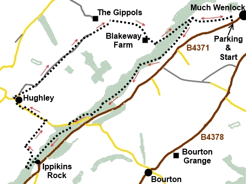
Introduction: This Wenlock Edge walk
from Much Wenlock takes you along about a 3 mile section of the Edge only,
in order to provide a circular walk. Wenlock Edge overall is about 15 miles
long.
Wenlock Edge is a 400 million year old
limestone escarpment just over 1,000 feet high running between the towns of
Ironbridge and Craven Arms. Its elevation provides for lovely views across
the Shropshire countryside. It is covered by ancient woodland and the views
tend to be more special for their occasional appearance from odd vantage
points than if they were continuous.
Originally, it was at the bottom of a
tropical sea and is packed with sea creature fossils. Today it provides a
haven for wildlife and a rich variety of flowering plants, including several
species of orchid.
It has been used as a source of building
materials (limestone and wood) for centuries and there are remains of
quarries and limekilns, which provided lime for local farmers’ fields.
The walk is very easy, mostly along broad
tracks and there is a nice picnic spot for lunch.
The walk starts from a free National Trust
car park immediately outside Much Wenlock, close to the junction of the
B4371 and the A458. The car park is in an old quarry to the north of the
B4371.
Start: The walk starts from the steps
through the gate in the rear right hand corner of the car park (SO 613996).
At the top of the steps, turn left on a well used broad track. At a
multitude of signs, keep straight ahead for Harley Bank.
%20Begining%20the%20walk.jpg)
You soon pass an old lime kiln on the right.
%20Remains%20of%20Old%20Limekiln.jpg)
Stay on the main track until it divides at
the entrance to National Trust land at Wenlock Edge where there is the usual
National Trust sign and a cluster of footpath posts (SO 603996). Fork left
here and almost immediately left again indicated by a blue arrow.
You come to Majors Leap (SO 600991) from
which there is a good view to the north but stay on the main track after
admiring the view. Just past Majors Leap turn where there is a marker post
(indicating Major’s Leap Walk) turn right (SO 599989). The path descends
going back on itself and joins another track where you turn left. There is a
marker post indicating “Presthope 1½ miles”.
%20View%20from%20Majors%20Leap.jpg)
At a track descending to Blakeway Farm,
ignore it and keep straight ahead. When the track splits, keep right,
ignoring a track up to the left which goes to a gate.
Ignore further paths to Major’s Leap and
Blakeway Farm.
When the track divides yet again (SO 583977),
at a post indicating left is to Presthope, and Lea Quarry Walk, take the
right fork.
%20Track%20along%20Wenlock%20Edge%20with%20wild%20garlic.jpg)
At a ‘T’ junction of tracks, go left
following the blue arrow. There are good views to the North West from here
and back towards the Wrekin.
%20View%20NW%20from%20near%20Presthope.jpg)
%20The%20Wrekin.jpg)
You arrive at a road and your route is
straight across following the Shropshire Way sign.
The path climbs to a walker’s gate. Through
this, turn right, along the broad track ignoring the climbing path.
After about half a mile, look out for a path
on the left signposted to Ippikins Rock 150 metres (SO 569965), supposedly
named after a 13th century robber who took refuge in a cave there. We will
return to this signpost. A little way up this track, turn right on a narrow
path through the wild garlic to see the rock. The path divides (*) and the
right hand way goes to the rock. This is a limestone buttress towering above
the valley though well screened by trees. It is beloved of rock climbers. To
a mere walker, it may not have significant interest but what is of more
interest is the following spectacular view.
%20Ippikins%20Rock.jpg)
%20Viewpoint%20near%20Ippikins%20Rock.jpg)
Return from the rock to the last junction of
paths (*) and turn right to climb to a stile. Over this is the view and to
the left is a picnic area with tables for your lunch.
Retrace your steps to the signpost on the
main track where you first diverted to see the rock and turn left. Look out
for a marker post on the right hand side with a yellow arrow after about 250
yards (SO 568964) and cross the stile.
Over the stile, bear right down towards the
hedge and follow it along, looking out for a stile in the hedge. Over this
stile, go straight across the field and through a gate straight ahead. Turn
right to follow the line of this second hedge.
Cross another stile and note here that the
map differs from reality in that field boundaries have been removed to
create larger fields. According to my (newly bought!) map, as you pass the
farm (Upper Hill Farm), the official path bears off to the left, eventually
joining the road just outside the village of Hughley. However rather than
trample in an uncertain way across the crops, in the absence of the field
boundaries or any signs/posts to guide me, I simply went straight ahead
across a broad grassy strip between crops to join the road at the nearest
point through a gap in the hedge
(SO 572974). Others have clearly done the same.
Turn left at the road and walk into the
village.
%20Church%20of%20St%20John%20the%20Baptist.jpg)
At the Church of St John the Baptist, turn
right, down its right hand side, following the public footpath sign. After a
few yards, the footpath goes off to the right, a multitude of yellow arrows
leaving no doubt!
%20For%20the%20avoidance%20of%20doubt.jpg)
After crossing a stile into a large field,
head for the field boundary corner in the centre of the field – this will
make sense when you see it! Cross a stile and turn right on the broad track
(SO 570982).
Stay on the track which is the access to
“Newfoundland”. Cross two cattle-grids then branch left - signposted
with yellow arrows. As you come level with the property “Newfoundland”,
ignore the track which descends then climbs to another farm and instead,
follow the line of Newfoundland’s boundary hedge straight ahead.
At the end of the field, go over a stile,
cross the stream, then turn left.
A short distance along, come to a stile and a
footbridge but ignore these and turn right to follow the bridleway indicated
by a “Ride UK” sign (SO 586996). When this opens into a wide field, with
power lines running across it, follow the left hand boundary to a gate in
the corner.
In the next field, follow the direction of
the blue bridleway arrow to the top right hand corner.
As you go through this gate, look slightly
left where you will see your route climbing into the trees (SO 595992). Meet
another broad track and turn left.
The track starts to climb. It becomes
narrower and it will come as no surprise that it has the name Blakeway
Hollow, as at times, it feels like you are walking along a deep ditch!
When it exits on to a broad track, turn right
(signed for Much Wenlock). A few yards further on, you should recognise the
junction as one you passed on the outward journey. Turn left to return to
the car park.
If you need to buy any
hiking equipment/clothing before your trip see the Hiking
Store
All information on this
site is given in good faith and no liability is accepted in respect of any
damage, loss or injury which might result from acting on it.
|


.jpg)
.jpg)
.jpg)