
|
|
|
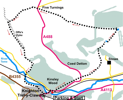
To view route as a dynamic Ordnance Survey map click here. Introduction: I should perhaps call this walk a walk of two countries as although this walk technically starts in Powys, Wales, in fact the vast majority of it is in Shropshire. The reason for doing this walk at all, was to see Offa's Dyke (first time for me). Knighton is the only town actually on the Dyke and it provided a convenient parking spot. Offa’s Dyke was built by King Offal of Mercia in the 8th Century and comprised an earthwork rampart on the English side and a ditch on the Welsh side. The present day English/Welsh border more or less follows its line. Originally, it was probably around 27 metres wide with an 8 metre drop into the ditch but the part I saw is now badly eroded, though after 1300 years or so it is only to be expected! A 177 mile National Path follows the course of the Dyke and part of my walk is along a small part of it. As you climb a track at Holloway Rocks, there are good views to the South-East behind you and as you reach the small plateau above them, there are good views to the North. The final section of the walk, as you follow Offa’s Dyke, offers super views along the lovely Teme valley. Knighton has some half timbered buildings and narrow streets. Bizarrely, although the town itself is in Wales, its railway station is in Shropshire. Towards the end of the walk, you pass a small footbridge where a line denoting the border has been painted to allow for the obligatory “foot in two countries” photo opportunity. The walk starts from the long stay car park in Knighton. Follow the A488 (Station Road) into Knighton then turn left at the junction with the A4133 (Broad Street). Turn left immediately after the filling station along Bowling Green Lane. Start: From the long stay car park, head to the town centre (signposted). Follow the main road (A488) heading for Bishop’s Castle, leaving Wales and passing the railway station. There is a footpath. Stay on the A488 as it bends after passing the station. Pass a “Welcome to Shropshire” sign. As the pavement ends, cross the road to take the obvious footpath into Kinsley Wood (SO 292724). Stay on this clear footpath until it forks, then take the right hand fork towards the road. However, just before the road, join a broad stony track and turn left for a few yards. On the right, take the path indicated by a yellow arrow, down some steps and through a kissing gate. Head towards the centre of the far field boundary, crossing a concrete bridge. Go through a kissing gate and cross straight over the road (SO 302729) to follow a blue bridleway arrow straight ahead. Follow the left hand boundary and continue to follow the bridleway through the next gate.
Keep to the right hand boundary across the next three fields, arriving at a gateway with multiple direction arrows. Keep straight ahead following the bridleway. Go through a walker’s gate on the left then head down to the left of the two cottages ahead of you. Head through the gate to the left of the cottages, then climb the field, keeping to the left of the ruined building at SO 308738.
As you near the top of the field, go through a gate on the right into the woods, once more marked with a blue bridleway arrow. Follow the path round to the left in the woods, passing through what looks like a large ditch and continuing to climb. Join a broad track and turn left through a gate. Continue to follow the broad track, ignoring a yellow arrow pointing left. The track turns right by a pond (SO 310742). The pond looked a little depleted after prolonged dry weather! Shortly after the pond, the track bends right but as it does, turn left through a walker’s gate in the top left corner of the field.
A few yards further on, turn left along a broad track. As this levels out, there are good views behind you.
At SO 314745, the track arrives at a gate where its status changes to footpath. A change to a yellow arrow indicates this. However, this arrow is a little misleading as shortly after going through the gate, you need to bear to the left of the gap between the two plantations and keeping to the left of a small pond. As with the previous pond, this was well depleted after dry weather but it is marked on the OS maps so is probably usually in clearer evidence. There are good views to the north.
As you get to the boundary of the left plantation, you will meet a broad rutted track, which is a byway (i.e. open to all traffic – although I did not see any at all) and indicated by red direction arrows on subsequent gateposts. Follow this byway to the A488 road at Five Turnings (SO 286754). You cannot go wrong as the byway is so well worn.
At the road, cross and follow the bridleway arrows. Initially, the bridleway is hedged on both sides, then opens into a large field. Head straight up the field initially towards the highest point but as you go, look out for a gap between the two banks of trees ahead. This is not easy to discern because of general gapping in the trees. From about half way up the field, you need to bear gently left. As you get closer to the trees, note that the left group is fenced off and at the fence corner is a post with a blue bridleway arrow indicating your onward route ahead (SO 279752). From the post, follow the left hand boundary, to the end of the field, where you meet a crossroads of paths. Keep straight ahead through the walker’s gate following the blue arrow. About two hundred and fifty yards further on, (SO 275749) meet another path, which is the Offa’s Dyke path. Turn left along this. It is easy to follow as the Dike itself, to your left, is the guide.
Stay on this path. It starts to descend towards some trees and Knighton is ahead. Just before you get to the trees, turn right down a steeply descending path (SO 284734) at a four way fingerpost, following a blue arrow. Continue down this path ignoring any turns off. Cut briefly through the corner of the woods as you get to the bottom, before exiting into a tarmac lane. You can either turn left along the lane into Knighton or do as I did, cross the lane and follow the fingerpost for “Knighton ½ Mile “ to follow the riverside path.
Cross the railway line and a footbridge over the River Teme then go left to follow the river, soon crossing back into Wales. Follow the path to a car park, leaving the Offa’s Dike path and passing back into Wales, where a bridge identifies the precise spot where the border is and you can take your photograph.
Keep straight ahead up the Tarmac lane from the car park, passing a graveyard on your right. Turn left after the church and on joining the main road (A488), turn left and eventually right back to the starting point. If you need to buy any hiking equipment/clothing before your trip see the Hiking Store All information on this site is given in good faith and no liability is accepted in respect of any damage, loss or injury which might result from acting on it.
| | |||||||||||||||||

.jpg)
.jpg)
.jpg)
%20Looking%20back%20to%20Knighton%20and%20Kinsley%20Wood.jpg)
%20Ruined%20cottage.jpg)
%20Pond%20near%20Holloway%20Rocks.jpg)
%20View%20SE%20from%20above%20Holloway%20Rocks.jpg)
%20View%20north%20from%20above%20Holloway%20Rocks.jpg)
%20View%20from%20the%20byway.jpg)
%20What%20remains%20of%20Offas%20Dyke.jpg)
%20View%20along%20the%20Teme%20valley.jpg)
%20River%20Teme.jpg)
%20The%20obligatory%20photo.jpg)