|
Strumble
Head
|
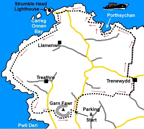
Starting
point and OS Grid reference:

Free
car park at Garn Fawr (SM 899388)
|
Ordnance
Survey Map
OL35
– North Pembrokeshire.
Buy this map from
List
of OS Maps
Note: If you use OS Maps on-line, you can download this route via this
link.
| |
Distance: 6.6 miles
| |
Traffic light rating: 
(For explanation see My
Walks page)
| |


For advice on .gpx files see
My
Walks page
|

Click
the PDF logo above to give a printable version of this walk without the
photos.
|
To
view route as a dynamic Ordnance Survey map click here.
Introduction:
This is an easy short walk to
Strumble Head, a prominent headland on the North Pembrokeshire coast
with a lighthouse on a small island Ynys Meicel linked by a bridge. You are
likely to see the ferries plying between Fishguard and Rosslare in Ireland.
There are precipitous cliffs and on the rocks below there is a chance you
may see seals. Dolphins and porpoises can also sometimes be seen.
The walk starts at the
Pembrokeshire Coast National Park free car park at Garn Fawr. Garn Fawr has
a trig. point and what is reputed to be one of the best iron age hill fort
sites in Britain.
To get there, turn off the
A487 Fishguard to St. Davids where signposted to St. Nicholas (Tremarchog).
Go through the hamlet to Harmony and turn left signposted Strumble Head.
%20Coast%20view%20with%20Strumble%20Head.jpg) Start:
Turn left out of the car park, immediately getting great views of the
sea and the lighthouse at Strumble Head. Keep on the road passing a footpath
on the left at Tarn-y-Myndd. Take the bridleway on the right about 200 yards
further on, marked with a fingerpost bearing a horse and rider. Start:
Turn left out of the car park, immediately getting great views of the
sea and the lighthouse at Strumble Head. Keep on the road passing a footpath
on the left at Tarn-y-Myndd. Take the bridleway on the right about 200 yards
further on, marked with a fingerpost bearing a horse and rider.
At a three way fingerpost,
keep straight ahead. Ignore a right turn a little further on through a gate
with a blue arrow.
You come to a footpath on
the left marked with a fingerpost but stay on the main bridleway straight
ahead, passing between two large stone gateposts. When the bridleway splits
at a ‘Y’ shaped junction, turn left.
Go through a gateway and
keep right.
The bridleway passes
between the buildings at Trenewydd into the main road. Turn left then almost
immediately right by a powerpole on to National Trust property. Although
this path is signed to indicate it is a public footpath and track to
Goodhope and Penrhyn Cottage only, perhaps suggesting that you can go no
further, in fact the track does legitimately link with the coast path. I
confirmed this with NT employees who were seen there at the time.
Immediately after the gate, the track forks but keep straight on as
indicated by the yellow footpath arrow.
You enter the National
Trust land of Goodhope at a cattle grid. The track goes over a ford where
there are stepping stones. As you pass a line of large boulders on the left
(presumably to prevent parking) look out for a finger post on the right which
is a permissive path to the coast path. Go through the gate there and turn
right.
%20looking%20west%20near%20Porthsychan.jpg)
This footpath meets the
coastal path at SM 912407. Turn left and follow the coastal path designated
by the acorn sign. You soon come to a pleasant little bay at
SM 906407 (Porthsychan) which makes a pleasant lunch stop for your
sandwiches.
%20Coast%20view.jpg)
The coast path meets the
access road to the lighthouse. Turn right and stay on the coast path (no
access to lighthouse). You pass a stone cairn overlooking the lighthouse at
SM 889406.
%20strumble%20Head.jpg)
%20Looking%20Back%20at%20Garn%20Fawr.jpg)
At SM 889394, ignore a
stile on the left marked “private”.
The coast path arrives at
Pwll Deri Youth Hostel. Turn left to the road and at the road, cross it and
take the left hand of the tarmac drives to Pwll Deri Holiday Cottages. After
Swn-y-Morli cottage, turn left and immediately right over a stile by a power
pole.
A short distance up the
hill, you come to a wooden post with faded yellow footpath arrows. Turn
right.
At a wooden stile above a
cottage with white painted chimneys, ignore it and carry straight on towards
the stone bluff in front of you.
The path does a short steep
climb behind a stone cottage before heading right to a ‘T’ junction of
footpaths. Turn right to return to the car park or left, should you wish to
inspect the Iron Age hill fort and trig point first – it is no more than
300 yards or so.
If you need to buy any hiking
equipment/clothing before your trip see the Hiking
Store
All information on this
site is given in good faith and no liability is accepted in respect of any
damage, loss or injury which might result from acting on it.
|


.jpg)
.jpg)
.jpg)