|
St
David's Head
|
Starting
point and OS Grid reference:

Roadside parking by St David's City Golf Course
(SM 741270)
|
Ordnance
Survey Map
OL35
– North Pembrokeshire.
Buy this map from
List
of OS Maps
Note: If you use OS Maps on-line, you can download this route via this
link.
| |
Distance: 6.9
miles
| |
Traffic light rating:

(For explanation see My
Walks page)
| |


For advice on .gpx files see
My
Walks page
|

Click
the PDF logo above to give a printable version of this walk without the
photos.
|
To
view route as a dynamic Ordnance Survey map click here.
Introduction:
This walk takes you to the summit of
Carn Llidi - but do not panic it is only 181 metres high! However despite
its low altitude, there are extensive views across to the Preseli
Mountains, along the coast and Whitesands Bay (Porth Mawr in Welsh). There
are remains of ancient burial chambers though they take some spotting. I
photographed what I think was one then gave up! The walk overall is a very
easy 6.9 miles hence the green traffic lights. There is one small section to
the site of the trig point which involves a short scramble up rocks but to
be honest although I did this to photograph the trig point, there are only
rusty bolts remaining so purely for the view, there is not much gain from
the more accessible ground. It is up to you!
Refreshments and toilets
are available at Whitesands Bay and I can recommend the ice cream from the
shop.
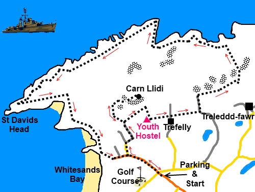
The walk starts from a
small amount of rough roadside parking just before the entrance to St David's
City Golf Course. The only other alternative because of the narrow roads is
to use the pay car park at Whitesands Bay. The parking is on the B4583 from
the city of St Davids.
Start:
Start by walking down the road from the rough parking. Ignore the first
right for the Youth Hostel and take the next on the right, an unsigned no
through road just before the camp site.
The tarmac road becomes a
farm track curving to the right and there is a public footpath finger post
indicating the route. Follow the track through a gate on to National Trust
Land and at a junction of paths, turn left.
Carn%20Llidi.jpg)
Just past a large rock on
the left hand side of the track, take the right hand fork. As you pass
between two metal posts on a concrete section of the path, look right and
you can see what I believed to be a burial chamber (see photo).
%20Burial%20Chamber.jpg)
To get to the summit of
Carn Llidi, as the concrete path turns right up concrete steps bear left and
follow the path. Incidentally, the view from the top of the steps at some
old military remains is nearly as good with fine vistas of Whitesands Bay
and Ramsey Island offshore.
%20Whitesands%20Bay.jpg)
%20Looking%20NE%20from%20Carn%20Llidi.jpg)
Retrace your steps to the
three way fingerpost and turn left. The path takes a level route around the
hill following its contours, with a fence on the right. As it meets another
three way fingerpost, turn right through the kissing gate,
At the Youth Hostel, turn
left just after it where indicated by the fingerpost and yellow footpath
arrow.
After crossing three
stiles, you should be on the track leading from Trefelly. Continue straight
ahead over another stile.
After crossing two fields
you arrive at a four way fingerpost just before a ruined building. Turn left
on the old track. Continue on this passing a gate either side into the
fields until the track ends at a ‘T’ junction of paths where you go
through the walker’s gate and turn right.
Keep on this track ignoring
any turn off until you come to a gate on the right rising from
Treleddyd-fawr. Turn left here and keep straight ahead for the coast.
You arrive at the coast
path at OS reference SM 750287. I was fortunate enough to see a large male
(I think) seal on the rocks below here. Turn left and follow the coast path.
%20Looking%20NE%20Near%20Porth-gwyn.jpg)
%20Seal.JPG)
At a fork with two wide
grassy tracks (SM 733286), keep right.
At SM 729284 join another
footpath and turn right and shortly afterwards, fork right again.
%20Cairn%20and%20Ramsey%20Island.jpg)
At the cairn, head for the
headland which is St David's Head (Penmaen Dewi), straight ahead. The final
approach involves an easy meander between and across rocks. You end up at a
rocky promontory overlooking the point itself (up to you if you descend –
I didn’t).
%20St%20Davids%20Head.jpg)
Whitesands Bay is visible
to the left. Simply follow the obvious path along the coast to reach it.
Turn left when you get there to follow the road back to your starting point.
If you need to buy any hiking
equipment/clothing before your trip see the Hiking
Store
All information on this
site is given in good faith and no liability is accepted in respect of any
damage, loss or injury which might result from acting on it.
|


.jpg)
.jpg)
.jpg)