|
Parkhouse
Hill and Chrome Hill
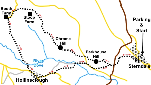
Starting point and OS Grid reference:

Village road parking outside St
Michael and All Angels Church, Earl Sterndale (SK 091670)
|
Ordnance Survey Map
OL24
The Peak District - White Peak area.
Buy this map from
List
of OS Maps
.Note: If you use OS Maps on-line, you can download this route via this
link.
| |
Distance: 5.3 miles
|
Date of Walk: 22
April 2015
| |
Ascent:
Descent:
See Walking Time Calculator
|
1418ft (432m)
1421ft (433m)
| |
Traffic
light rating:  
(For explanation see My
Walks page)
| |


For advice on .gpx files see
My Walks page
|

Click
the PDF logo above to give a printable version of this walk without the
photos.
|
To
view route as a dynamic Ordnance Survey map click here.
Introduction: This walk to Parkhouse
Hill and Chrome Hill provides an exciting ridge walk (two ridges really)
with brilliant far reaching views. The hills are spectacular limestone
promontories to the north of the River Dove and were coral reefs on the edge
of a lagoon millions of years ago, in the Carboniferous Period.
The hills are designated a Site of Special
Scientific Interest by reason of the wide range of limestone flora,
including the rare Jacob’s Ladder (Polemonium caeruleum).
The route is not likely to be picked up by
casual scanning of an OS map as no rights of way are marked over the
summits. However, they are within Access Land and there are concessionary
paths. In places, the precise route may not be defined by worn turf but it
is not difficult to work out the access to the clearer worn areas.
The walk should not be underestimated, as
there are very steep descents from both summits but especially from
Parkhouse Hill, hence the red traffic light. Because the rock is limestone,
I would not recommend the walk during or immediately after wet weather as it
is likely to be treacherously slippery underfoot.
The walk starts at the village of Earl
Sterndale, where there is roadside parking on a side road next to the church
and a handy seat for boot changing.
The easiest way to describe the route to get
to Earl Sterndale, is to turn south off the A515, about 3 miles south-east
of Buxton, on to the B5053 signed for Longnor. Follow the B5053 for 1½
miles to a crossroads then turn left for Earl Sterndale (signed). From any
other direction consult at atlas or use sat nav. Good luck!
There are no facilities en route but good
picnic spots at the top of both hills.
Start: From
the church (SK 091670), cross the road and take the footpath across the road
from the post box. Note there are two paths here and you want the one off to
the right
After two walkers’ gates, cross a larger
field, head towards the sharp pointed hill ahead (which is Parkhouse Hill).
Cross a stile by a gateway and water trough. A kissing gate is then visible
ahead. Through this, head downhill, initially in the direction of some barns
across the valley but then swinging left to a stile.
%20Parkhouse%20Hill%20and%20Chrome%20Hill.jpg)
Cross this stile then head downhill at about
45°, to the road (SK 085668). Cross the road and the onward route is clear,
to a gate at the foot of Parkhouse Hill.
As you look up the hill, the worn footpath
can be made out. However initially, head anti-clockwise round the hill for
100 yards or so, before zigzagging back. You need to look carefully for the
slightly trampled path. This evens out the slope. Once you start the more
direct ascent, the route created by others becomes clear.
There are no cairns/trig points to indicate
the summit but there is no doubting when you reach it (SK 078669)!
%20Summit%20of%20Parkhouse%20Hill.jpg)
%20View%20back%20to%20earl%20Sterndale%20from%20Parkhouse%20hill.jpg)
%20Panoramic%20view%20south%20from%20Parkhouse%20Hill.jpg)
%20View%20back%20along%20the%20ridge%20from%20Parkhouse%20Hill.jpg)
Continue ahead along the ridge (279°),
towards Chrome Hill directly ahead. The path descends very steeply in places
and there are some vertical drops so take care. As you descend, you will
reach a point (SK 078670) where the path seems to divide and you may be
unsure whether to go left or right to complete the descent. The right hand
path is the way to go. I would mention here that two walkers watched our
descent and when we arrived at the bottom, they said they had taken the left
path, which was horrendous and potentially dangerous and that we had
definitely taken the best route. So, be warned!
At the road, turn right then left over the
stile (SK 077671) just before the cattle grid for the path up Chrome Hill.
%20Parkhouse%20Hill%20from%20start%20of%20Chrome%20Hill.jpg)
You go through a kissing gate, passing a
memorial to Bill Etches of Dowall Hall, the building directly below. The
route is not defined but is straight up the hill and a more specific path
appears as you ascend.
%20Parkhouse%20Hill%20Ridge.jpg)
Again, there is no summit marker.
%20Summit%20of%20Chrome%20Hill.jpg)
%20View%20SW%20to%20Hollinsclough.jpg)
%20Portal%20on%20Chrome%20Hill.jpg)
Continue along the ridge (310°) and descend
the end to a kissing gate. Go straight ahead through this, following the
obvious path.
%20Chrome%20Hill%20ridge%20on%20descent.jpg)
At a walkers’ gate, turn right following
the Concessionary Path fingerpost.
%20Chrome%20Hill.jpg)
At the top of the grassy hill, bear left
through a gate then follow the right hand boundary through the next couple
of fields. You reach a broad track and a three way fingerpost (SK 065682).
Follow the direction to Booth Farm, to the gate you can see at the far side
of the next field. Another fingerpost here confirms your onward direction.
Continue in the same direction until you
reach a broad track by two sets of gates. Turn right then left at a tarmac
lane towards Booth Farm.
When the tarmac turns right to the farm, head
off to the left along a broad track (SK 059681).
Just after a stone cottage, the track
divides. Take the right fork (descending).
When the track divides again, once more, go
right.
Pass an entrance to private land and ignore a
path off to the right, going back on yourself.
Your route turns right through a gate and
immediately over a bridge (SK 063669), before turning left.
%20Profile%20View%20of%20Chrome%20Hill.jpg)
When the path emerges on to a road, turn left
into Hollinsclough. Turn left at the road junction.
Walk along the road for about a quarter of a
mile. Look out for a stone barn on the left and on a bend. About a hundred
yards after this, cross the stream via a bridge and through a stile (SK
070667). Bear right and follow the left hand bank of the stream.
Stay with the stream until you come to a
footbridge next to a ford (ignore a broad crossing into a field before
this).
At a junction of tracks, keep left and go
through the large gateposts. On reaching a tarmac lane, turn right.
%20Profile%20View%20of%20Parkhouse%20Hill.jpg)
A few yards along the road, come to two
separate fingerposts (SK079668). Turn off the lane to follow the left
pointing finger. A specific trodden path may be very faint.
At a double walkers’ gate, go straight
ahead, to reach the road at the point where you started the ascent of
Parkhouse Hill. Retrace your steps back to Earl Sterndale.
If you need to buy any
hiking equipment/clothing before your trip see the Hiking
Store
All information on this
site is given in good faith and no liability is accepted in respect of any
damage, loss or injury which might result from acting on it.
|


.jpg)
.jpg)
.jpg)