|
Hartington
to Beresford Dale, Wolfscote Dale and Biggin Dale
Starting point and OS Grid reference:

Hartington
– on street or (expensive) pay and display car park (SK 127602)
|
Ordnance Survey Map
OL
24 The Peak District – White Peak area.
Buy this map from
List
of OS Maps
Note: If you use OS Maps on-line, you can download this route via this
link.
| |
Distance: 9.3
miles
|
Date of Walk: 21
April 2015
| |
Ascent:
Descent:
See Walking Time Calculator
|
1915ft (584m)
1912ft (583m)
| |
Traffic
light rating: 

(For explanation see My
Walks page)
| |


For advice on .gpx files see
My Walks page
|

Click
the PDF logo above to give a printable version of this walk without the
photos.
|
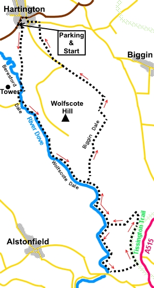 Introduction: This
walk from Hartington takes you along three lovely Derbyshire Dales. In some
ways, I think this is a more attractive walk than the more famous Dovedale,
not least because it is not quite as well known and so is not as busy with
visitors! There is a distinct contrast between the pretty Beresford and
Wolfscote Dales, which follow the River Dove and the rugged Biggin Dale with
its impressive screes.
Introduction: This
walk from Hartington takes you along three lovely Derbyshire Dales. In some
ways, I think this is a more attractive walk than the more famous Dovedale,
not least because it is not quite as well known and so is not as busy with
visitors! There is a distinct contrast between the pretty Beresford and
Wolfscote Dales, which follow the River Dove and the rugged Biggin Dale with
its impressive screes.
The route is in a figure of eight so if
desired, the last loop could be omitted, reducing the overall length by 3.5
miles or so, although this would omit a short section along the Tissington
Trail from where there are good views.
The walk starts in Beresford Dale which runs
between limestone cliffs. High above on the right is a tower, the last
remnant of the old Beresford Hall.
As it transitions to Wolfscote Dale, the
route opens up a little, before progressing between dramatic limestone
outcrops. According to legend, the last wolf in the area was killed in this
Dale but this might be “pinch of salt” stuff!
The river here has many weirs along its
length providing areas popular with fishermen. Indeed, Izaak Walton, who
wrote the famous book about 17th century rural England called ‘The
Compleat Angler’ and was a friend of Charles Cotton who lived at Beresford
Hall.
Unlike the other two dales, Biggin Dale is a
dry stony valley. Dramatic screes tumble down the sides.
The circular walk ends back in the attractive
village of Hartington with a choice of pubs/cafes and public toilets.
To
view route as a dynamic Ordnance Survey
map click here.
To get to Hartington, take the B 5054 west
off the A 515, between Buxton and Ashbourne.
Start:
Exit the car park and turn left (SK 127602). At the public toilets on the
right, turn up the left hand side of the toilets. There is a large footpath
sign but it is still easy to miss this turn.
Behind the toilets, go through a walkers’
gate on to a clearly defined footpath. Follow it to another walkers’ gate
to a broad track. Go straight over it and through another gate.
%20View%20on%20descent%20to%20Beresford%20dale.jpg)
%20Tower%20above%20Beresford%20dale.jpg)
The path descends gently passing through
Morson Wood. As you reach the river, cross a footbridge, noting the rock
pillar in the middle of the river (SK 129589).
%20Rock%20Pillar%20in%20Beresford%20dale.jpg)
At the second footbridge by a ford, cross to
the opposite side.
At the third footbridge, do not cross but
stay on the left hand bank. The bridge is marked as part of the cycle
network.
At a three way fingerpost, keep straight on
for “Milldale 2¼ miles”.
%20River%20Dove%20in%20Wolfscote%20Dale.jpg)
%20Rocky%20Outcrops%20in%20Wolfscote%20Dale.jpg)
%20River%20Dove%20and%20screes%20in%20Wolfscote%20Dale.jpg)
%20Blackthorn%20Bushes%20in%20Wolfscote%20Dale.jpg)
Pass and ignore Gipsy Bank Bridge.
Just beyond it, at Iron Tors, is an old pump house containing the
remains of a ram pump used to supply farms with water from the river.
Pass and ignore Coldeaton Bridge.
%20Wolfscote%20Dale%20near%20Biggin%20Dale%20turn.jpg)
At a four way fingerpost by an old restored
pump house, keep straight ahead for “Milldale 1½ miles”
(SK 142570). Note the route signed “Tissington Trail 1 mile” to the left
will be your return route from the loop you now start.
At SK146552 you reach two houses below a
wood. Turn left here to follow the wall at the left hand side of the wood.
The path climbs steeply.
At the top of the trees, go over a gated
stile and continue straight ahead following the direction of the yellow
arrow. The next stile soon appears.
As you reach the brow of the hill, you can
see the old railway embankment along which runs the Tissington Trail. You
may be able to make out a fingerpost. Ascend to the Trail, via a walkers'
gate just to the right of the arch and turn left (SK 152553).
%20View%20from%20the%20Tissington%20Trail.jpg)
There are good views from this elevated
section of the Trail, especially to the west.
Walk along the Tissington Trail for half a
mile and just before a bridge over a track, fork left to follow the public
footpath fingerpost (SK 152561). At the bottom of the embankment, go through
a walkers’ gate, then left entering National Trust land Bradburys Bank.
Keep straight ahead following the direction
in which you descended the embankment and arrive at a kissing gate. Follow
the direction of the yellow arrow, descending into the little valley. Turn
left in the valley bottom, following a public footpath fingerpost. Ignore
the gate by the fingerpost SK152564).
%20Descending%20back%20to%20Wolfscote%20Dale.jpg)
The grassy path takes you back to the
restored pump house encountered on the outward journey. Turn right here and
retrace your steps along the river to the turn for Biggin Dale. Go right
following the fingerpost for “Biggin”.
%20Start%20of%20Biggin%20Dale.jpg)
There are some spectacular scree slopes
alongside the path along this valley.
%20Biggin%20Dale%20Scree.jpg)
%20Upper%20part%20of%20Biggin%20Dale.jpg)
When you get to a farm gate, go through it
and follow the path on the right hand side of the wall.
At the top of Biggin Dale, you reach a three
way fingerpost, at a junction of dales. Turn left for Hartington (SK
145588).
Follow the valley bottom for no more than a
hundred yards or so the take the narrow path to the left climbing the valley
side (SK 144589). There is a fingerpost indicating Hartington once more.
A short steep climb takes you to a walled
lane, where the terrain starts to level out, which you follow to a tarmac
road. Turn right here and follow the road back to Hartington. There are good
views over Wolfscote Dale along this road.
%20Return%20to%20Hartington.jpg)
If you need to buy any
hiking equipment/clothing before your trip see the Hiking
Store
All information on this
site is given in good faith and no liability is accepted in respect of any
damage, loss or injury which might result from acting on it.
|


.jpg)
.jpg)
.jpg)