
|
|
|
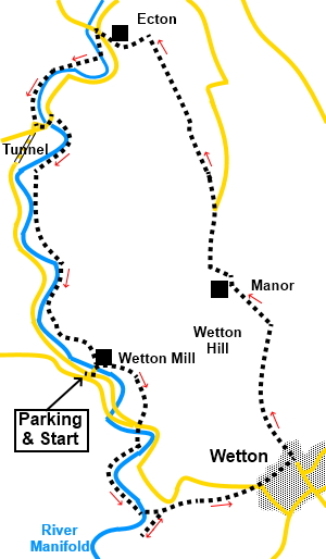
To view route as a dynamic Ordnance Survey map click here. Introduction: This walk explores part of the Manifold Way and the large dramatic Thor’s Cave, returning via Ecton Hill with great views en route. The Manifold Valley was the route of the Leek and Manifold Light Railway. This was a narrow gauge railway (2’ 6”) which transported produce and passengers to link up with the standard gauge railway. It ran from Hulme End to Waterhouses and had a station for Thor’s Cave, which was popular with Victorian tourists. In consequence, there is a very clear, if steep, path to the cave up a considerable number of steps. It is a bit of a scramble up into the cave but it is worth the effort. Be careful if wet as limestone can then be slippery Thor’s Cave is a huge cave set in a limestone cliff and formed by the effects of wind and water over thousands of years. Its name may be a corruption of ‘tors’ (meaning hills) or stem from Thor, the Norse god of thunder. Unbelievably, if you go back sufficient millions of years, this location was at the equator and the cliff would have been a submerged reef. The cave was the site of a Bronze Age burial. After passing through the village of Wetton, the route climbs to Ecton Hill, passing the remains of copper mining and later, the Ecton Mine engine house. At first glance as you approach, it looks like a barn but on closer inspection, there is the stump of a chimney and some huge concrete slabs covering the 400 metre shaft itself. The mine belonged to the Duke of Devonshire and at its peak, was one of the most advanced and productive copper mines in the World, employing around 400 people. It ceased production in 1889. Information boards on site tell you more. The walk starts from a free car park at Wetton Mill. There are various ways of getting there, depending on where you are coming from but I approached from the B5053, turning east off it, between Onecoat and Warslow, to Butterton. Once through Butterton, fork right to Wetton Mill down a single track road. Left at the first junction takes you to the rough parking area. Start: From the parking, walk back to the cross roads, then left over the river bridge. Walk into the yard at Wetton Mill, then half way through it, turn left to follow the sign on the building and follow the climbing path. As you come out of the trees, there is a post with yellow footpath arrows. Follow the arrow pointing left. The path curves in a clockwise direction and drops to the floor of a small valley. Follow the valley floor to the road and cross straight over, crossing a footbridge to follow a tarmac footpath signed with a white arrow on a blue background for the South Peak Loop.
You soon pass below the towering cliffs of Ossams Hill and the limestone peak containing Thor’s Cave soon appears. As you get nearer to it, look out for a footbridge on the left and cross this, passing an information board about the cave. Follow the broad, rising path through the trees. Avoid any tempting earth paths heading up through the trees and keep going until you reach some broad stone steps on the right. Turn right here up to the cave (SK 100551).
After the cave, retrace your steps to the path you left and turn right. After leaving the trees, through a walkers’ gate, you enter a small valley. Follow this to the road and turn right. Keep left at the fork in the road. Walk through the village, passing the village hall and art hr road bends right by the telephone box, turn left to follow a sign for “Back of Ecton” (SK 109555). Almost immediately, ignore a footpath off to the right. Stay on the broad track, passing a small covered reservoir on the right and as it bends left at an old quarry, branch off through a slit stile, following a white arrow (or possibly a faded yellow arrow – difficult to tell).
You enter the National Trust property of Wetton Hill. Follow the obvious path. It drops down to a stile which you cross. Keep straight ahead.
Arrive at another stile cross this but ignore the stone stile immediately on the left and follow the wall as it curves left down to a small stream, at the Manor House. Cross the stream via stone slabs and at the drive, turn right to follow it. The drive merges with a tarmac road. Continue to follow it, initially following some power lines on the left before passing underneath them. Arrive at a junction, where the road branches right downhill. Keep left here, uphill (SK 104572).
About a hundred yards after the junction, turn right to follow a public footpath fingerpost. You will soon come in sight of old copper mines spoil heap. Keep on the path to the left of this and at a multi-way fingerpost, follow the concessionary path to the trig. point on Ecton Hill (SK 100580) which should now be visible on the near horizon.
Continue beyond the trig. point and at the top of a steep drop down to the Manifold Valley and Ecton, with the bright green copper verdigris spire of a large house visible, turn right to follow a well trodden path. Cross a dilapidated wall and continue downhill following the wall on the left, soon turning left through a gated stile. Arrive at an enclosure in which sits the old Ecton Copper Mine engine house, looking like a barn. Follow the enclosure round and go through a walkers’ gate. Access to the engine house enclosure and the information boards is left but the route continues right through the walkers’ gate. Follow the wall down as it curves left, passing the old gunpowder store.
Beyond this, you arrive at a gate by the interesting house with the copper verdigris spire. Go through the gate and follow its drive down to the road. Turn right for a few yards then go left and left again (before crossing the road bridge) to follow the sign for the National Cycle Network. You arrive at the road, opposite the road tunnel. You can go through the tunnel and just follow the road back to the parking area but I opted to not go through the tunnel but to follow a track at the other side of the river to avoid traffic. The directions for this seem counterintuitive because of the road layout but at the tunnel entrance, turn left along the road. At the road junction, go left again. Cross the river bridge then immediately right along a broad track, through a metal gate.
You now follow this track back to Wetton Mill, passing the entrance to an old mine at SK 093576. At a ‘T’ junction of paths at Dale Farm, turn right then right again at the mill, to return to the parking area.
If you need to buy any hiking equipment/clothing before your trip see the Hiking Store All information on this site is given in good faith and no liability is accepted in respect of any damage, loss or injury which might result from acting on it.
| | |||||||||||||||||

.jpg)
.jpg)
.jpg)
%20Manifold%20Way%20and%20crags%20of%20Ossoms%20Hill.jpg)
%20Entrance%20to%20Thors%20Cave.jpg)
%20View%20from%20Thors%20Cave.jpg)
%20Dark%20Recess%20of%20Thors%20Cave.jpg)
%20Window%20in%20Thors%20Cave.jpg)
%20View%20west%20on%20leaving%20Wetton.jpg)
%20View%20North%20By%20Wetton%20Hill.jpg)
%20View%20east%20from%20Ecton%20Hill.jpg)
%20View%20back%20to%20Wetton%20Hill.jpg)
%20Cow%20in%20field.jpg)
%20Trig%20point%20on%20Ecton%20Hill.jpg)
%20View%20to%20Ecton%20and%20Manifold%20Valley.jpg)
%20Gunpowder%20store%20for%20Ecton%20Copper%20Mine.jpg)
%20First%20signs%20of%20autumn.jpg)
%20Road%20tunnel%20near%20Ecton%20bridge.jpg)
%20Disused%20mine%20entrance.jpg)
%20View%20Near%20Wetton%20Mill.jpg)