
|
|
|
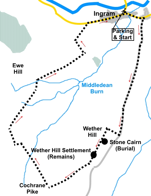
To view route as a dynamic Ordnance Survey map click here. Introduction: This short walk to Wether Hill and Cochrane Pike provides for lovely views over the tranquil Ingram Valley, although it was a little hazy when I did the route. There is also plenty of evidence of Bronze/Iron Age activity. On Wether Hill is a perfectly round stone cairn, thought to be the remains of a robbed out Bronze Age burial mound. Close to it, excavations indicated there had been an Iron Age settlement. A coffin has been found with the remains of five Bronze Age pots. From Wether Hill, the route continues towards Cochrane Pike passing directly through Wether Hill’s very well preserved remains of settlement embankments, possibly dating to the Bronze Age. Evidence of hut circles has been found here. There is a moderate ascent to the summits and an equally moderate descent. The walk starts at a free car park on the outskirts of Ingram village, by a telephone box. The road is a dead end and the only way to drive there is to turn west off the A697 Morpeth to Wooler Road. I used the road seven and a half miles south of Wooler, which is signposted for Ingram. Park in the car park, immediately after crossing the river bridge. Start: Turn left out of the car park (NU 0171630) and quickly turn left again following the sign for “Ingram Mill ½ mile” and a fingerpost for “St Michael And All Angels’ Church 380 metres”. Just before Ingram village hall and opposite Cheviot Holiday Cottages turn right along a broad track, leaving the tarmac behind. It is signed as a public byway to Prendwick.
Continue along this track for a mile and a quarter, turning right at the end of the first field, after going through the first of two gates (these are close together), following the white arrow. Continue to follow it as it bends left.
The next turn is difficult to spot. Stay on the track as it gently bends right. Before reaching the brow of the hill, fork off to the right, following a faint path to the top of the hill (NU 0164114677). I give the precise OS reference in case you are using a GPS receiver but basically if you head for the top of the immediate hill on the right, you will not be far out but if you can follow my direction, you will not miss the almost perfectly circular stone cairn (a robbed out burial) with a visible circle of stones in the turf around it, perhaps the remains of a wall. Having turned right, you should soon see a broad ditch, possibly part of ancient earthworks. To the left is the top of Cochrane Pike, the next destination.
Follow the ditch to the top and look out for a faint path where you turn left towards Cochrane Pike. At NU 0146514608, you will pass the cairn circle of stones referred to above.
Continue towards the top of Cochrane Pike, passing through the clearly visible remains of the ramparts of a settlement/hill fort (NU 01313 14438). Walk straight through the settlement to join another clear path heading to the top of the Pike.
You will come to a marker post for the Hillfort Trail. Bear right here following the direction of the white arrow (NU 010141). You soon pass another white arrow and continue to follow its direction. Just after crossing the top of Cochrane Pike, arrive at another marker post with various arrows. Turn right here to follow a faint path dropping down towards the valley (NU 007140). Descend into a small valley and up the other side, ignoring a path off to the right. At the top of the banking, turn left to follow the fence to a corner, where you turn right at 90°. At a multi-way fingerpost, turn right over a stile, leaving Access Land (NU 002148), to follow the path to the end of the woodland. Just past the end of the woodland, cross another stile to re-enter Access Land and follow the obvious path downhill.
At NU 004151, the track forks. Keep left. At the next junction of paths, marked with a multi-arrowed post, turn right following the white arrow. Join a broad stony track. To the right, it goes to a house but you keep left.
The track drops to the road where you turn right to return to the car. Before doing this however, no more than a third of a mile left along the road is the Bulby's Wood Information Centre where there are toilets too. If you need to buy any hiking equipment/clothing before your trip see the Hiking Store All information on this site is given in good faith and no liability is accepted in respect of any damage, loss or injury which might result from acting on it.
| | |||||||||||||||||

.jpg)
.jpg)
.jpg)
%20View%20near%20the%20start%20of%20the%20walk.jpg)
%20View%20to%20Brough%20Law.jpg)
%20Wether%20Hill.jpg)
%20Looking%20back%20towards%20Ingram.jpg)
%20Track%20From%20Ingram.jpg)
%20View%20SW%20from%20Wether%20Hill.jpg)
%20Cairn%20on%20Wether%20Hill.jpg)
%20Part%20of%20the%20earthworks%20on%20Wether%20Hill.jpg)
%20Weather%20Hill%20with%20earthworks.jpg)
%20Descending%20back%20to%20Ingram.jpg)
%20Looking%20up%20the%20Breamish%20Valley.jpg)