
|
|
|
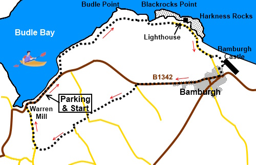
To view route as a dynamic Ordnance Survey map click here. Introduction: This is a fantastic walk along Northumberland’s coast. It starts at Waren Mill a fairly insignificant place in itself but its big plus is that it sits at the head of the beautiful Budle Bay. There was of course a mill here from about the 12th Century. In the 1700s, a more ‘modern’ water powered mill was built, the bay providing a useful sea route to move its produce (flour). It was expanded and improved through the 1800s until a fire caused a rebuild and an expansion into bone crushing! Later, it produced malt for the brewing industry which continues until the 1980s. It was then sold and eventually converted into apartments. Budle Bay is a wide flat bay, known for its beauty and bird wildlife which arrives when the tide is out, to take advantage of the mud flats. The tide was in when I set off and it certainly was stunning with a lot of cars pulled up on the lay-by with the occupants enjoying the view. When I returned, the tide was out and for me, the mud flats did not particularly appeal. The people that remained were clearly there to see the birds of which there were probably thousands! All along the route are gorgeous views of sands and interesting features such as an unusual lime kiln, Blackrocks Point lighthouse atop a small squat building built in 1910, which, if you let your imagination stretch, resembles a smiley face. There are seats here where you can watch the waves crashing in. Then you come to the magnificence of Bamburgh Castle. Built by the Normans in 1095 on the site of an earlier castle, its prominent position commanding the coastline. Parts are open to the public foe a fee. The
village of Bamburgh itself is very attractive and has a couple of nice pubs.
It is the home of the RNLI Grace Darling Museum named in honour of the lady
of that name, who became a heroine in 1838 by rowing out with her father in
rough weather to help rescue those on board the steamship Forfarshire
which was wrecked on the rocks. It is worth a visit. The village also is home to St Aidan’s
Church with an interesting crypt. Don’t miss the lovely Mediterranean garden and café accessed through a somewhat insignificant door at the side of the village green. The walk starts from a long rough lay-by at Warren Mill at the side of the road, not a dedicated car park as such. To get there, from the A1 by the village of Belford, the road to Waren Mill is signposted. Just follow the signposts and shortly after Budle Bay campsite, turn left on to the B1342 and continue until you reach a very long lay-by on the left overlooking the water. Park anywhere on here. Start: Walk east along the lay-by with the sea on your left. The lay-by leads naturally to the English Coast Path, indicated by a fingerpost, off to the left (NU 153350).
Follow the obvious path. It leads into a large field used for camping. Follow the left hand boundary to a walkers’ gate. Once through the gate, turn immediately right up a broad track then quickly left indicated by a fingerpost, then soon passing an old lime kiln.
At NU 160356 you get to heather cottages where the path drops down to the beach.
Continuing along the path. At a large clump of gorse bushes (NU 156355) the path divides. The left hand arm goes a short distance to a viewpoint overlooking an old pier. You also soon come across a ruin of what was probably part of a system to deliver stone to the pier. Further on is an old WW II Hotchkiss gun emplacement (NU 161358).
You will soon come to a golf course. The path starts hugging the left hand boundary before crossing a stony path section. It soon moves further into the gold course than might feel comfortable but the route is clearly marked with yellow arrows on posts. The path across the golf course ends at the club house where you exit via a white painted walkers’ gate along its drive.
At Blackrocks point there is the lighthouse (NU 175359.
Either follow the lane into Bamburgh or you can do as I did which was to turn left immediately after the first building you come to on the left, following a fingerpost for “English Coast Path”. This takes you to beneath the castle for a closer view, where a right turn at a wide stretch of sand takes you to the village. Follow the path either side of the cricket field to the road and turn right.
In the village, take the road to the right of the village green signposted for Belford. You pass St Aidan’s Church and the Grace Darling Museum.
Initially, there is a pavement but when this runs out, There is a grass verge of varying width, though mostly quite wide. This is a fast road so take care. Follow the road for just under a mile. When you reach a minor road off to the left, turn along it for a few yards then turn right through a kissing gate. Cross the field to its highest point then turn left to follow its boundary.
At the end of the field, the path continues in the field on the right, following the left hand side on the slightly raised ground. After crossing a stile, follow the left hand boundary. At the road turn left then right to Waren Caravan Site. When you reach the site, go through the walkers gate at the side of its main gate to follow the fingerpost for “Spindlestone Mill ¾ Mile”. The path goes to the left of the buildings to join the site’s internal road. Turn left to follow it. When the road bends sharply right, at the far side of the site, branch off left through a walkers’ gate then turn right. At the end of the field, the path passes downhill through some pleasant woodland below Spindlestone Heughs, a rocky cliff. At the bottom of the hill, note the path goes through the gate and to the left of the fence beyond, not continuing through the woods as a worn path might indicate. The path exits into a lane where you turn right to follow it back to Waren Mill. If you need to buy any hiking equipment/clothing before your trip see the Hiking Store All information on this site is given in good faith and no liability is accepted in respect of any damage, loss or injury which might result from acting on it.
| | |||||||||||||||||

.jpg)
.jpg)
.jpg)
%20View%20over%20Budle%20Bay.jpg)
%20Lime%20Kiln.jpg)
%20Part%20of%20Budle%20Bay.jpg)
%20Budle%20Point%20and%20pier.jpg)
%20Ruin%20at%20Heather%20Cottages.jpg)
%20Gun%20Emplacement.jpg)
%20Sandbar%20at%20edge%20of%20Budle%20Bay.jpg)
%20Sandy%20bay%20before%20Blackrocks%20point.jpg)
%20Lighthouse%20at%20Blackrocks%20Point.jpg)
%20View%20to%20Bamburgh%20Castle.jpg)
%20Bamburgh%20Castle.jpg)
%20Bamburgh%20Castle%20across%20the%20cricket%20field.jpg)
%20St%20Aidan's%20Church.jpg)
%20View%20back%20to%20Bamburgh%20Castle.jpg)