
|
|
|
Introduction:
This easy walk along the banks of the River South Tyne
takes you past the impressive Featherstone Castle and to the spectacular
Lambley Viaduct, passing through the village of Lambley with its attractive
church en route. Featherstone
Castle is a private residence. Its origins date back to the 14th century and
a tower built by Thomas de Featherstonehaugh.
It has since had many additions and alterations and a varied history,
including having its grounds used as a camp for training American troops in
WWII and then a Prisoner of War camp. You may note some derelict, brick
buildings on the far side of the river after passing the castle. Like all
good castles, it has ghosts, the ethereal remnants of a wedding party in the
17th century where a fight led to many being killed. Lambley
church was built in 1885 on the site of an older church in such poor repair,
that daylight could be seen between the stones. Lambley
Viaduct is a truly impressive structure towering above the River South Tyne.
It was built in 1852 by the Newcastle and Carlisle Railway and in use until
1976. It carried the Alston branch line from Haltwhistle. It has 9 arches,
each 56 ft wide and crosses 105 ft above the river. There are therefore
great views from the top.
To
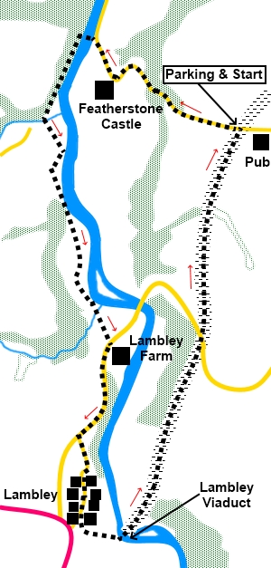
view route as a dynamic Start:
From the car park, climb the steps and cross the old railway line (which
will be your return route) to the road. Turn left along the road. Continue
along the road (Hall Bank) from which there are good views both north and
south. It drops down, passing Featherstone Castle. When you reach the river,
cross the footbridge and turn left, to walk along the right hand river bank.
At
NY 671610, the path turns away from the river and crosses another
footbridge, over Hartley Burn. Immediately after crossing the footbridge,
turn left to follow the burn. In
the field you come to, head diagonally across the field to reach the river
and turn right to follow it. The
route from this point crosses pasture and is well defined with stiles, gates
and arrows. Just walk roughly parallel with the river. Eventually,
you go through a gate to join a broad track (NY 673596). Turn left and
follow it to the road, by Lambley Farm. At the road, turn right. Follow
the road for just less than half a mile. Turn left on to a minor road,
signposted to Lambley (NY 672590). Follow
the road over the bridge into Lambley village. Just after a house on the
right called Harpertown, there is a footpath on the left which will take you
to the viaduct directly. However, I chose to walk through the village,
partly just out of curiosity but also to look at the church (St. Mary and
St. Patrick). Assuming you do the same, carry on through the village. As you
leave it, it climbs gently. About fifty yards before joining the A689, turn
left along a footpath indicated by the fingerpost for “Lambley Viaduct ¼
mile” and “Coanwood 1 mile”.
Follow the footpath downhill. After going through a gate, descend steps close to the viaduct. Turn right at a four way fingerpost following the sign for “South Tyne Trail (North) via Lambley Viaduct.
The
remainder of the route is simply following the course of the old railway
back to the car park, a distance of just over one and a half miles. If you need to buy any hiking equipment/clothing before your trip see the Hiking Store All information on this site is given in good faith and no liability is accepted in respect of any damage, loss or injury which might result from acting on it.
| | |||||||||||||||||

.jpg)
.jpg)
.jpg)
%20View%20South%20From%20Hall%20Bank.jpg)
%20Molecatchers%20work.jpg)
%20Trees%20with%20spring%20colours.jpg)
%20View%20over%20Featherstone%20Castle%20to%20the%20Tindale%20Fells.jpg)
%20Featherstone%20footbridge.jpg)
%20View%20From%20Featherstone%20Footbridge.jpg)
%20Featherstone%20Castle.jpg)
%20Bluebells%20in%20Crew%20Wood.jpg)
%20Featherstone%20River%20Flow%20Gauging%20Station.jpg)
%20Parish%20church%20of%20St%20Mary%20and%20St%20Patrick%20Lambley.jpg)
%20Lambley%20viaduct.jpg)
%20Looking%20along%20Lambley%20viaduct.jpg)
%20View%20north%20from%20Lambley%20Viaduct.jpg)
%20View%20south%20from%20Lambley%20Viaduct.jpg)
%20Old%20buffer.jpg)
%20Artwork%20neaR%20Coanwood.jpg)