
|
|
|
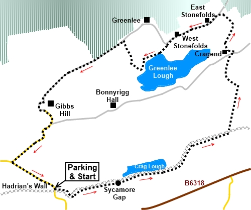
To view route as a dynamic Ordnance Survey map click here. Introduction: This walk takes you along what is reputedly one of the most scenic sections of Hadrian’s Wall with dramatic views to Crag Lough and passing the now famous Sycamore Gap before heading north to see Greenlee Lough. Hadrian’s Wall needs no introduction, having been commissioned by the Roman Emperor Hadrian. It runs for 73 miles between Bowness on Solway to Wallsend, near Newcastle and took 6 years to build, starting in AD122. It was originally around 3 metres high. At every mile, there was a mile castle and you will pass the clear remains of mile castle number 39. At this point, the wall runs along the top of the naturally occurring Whin Sill, a line of igneous rock running across the North Pennines. This has formed a series of rocky cliffs providing a natural barrier to the North. It is also famous because in Teesdale, the famous High Force waterfall tumbles over it. At one time it was customary for walkers to walk along the top of the wall but this is no longer tolerated due to erosion. The wall was designated as a UNESCO World Heritage Site in 1987. Sycamore Gap gained fame by having featured in the Hollywood film Robin Hood Prince of Thieves. It derived its name from a neatly placed and iconic sycamore tree at the base of this gap in the Whin Sill. It was reputedly the most photographed tree in the country. In fact it won English Tree of The Year in 2016. Unfortunately, since I did the walk, vandals took a chainsaw to the tree in late September 2023, destroying hundreds of years of history and damaging Hadrian’s Wall in the process. After a long investigation, two men were convicted of criminal damage and jailed - see BBC report. I have left the photo of the tree on the web page, “in memoriam”. I do not know when I will visit this spot again but if anyone doing this route was willing to send me a photo of the gap without the tree, I would then be able to publish “before and after” pictures. Please confirm you are happy for me to publish. The walk passes two loughs (lakes). Crag Lough and Greenlee Lough. Both are glacial lakes and Greenlee Lough is the largest in Northumberland. The walk starts from the Steel Rigg car park. To get there, simply turn north off the B6318 at Twice Brewed, six miles east of Greenhead. There is an expensive pay and display car park, where you need to accurately assess walking time with a margin for error! Start: From the car park, head towards its rear, right hand corner and follow the obvious footpath. At the end of the field, turn left through a walkers’ gate. The path then drops down a grassy bank to Hadrian’s Wall which is clearly visible. Turn left, with the wall on your right at this point (NY 753675).
Climb via the stone steps and by the time you reach the top of Peel Crags, you will have crossed the line of Hadrian’s Wall which will now be on your left.
The path follows the wall, and drops down to Mile Castle 39 (NY 760677), the outline of which is clear from above.
Climb
again and after a further relatively level section, it drops again to the
famous Sycamore Gap (NY761677).
The path then climbs again, to pass above Crag Lough, passing through trees, before dropping down to a walkers’ gate. Turn right through this and immediately left through another following the obvious path.
The path swings left to pass in front of the farm at Hotbank. The path kinks right and left, a small diversion as part of erosion management and climbs to pass between two copses of trees.
Continue following the path as it drops down to a gate and ladder stile. Cross this and follow the direction of the fingerpost for “Ludgate 7¼ miles.” The path bears off to the right and does not follow the wall. As an indication that you are on the right path, after a couple of hundred yards, there is a line of stone flags crossing a boggy section (NY 782689) Once over the stone flags, there is nothing much to indicate your direction but just continue in the same line, gently closing in with a wall to the right. Eventually, you will see a ladder stile. Cross the ladder stile and continue in more or less the same direction as you approached it. There are two yellow arrows on the stile and you should follow the direction of the one on the left. As you crest a small rise in the field, you will see a very clear track ahead which you follow. Cross another ladder stile (NY 782695) and the path bears left, leading to a broad track, Cross straight over this and go through a walkers’ gate following a fingerpost for “The Pennine Way”. You start to catch sight of Greenlee Lough to the left.
As you drop to the valley floor, the path swings right in an arc before swinging back towards the house East Stonefold. It drops to a small stream, swings left briefly, then right, to the left of a stone wall. Cross a ladder stile and turn left to follow the broad track in the direction of the fingerpost for “Greenlee” (NY 779707). Pass in front of East Stonefold and further on, at West Stonefold, circuit clockwise round the house to a ladder stile in the rear right hand corner of the plot. Cross and turn left. The path drops to a small stream and climbs to a ladder stile where there is a three way fingerpost. Here you can keep to the main track if you wish to curve right in front of Greenlee but I decided to have a closer look at the Lough, using a concessionary path marked in brown on the OS map... To do this, keep straight ahead following the fingerpost for “Bird Hide” and “Greenlee Lough”. The path follows the left boundary of the field, dropping down to some trees. The bird hide is clearly visible in the trees from which there is a good view of the Lough and any birds on it. Otherwise, the route continues along the edge of the trees, to the right of the fence.
The path becomes an extensive boardwalk, which takes you across the marshy reed beds. Follow this and when it forks, keep right (the left arm was closed when I visited anyway). The boardwalk ends at a walkers’ gate. Go through this and bear slightly left up the hill. The path was faintly visible but as a guide, when you get to a ditch, turn right to follow it. When the ditch runs out, the path becomes indistinct but if you continue in roughly the same direction, you are sure to meet a broad stony track (the one from Greenlee) (NY 763702). Turn left along it. Stay on this track and at Gibbs Hill Farm, it becomes a tarmac road. Follow the road and at a ‘T’ junction, turn left along that road. Half a mile later, you will arrive back at the car park. If you need to buy any hiking equipment/clothing before your trip see the Hiking Store All information on this site is given in good faith and no liability is accepted in respect of any damage, loss or injury which might result from acting on it.
| | |||||||||||||||||

.jpg)
.jpg)
.jpg)
%20Peel%20Crags%20with%20Crag%20Lough.jpg)
%20Descending%20to%20Hadrians%20Wall.jpg)
%20View%20SW%20from%20Steel%20Rigg%20with%20mile%20castle%2040.jpg)
%20Looking%20along%20Hadrian's%20Wall%20on%20Steel%20Rigg.jpg)
%20Mile%20Castle%2039%20and%20Crag%20Lough.jpg)
%20About%20to%20descend%20to%20Sycamore%20Gap.jpg)
%20Sycamore%20Gap.jpg)
%20Looking%20Down%20on%20Crag%20Lough.jpg)
%20Crag%20Lough.jpg)
%20Broomlee%20Lough.jpg)
%20Approaching%20Greenlee%20Lough.jpg)
%20Greenlee%20Lough.jpg)