
|
|
|
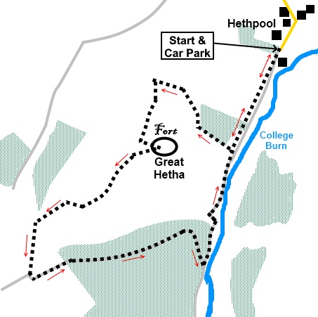
To view route as a dynamic Ordnance Survey map click here. Introduction: This is an easy, short, circular walk which takes you to the summit of Great Hetha at 1125ft (343 metres). The main reason for making this ascent was to see the remains of an Iron Age hill fort, scheduled as an Ancient Monument. Many of these are marked on OS maps but when you get there, there is nothing much discernable, at least to the untrained. This fort is different in that there are the clear remains of the perimeter wall in the form of a large circle of stones and I think I could make out the remnants of a defensive ditch. The other reason for doing the walk is for the lovely views and the sense of solitude. On Great Hetha, I saw not another person and there was not a sound apart from birdsong. Views extended to The Cheviot and across the valley to Yeavering Bell, both of which are covered on other walks. Great Hetha sits above the picturesque College Valley. Access to the valley is limited and to drive beyond the car parking spot, you need to advance purchase a permit. The main reason for doing this would be to climb the Cheviot and once purchased, you would then be at the mercy of the weather. For this reason, my walk route up the Cheviot starts at Langleeford. The College Valley is well known for its wild goats, supposedly descending from some released by monks on Holy Island. I did not see any on this occasion, though did on my Yeavering Bell walk. Red squirrels, adders and roe dear abound although I did not see any of them either! Great Hetha is Access Land and so there are a number of faint paths where people and indeed sheep have made their own way. Essentially, as long as you keep going up, it does not matter a great deal which way you go as you will get to the summit. I was attempting to follow a permissive path marked on the OS map but as you can see from the dynamic OS map, the clearer path I found on the ground did not match the location exactly. However I think I was correct as I passed the Hillfort Trail waymarker. The walk starts from the free car park at the tiny hamlet of Hethpool, the limit of the valley without the permit. To get there, turn south off the B6351, northwest of Wooler, at Westnewton, between Kirknewton and Kilham. Hethpool is signposted. The car park is on the left after about 1¾ miles. Start: From the car park (NT 894281), follow the valley road, beyond the information board.
After a third of a mile, turn right to follow the direction of a fingerpost “Permissive Path Great Hetha ¾ mile” (NT 891274). The path runs up the left hand edge of a plantation. At the end of the plantation, the path runs to the left of a dry stone wall. Follow the wall until you reach a gate with a ladder stile alongside (NT 885279). Do not cross the stile but turn left, to take the faint path immediately opposite, climbing Great Hetha.
The route starts to gently circle the summit anti-clockwise. You should pass the post with the Hilltop Fort Trail sign.
Just after the sign, there is what could be described as a slight grassy “bowl” in the hillside (NT 884275). At the far side of it, strike left, up the edge of the “bowl”, to the summit cairn. You should pass another waymark post and cross the remains of the hill fort wall to reach the summit.
From the summit (NT 886274), the route continues along the ridge in a SW direction, after a hundred yards or so in a northerly direction. The path was obvious on the ground. As you cross the remains of the wall again, you might make out what I think are the remains of a ditch.
To the right of the path at NT 880270 are a few rocks where you can sit for a picnic. The path from the ridge meets another at a ‘T’ junction. Turn right. The path drops down past a small copse of trees to a stile with a fingerpost (NT 877269). Cross the stile and turn left along a tarmac lane, to the white painted Trowupburn Farm.
At the farm, the route goes through a gate, then straight ahead and left after the furthest building. There are footpath arrows on the gate posts. After the second gate, turn left, to follow the stream.
After fifty yards or so, the track crosses the stream and rises to a gate, leading to the forest track. You may notice half way down the side of the plantation a yellow footpath arrow, suggesting the footpath goes through the trees. Well it might but as the forest track runs parallel, I opted to follow this. Looking into the trees further on, it looked like an obstacle course of fallen trees and branches, so I felt the forest track was the safest option.
Follow this track to the Colledge Valley road (NT 889265) and turn left to follow this back to the car park.
If you need to buy any hiking equipment/clothing before your trip see the Hiking Store All information on this site is given in good faith and no liability is accepted in respect of any damage, loss or injury which might result from acting on it.
|
| |||||||||||||||||

.jpg)
.jpg)
.jpg)
%20Great%20Hetha%20from%20start%20point.jpg)
%20View%20along%20College%20Valley.jpg)
%20View%20back%20along%20college%20valley.jpg)
%20Looking%20down%20to%20Elsdonburn%20Farm.jpg)
%20Hillfort%20trail%20waymarker.jpg)
%20Summit%20Cairn%20of%20Great%20Hetha%20with%20Yeavering%20Bell%20etc.jpg)
%20Summit%20cairn%20of%20Great%20Hetha%20with%20view%20to%20The%20Cheviot.jpg)
%20Remains%20of%20the%20fort's%20perimeter%20wall.jpg)
%20Remains%20of%20a%20defensive%20ditch.jpg)
%20Path%20along%20the%20ridge.jpg)
%20Approaching%20Trowupburn%20Farm.jpg)
%20Great%20Hetha%20and%20ridge.jpg)
%20Forest%20track%20on%20return%20journey%20with%20yellow%20broom.jpg)
%20Wild%20flowers%20in%20college%20valley.jpg)