
|
|
|
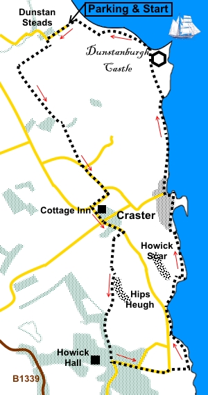
Introduction: This is a
really varied walk, packed with interest. It takes in the village of Craster
but so much more and is a history and geological expedition to boot, not to
mention the potential for bird watching. The walk begins with a country stroll which, although a casual affair, introduces you to rocky outcrops of the Great Whin Sill at Howick Scar and Hips Heugh. These are part of a layer of igneous, dolerite rock which stretches across Northumberland and County Durham. Major projections have formed the base for Dunstanburgh, Bamburgh and Lindesfarne Castles but it is probably best known, at least amongst walkers, for providing the ledge over which flows High Force, in Teesdale. You will see some dramatic curves in the strata of this rock towards the end of the walk at Greymare Rock. One bonus of the cross country section is the delightful garden of the Cottage Inn at Dunstan, should you be in need of refreshment! The walk also passes close to Howick Hall Gardens. After joining the coast at the delightfully named Rumbling Kern, the route progresses to Craster, where it passes through the outside seating area of the Jolly Fisherman pub. As you exit the pub area, you may catch smell of the Craster Kippers being smoked in the premises of L. Robson and Sons who have smoked for about a hundred years.
To
view route as a dynamic Craster Harbour is now a quiet place but was once a bustling port from where stone was shipped from a local quarry, until it closed in 1939. The huge and somewhat ugly concrete structure at the mouth of the harbour accommodated machinery used to lift stone into the boats, for onward delivery. It was also an important fishing base, landing herring, white fish, crab and lobster. Salt herring was also exported from here. Only a small amount of fishing remains. Onward from Craster and you approach Dunstanburgh Castle, which is a dominant feature for much of the walk. Earl Thomas of Lancaster began building in 1313. It subsequently passed to John O’Gaunt before being besieged during the Wars of the Roses (1455 – 1485). It then fell into disrepair. It is now in the care of English Heritage. The promontory on which the castle sits has dramatic cliffs, home to kittywakes and various other birds Finally, just before leaving the coast path, there is Greymare Rock, described above. The walk starts at Dunstan Steads, a tiny hamlet just outside Embleton. To get there, head for Embleton, which is on the B1339 between Alnmouth and Beadnell. On the south side of the village, follow the brown tourist sign bearing the castle, along the road signposted for Craster and Howick. In a quarter of a mile, turn left along a “No Through Road” signposted to Dunstan Steads. When the tarmac ends, you have arrived and there is parking in a large, rough lay-by. Note this car park is used to access the large sandy beach of Embleton Bay, so is likely to be busy at peak times. There is room for about twenty cars. Start: From the car park (NU 244223), walk back along the road towards Embleton. You pass a footpath/cycleway on the left signposted for Craster. You can go this way but I chose an alternative path, to avoid having to mix it with cyclists. To follow my route, ignore this path and continue along the road to the sharp right hand bend. As the road bends sharply right, turn left on to a broad stony track indicated by a public footpath fingerpost (NU 241222). Follow the track to the end of the first field, then turn right, keeping to the right hand side of the hedge. At the end of the field, cross a wooden bridge and follow the path through the trees. At a junction of paths (NU 237218), with a stile on the right, stay on the main path through the trees, curving left. As you approach a caravan site, the path forks indicated by a post with yellow arrows. Fork left. Cross a plank bridge and a stile, then turn right to follow the right hand boundary of the field. As you approach a small wood, go through a walkers’ gate on the right and then bear left to follow a faint path, along a broad green uncultivated stretch, between two cultivated fields. At the road, turn left (NU 246204). At the road junction, turn right following the road sign for “Dunstan ¼ mile”. Follow the road past the Cottage Inn and at the next road junction, turn left following the road sign for “Alnwick 6 miles” (NU 247197). Go straight across the cross roads and continue along the road, keeping an eye out for a farm drive on the right and follow the fingerpost for “Public Footpath to Howick Gates 1¼ miles” (NU 252194). At the end of the tarmac, turn left to follow a rough lane with hedges at each side. The lane opens into a field, where you follow the left hand boundary, until you reach a kissing gate. Through this, bear right to follow the fingerpost for “Howick Hall”. Along here in the near distance you see Howick Scar and pass close to Hips Heugh, on top of which you might just make out the trig. point at the far end.
Look out for a kissing gate with a finger post, in the wall on the right plus a ladder stile. Once through the gate or over the stile, follow the fingerpost for “Howick Hall”. At the end of the field, go through a series of gates, then follow the edge of the wood. The path is clear on the ground. Follow it as it climbs at the end of the first field. You reach the access to Howick Hall turn left and at the road, turn left again (NU 250175). Stay on the road, ignoring the turn for Howick and as it bends left by Seahouses Farm, branch off (effectively straight on) following the public footpath fingerpost towards the sea. Join the coast path at Rumbling Kern, turn left. Note the superbly positioned 19th century cottage, built by Earl Grey of Howick Hall as, in effect, a beach hut for his family.
It is now a simple matter of following the coast, through Craster and on to Dunstanburg Castle, which dominates the view as you progress.
As you approach the castle, go through a gate then bear left to go clockwise round the mound on which the castle sits.
Just after this, look out for Greymare Rock with its dramatic strata.
Follow the coast path and as you are passing the golf course and the start of a wide sweeping sandy bay (Embleton Bay), you will see the car park which you turn left to reach (NU 245224).
If you need to buy any hiking equipment/clothing before your trip see the Hiking Store All information on this site is given in good faith and no liability is accepted in respect of any damage, loss or injury which might result from acting on it.
| | |||||||||||||||||

.jpg)
.jpg)
.jpg)
%20Howick%20Scar.jpg)
%20Hips%20Heugh.jpg)
%20Coastline%20as%20coast%20path%20is%20joined.jpg)
%20Sea%20view%20to%20die%20for.jpg)
%20View%20to%20Cullernose%20Point.jpg)
%20Approachng%20Craster%20Harbour.jpg)
%20L%20Robson%20&%20Sons%20smokehouse.jpg)
%20Craster%20Harbour.jpg)
%20Dunstanburgh%20Castle.jpg)
%20Gatehouse%20at%20Dunstanburgh%20Castle.jpg)
%20Looking%20Back%20at%20Dunstanburgh%20Castle.jpg)
%20Wavelike%20strata%20at%20Greymare%20Rock.jpg)
%20Wide%20sandy%20Embleton%20Bay.jpg)