
|
|
|
To view route as a dynamic Ordnance Survey map click here. Introduction: This North Yorkshire walk is a pleasant countryside ramble starting from the lovely, picturesque hamlet of Shaw Mills. I call it the Shaw Mills Round simply because that is where it starts and there is no particular ‘to’ destination. Along the way there are some nice views although when I did the walk, a general grey and misty day prevented meaningful long distance photos but I was blessed with some nice Autumn colour. There are also some lovely properties, some surprising rock outcrops, not being far from Brimham Rocks oh, and a face! Shaw Mills has a long history and appears to get its name because a Robert Shaw started a corn mill there in the 16th Century at High Mill. In the 19th Century a John and George Metcalf started spinning flax at Low Mill. Both had closed by 1861. They were rejuvenated about 1890 to spin silk but closed soon after the First World War. Both were powered by the beck. In the Second World War, they sprang to life again as tanneries making leather for such as army boots and also blackout fabric. The mill buildings have now been converted to residential use. The walk touches the outskirts of Bishop Thornton and whilst it is no doubt a pleasant enough place to live, most of it is relatively modern housing and it does not have the historic ‘feel’ of Shaw Mills. The walk starts from the top of the cul-de-sac Town Street in Shaw Mills where there is a handy bench for boot changing. The easiest way to get there will depend on the direction of approach but the easiest way for me was to turn off the A61 Harrogate to Ripon road at Ripley on to the B6165 for two miles. Turn right, signposted for Shaw Mills and after crossing the bridge turn left into Town Street. There is a short section of the road at the end by a bench with space to park two or three cars. Please park responsibly Start: From the junction of Town Street and Grange Close in Shaw Mills, keep straight ahead on what remains of Town Street. You will quickly pass a fingerpost indicating it is a public bridleway. You now follow this for about half a mile.
The lane
eventually becomes a rough stony track You reach a point where the main track turns sharply right by a new-ish stone house and another track goes left (SE 252631). Just by the start of the lesser track is a gate on the right. Go through this gate. It was marked with yellow tape when I did the route.
At the
top of the field, go through a gate then follow the left hand boundary to
the corner to cross a dilapidated/collapsed stile. Cross a
stile marked with a post with a yellow top into a field then follow the left
hand boundary to another stile. There is a white arrow on the fence
indicating direction. This will lead you to a small stone bridge (SE 255634). Cross and follow the
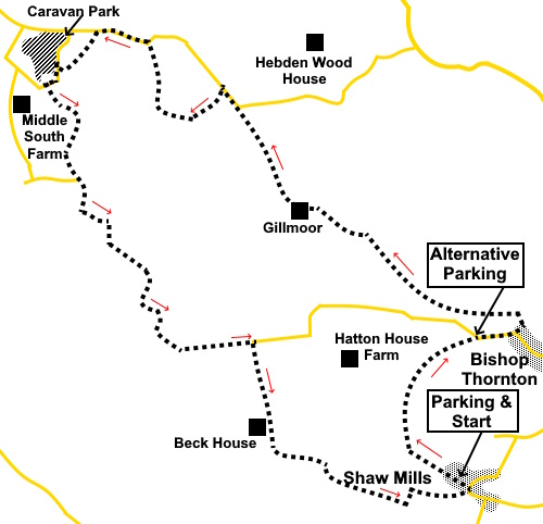
well trodden path to the road. (Note there is a large rough area here which
you could use for parking if Shaw Mills were to be congested (see sketch
map. The circular nature of the walk will return you here). Turn
right along the road for less than a quarter of a mile and on the outskirts
of Bishop Thornton, just by the speed limit sign, turn left to follow a
public footpath fingerpost. Follow the left
hand boundary and cross a stile. Continue through a walkers’ gate and turn
immediately left. Again, follow the
left hand boundary to another walkers’ gate. Beyond this, the path goes
straight across the middle of the field. It was planted with crops but the
line of the path through them was clear. Go through another
gate at the far side of the field and straight across the next field too. You reach a stile
with a yellow arrow pointing left but ignore this and continue straight
ahead, now following the right hand boundary. Continuing following the right hand boundary
for several fields, until you reach the next farm (Gillmoor), Sadly on the
way the path was totally blocked at SE 248641 by
a huge (as in enormous!) pile of
manure. I have reported this to North Yorkshire CC so hopefully it will be
removed but if not, walk clockwise round it to rejoin the field boundary and
go left to continue on the path. At the
farm, in the right hand corner of the field, is a stile. Cross and walk
anti-clockwise round the first building. Keep straight ahead to reach a
broad drive and turn right to follow it. On
reaching the road, turn left to follow it for about two hundred yards.( If
you are navigating by map, you will note there is a footpath off left as you
join the road which might tempt you, as it would rejoin the route. However
unless you enjoy wading through slurry, I would avoid and follow my
direction). Along
the road, reach the sign for High Gillmoor Farm and turn left along its
drive (SE 240651). There is an old style metal fingerpost too. Follow
the drive to the farm and as it curves right to the next one (Low Farm). Go
straight through the farmyard, ignoring a track off to the left as you reach
it. Follow the track into a field bear right. There is an unusual rock marking the start of a short crag. The crag will lead you to a gate and beyond is a short track to the road. Turn left along the road. Note the face in the wall!
After about four hundred yards, cross a stile on the left (SE 231655). This is just before the woodland ahead and the sign for Warren Wood. Follow the edge of the woods.
You will get to a gated entrance on the right. Go through here for a few yards, then turn left (i.e. do not go into the caravan park).
As you walk along the lane, note the impressive rocky outcrop on the right behind a bungalow. Just after this, turn left along a broad track, passing a derelict farm.
Beyond the farm, keep to the right hand boundary and then through a gate, bear left at about 45°. The route was fairly clear on the ground.
At the
far side of the field, ignore the gates and turn right to follow the left
boundary. About
half way down the field turn right, heading downhill, for the diagonally
opposite corner. Here is
a stream which you need to cross, turning left briefly to then turn left
through some old gateposts and right to follow the stream. Go
through a gate and turn left for a few yards along the lane. Turn right to follow a bridleway fingerpost ( SE 230 645). To do this you have to go through some high gates. Judging from the relatively high position of the green button on the right, the idea is that horse riders can press it when it presumably opens automatically, to save them dismounting. However pressing the button did nothing and at first try, I thought the gate was locked. However, I could hear a clicking as I pressed the button and I discovered that the gate could then be pushed open with a (very) firm shove! The auto-mechanism must be faulty.
You now
follow a long, attractive drive to Park House Farm. When you get there, the
route is left at the house and almost immediately right to go clockwise
round the farm on a fenced grassy track. This
leads to a gate. Through this and turn right to follow the edge of the wood
to Woodfield Farm. Follow the track along its right hand side. At the
end of the stone wall, go through a gate and bear left. You meet
the tarmac drive to Woodfield Farm. Turn right along it. It becomes a lane.
Keep a look out on the right for a broad track to Beck House indicated by a
public bridleway fingerpost for
the “Nidderdale Way” (SE 242634). Turn right along it. (I think this may
be mistakenly called Black House on the OS map). Just
before the gateway and cattle grid, turn left through a walkers’ gate,
then right to follow the right hand boundary. About
three quarters of the way down the field, go through a walkers’ gate on
the right, by a sign indicating the “Nidderdale Way”. Cross a footbridge and turn left by a three-way fingerpost following “Shaw Mills”.
Follow
the left hand boundary around the wood and through another walkers’ gate,
continuing to follow the left hand boundary until you reach a gate into the
woods. Here turn right, climbing the hill to the far left corner. Through
a gate, follow the right hand boundary until you reach Cowgate Farm. Here
the route turns left Follow
this track until you reach the road at Shaw Mills and turn left to cross the
bridge then left again into Town Street to return to your vehicle. If you need to buy any hiking equipment/clothing before your trip see the Hiking Store All information on this site is given in good faith and no liability is accepted in respect of any damage, loss or injury which might result from acting on it.
| | |||||||||||||||||





%20Thornton%20Beck%20near%20start%20of%20walk.jpg)
%20Looking%20back%20towards%20Shaw%20Mills.jpg)
%20Autumn%20Colours.jpg)
%20Rocky%20outcrop%20at%20the%20end%20of%20a%20low%20crag.jpg)
%20Face%20in%20the%20wall.jpg)
%20Rocks%20in%20Warren%20Woods.jpg)
%20New%20fence%20and%20autumn%20colours.jpg)
%20Autumnal%20gateway.jpg)
%20Lane%20from%20the%20caravan%20site.jpg)
%20The%20rock%20behind%20the%20bungalow.jpg)
%20Limited%20view.jpg)
%20Drive%20to%20Parkhouse%20Farm.jpg)
%20More%20autumn%20colours.jpg)