
|
|
|
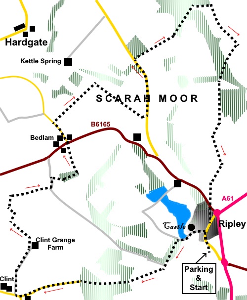
To view route as a dynamic Ordnance Survey map click here. Introduction: This walk has a very slight overlap, at the beginning, with my Ripley Circular route but then heads in a more northerly direction. It is a shorter, easy walk, which ambles through pleasant countryside, though there are no real outstanding features of note apart from Ripley Castle. Scarah Moor is not ‘moorland’ as such, simply an area so named on the map. Ripley itself is a smart,
picturesque village dominated by Ripley Castle which is open to the public.
The village and castle are still owned by the Ingleby family, after 700
years or so. In the centre is a cobbled square and cross, with stocks if you
misbehave! There are a lot of listed buildings in the village and of course
the castle. Unfortunately, the castle was
swathed in scaffolding on this day, so I have used the photo from my other
walk in the interests of completeness. Those of you who can relate the
date of this walk to its recent weather will remember that we had a
considerable amount of rain in the two weeks or so previously so field were
very wet. Having said that, quite a lot of this walk is on tarmac or well
surfaced tracks which eased the pain of the squelchy bits. However for these
bits, I was glad of my gaiters! There is a half mile section of
road walking, along which traffic, though relatively light, does travel at a
pace. However there is a wide verge so it is safe enough. Picnic spots were a little in
short supply, especially given the wet state of the ground
but there were a few stones at the side of a track, where a quick
perch was possible. The site is pointed out below. The walk starts from a free car park at Ripley, where there are public toilets. To get there, turn west of the A61 at a roundabout, between Harrogate and Ripon (signposted). Start: Turn left out of the car park and in the centre of Ripley (SE 284605), where the market cross is situated, turn left to follow the Nidderdale Way. Pass the church and entrance to the castle.
Follow the tarmac surface. Ignore a right turn for Bedlam and continue following the Nidderdale Way until you reach a road junction at Clint. You will pass a fingerpost for “Hollybank Lane, Clint Bank, Hampsthwaite and Burnt Yates”. Pass and ignore a bridleway off to the left indicated on a fingerpost as “The Horseshoe”.
At the Clint road junction (SE 262598), turn immediately right over a cattle grid, to Clint Grange Farm. You follow a fingerpost pointing to “Burnt Yates” but this is at the opposite side of the road to the turn.
At the farm, the footpath turns left, leaving the track. It is marked with a yellow arrow. Head for the fence about fifty yards left of the stone barn and cross the stile. Cross the field and turn left along the broad track. Immediately after passing under power lines, turn right and follow the field edge down to the trees. Turn left and follow the edge of the trees to circle them in a clockwise direction. Cross a stile and turn right to follow the fence on the left. Turn left crossing a footbridge over a stream then bear right towards the corner of the farm enclosure, where you go through the walkers’ gate (SE 261610). .At the end of the fenced section of path, ignore a footpath route off to the left and follow the drive. Immediately after the farm, the drive forks. Keep left. After no more than a hundred and fifty yards, turn right off the drive, crossing a small footbridge and through a metal gate (SE 266612).Head straight across the field to the wood and go through the gate to follow the path through the trees. At the far edge of the wood, exit through a gate and turn left, following the right hand boundary. Exit on to the road via the drive to a house. Go straight over the road and along Law Lane opposite.
After the farm enclosure on the right, continue for two field lengths on the right, along the lane then turn right down a walled/fenced track, following a public footpath fingerpost (which was buried in the hedge!) (SE 266618). Follow the left hand field boundaries down to the stream and cross via a footbridge. Once over the bridge, bear right to pass up the right hand side of the buildings, following the right hand boundary of the field. Join a broad track and turn right along it.
After a quarter of a mile, you will see piles of rocks on the right where you might fin one to fit your bottom, should you want a lunch stop! A sit mat helps (SE 274620)! Continue along the track until you reach the road and turn left. The left hand verge is quite wide and should keep you out of harms way from the fast traffic. After just under half a mile, turn right following a public bridleway fingerpost for “South Stainley” (SE 276626). Cross the river and turn immediately right, following the woods on the left. Go through a gateway (not the one to the farm!) then turn right to follow the Nidderdale Way (SE 285632). The route is clear. Continue until you reach a broad track and turn right to follow the Nidderdale Way sign. At the next junction, keep left.
On reaching the road (B6165) cross straight over and follow the path through the village back to the car park. If you need to buy any hiking equipment/clothing before your trip see the Hiking Store All information on this site is given in good faith and no liability is accepted in respect of any damage, loss or injury which might result from acting on it.
| | |||||||||||||||||

.jpg)
.jpg)
.jpg)
%20Market%20cross%20and%20village%20pub%20in%20Ripley.jpg)
%20Waterfall%20outflow%20from%20lake%20at%20Ripley%20Castle.jpg)
%20Ripley%20Castle.jpg)
%20Open%20countryside%20From%20Hollybank%20Lane.jpg)
%20Another%20view%20from%20Hollybank%20Lane.jpg)
%20View%20near%20Clint%20Grange%20Farm.jpg)
%20Snowdrops%20at%20Beadlam.jpg)
%20View%20after%20leaving%20Beadlam.jpg)
%20Justt%20a%20shot%20I%20liked.jpg)
%20Cottages%20on%20Ripley%20Main%20Street.jpg)