|
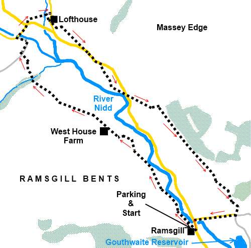
Ramsgill
To Lofthouse
|
Starting
point and OS Grid reference:

Ramsgill
– roadside parking at village green (SE 119710)
|
Ordnance
Survey Map
OS
Explorer Map 298 - Nidderdale.
Buy this map from
List
of OS Maps
Note: If you use OS Maps on-line, you can download this route via this link.
| |
Distance: 5 miles
| |
Traffic light rating:

(For explanation see My
Walks page)
| |


For advice on .gpx files see
My
Walks page
|

Click
the PDF logo above to give a printable version of this walk without the
photos.
|
To
view route as a dynamic Ordnance Survey map click here.
Introduction:
Nidderdale missed out on a Yorkshire
Dales designation when the National Park was founded in 1954, which was a
pity as it is certainly scenic enough to justify inclusion. It has gained
prestige however through being designated as an Area of Outstanding National
Beauty in 1994.
 Not surprisingly, the River Nidd flows through
it and this walk from Ramsgill explores a short pretty middle section of it.
The walk is an easy low level 5 mile “stroll” following the Nidderdale
Way, ideal for the shorter winter days or when conditions higher are
unappealing. It could be linked with my Lofthouse to Scar House Reservoir
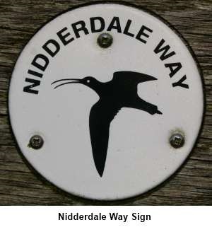
walk if you wanted a longer walk of about 15 miles. The Nidderdale Way sign
with its Curlew will become a familiar sight.
Not surprisingly, the River Nidd flows through
it and this walk from Ramsgill explores a short pretty middle section of it.
The walk is an easy low level 5 mile “stroll” following the Nidderdale
Way, ideal for the shorter winter days or when conditions higher are
unappealing. It could be linked with my Lofthouse to Scar House Reservoir
walk if you wanted a longer walk of about 15 miles. The Nidderdale Way sign
with its Curlew will become a familiar sight.
To get to Ramsgill, heading west through
Pateley Bridge on the B6265, turn right after crossing the river bridge.
Ramsgill is signposted. The road follows the lengthy Gouthwaite
reservoir and Ramsgill is reached shortly after its end. Park on the main
road by the village green, opposite the Yorke Arms where there are
convenient benches for booting up.
Refreshments are a possibility at the Crown
Hotel in Lofthouse but check the times (and days!) of opening.
%20Village%20green%20and%20Yorke%20Arms%20Ramsgill.jpg)
Start:
Facing the Yorke Arms (SE 119710), turn left and walk along the road. After
only 50 yards or so, after crossing the bridge, take the track on the left
then fork right to follow the fingerpost for the Nidderdale Way.
Stay on this main track and when it turns
left to a farmhouse, keep straight ahead, following the right hand field
boundary.
%20Autumn%20colours%20in%20Nidderdale.jpg)
%20View%20looking%20up%20Nidderdale.jpg)
Stay on the track for some distance until
after going through a gate, the field footpath joins a broad track. Turn
left to follow this to West House Farm (SE 108723). The path passes the farm
on a segregated path with a narrow stile at each end. In the field beyond,
the route is marked with posts.
%20Upper%20Nidderdale.jpg)
Eventually, the path drops down to join a
broad track by a barn below High Blayshaw. Turn right. There is a convenient
long length of concrete here where sandwiches can be enjoyed.
As the track crosses the stream, it becomes a
walled lane.
At A ‘T’ junction of tracks by some
cottages (SE 098731), turn right and at the bottom of the cobbled section,
turn left following the direction of the public bridleway sign for Stean.
Stay on what has now become a metalled lane,
passing Studfold Caravan Park. 50 yards or so beyond the caravan park, turn
right across the bridge (SE 097733). At the bridge, you could go straight on
for about ¼ mile to visit How Stean Gorge. Return to this point if you do.
At the road junction, turn right following
the direction of the road sign “Lofthouse ¼ mile” but after only about
50 yards, as the road bends right, go straight ahead through a kissing gate
to follow the footpath across the field to Lofthouse, so avoiding the road
(SE 099735).
Keep to the left of the fire station and
cross the narrow packhorse bridge
over the infant River Nidd and follow the footpath coming out in the centre
of Lofthouse by the war memorial. Turn right.
%20River%20Nidd.jpg)
%20War%20Memorial%20at%20Lofthouse.jpg)
At the memorial Hall on the left, take the
Nidderdale Way to its right (the fingerpost says “Nidd Heads ¼ mile”.
As you enter the field to the right of the memorial Hall, follow its left
hand boundary to the slit stile in the wall and through this, turn
immediately right.
The footpath comes out on the road down some
stone steps (SE 105732). Turn left and walk along the road for slightly less
than ¼ mile before turning right as the road bends left following a finger
post for “Bouthwaite”.
The footpath joins the road again at the
drive entrance to West House Farm. Go straight over the road following the
footpath still signposted “Bouthwaite”. The path climbs the hill towards
the trees to a gate at the corner of two walls. Go through the gate and
follow the left hand side of the wall along by the trees. Gouthwaite
Reservoir soon comes into view. It can be muddy along this section.
%20Gouthwaite%20reservoir.jpg)
Join a broad track at Longside House
(SE117721) and turn right.
Just after passing a farm, the track bend
right but go straight ahead through the gate and follow the contour level
along. The track divides, the left hand branch going uphill but continue to
follow the contour of the hill, straight ahead.
A few yards further on, the track divides
again although the left hand branch (the one you want) is not particularly
conspicuous. Pass to the left of the house.
As you get to more trees, the path descends
towards Bouthwaite. Ignore the large ladder stile on the right and continue
to follow the direction of the path arrows.
Pass between the farm buildings, to the back
of Bouthwaite Grange with its mullioned windows. At a crossroad of tracks,
where the fingerpost indicates the Nidderdale Way goes straight on, turn
right here to follow the tarmac lane back to Ramsgill. At the junction, turn
left back into Ramsgill.
If you need to buy any
hiking equipment/clothing before your trip see the Hiking
Store
All information on this
site is given in good faith and no liability is accepted in respect of any
damage, loss or injury which might result from acting on it.
|


.jpg)
.jpg)
.jpg)