|
Preston,
Redmire and Grinton Moors
|
Starting
point and OS Grid reference:

Preston-under-Scar
(SE 072911) – on street parking
|
Ordnance
Survey Map
OL
30 Yorkshire Dales – Northern and Central.
Buy this map from
List
of OS Maps
Note: If you use OS Maps on-line, you can download this route via this
link.
| |
Distance: 11.3
miles
| |
Traffic light rating:


(For explanation see My
Walks page)
| |


For advice on .gpx files see
My
Walks page
|

Click
the PDF logo above to give a printable version of this walk without the
photos.
|
To
view route as a dynamic Ordnance Survey map click here.
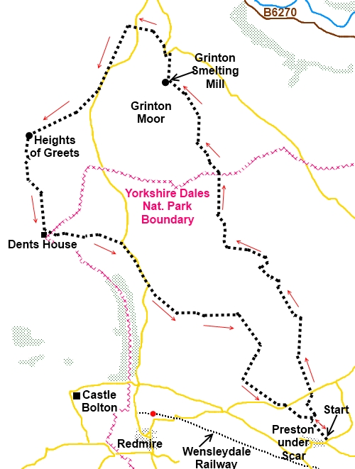
Introduction: This walk starts just outside the north east
corner of the Yorkshire Dales but is partly within its boundary. It is
predominantly a moorland walk but one which provides very good views of
Wensleydale and Swaledale. It also takes you through an industrial history
of lead mining. It is mostly very easy but there is a short section of
moderate steep uphill to Height of Greets hence the amber section.
Start: The walk starts in Preston-under-Scar (SE
072911).To get there, turn north off the A684 at the village of
Wensley between Leyburn and West Witton.
Village%20Spring.jpg) There is only street parking in the village.
There is a small rough lay-by just by the road out of the village to
Richmond next to the village spring and a bench to sit and don your boots
but with only room for one car. You might be lucky! This is where the walk
starts.
There is only street parking in the village.
There is a small rough lay-by just by the road out of the village to
Richmond next to the village spring and a bench to sit and don your boots
but with only room for one car. You might be lucky! This is where the walk
starts.
Walk along the road towards Richmond
(signposted Richmond 10 miles). Just past the 30 mph sign turn left where
there is a green public footpath sign (SE 073912) and over the cattle grid.
After crossing this bear immediately right heading at an angle towards the
trees. Walk along the edge of the trees and at a stile with multiple yellow
footpath arrows, keep straight ahead following the line of the forest.
At the end of the trees, the path opens into
open ground (SE 071915). There is a faint path ahead of you to the disused
quarry which is your route. There are some old concrete supports for railway
tracks as you reach the quarry floor. As you cross the quarry floor, the
wall of rock ahead looks impenetrable but if you look slightly left, there
is a grassy ramp. Proceed up this ducking under the high fence straining
wire at the top. Cross the stile and cross the field to the gate in the wall
ahead.
%20View%20over%20Wensleydale.jpg)
%20Wensleydale.jpg)
Cross the road and go through the gate
immediately opposite (SE 070918). Follow the wall along the field until you
reach a stile with a footpath arrow indicating your route through the trees.
Continue to follow the footpath arrows until after climbing another stile,
you arrive at a cattle grid. Turn left and at the fork in about 100 yards,
turn right (SE 069930).
Stay on the stony track, and at the next
junction of paths, keep right on the main track (SE 064936). At the next
junction where there is a green barrier, fork left, staying on the main
track. Bear left at the next junction where indicated by the public footpath
finger post.
The next turn is not easy to spot (I walked
past it at first) but as the stony track dips down with some grouse butts on
the right, look out for a faint double track on the right obviously used by
vehicles now and again (SE 057941). Follow this across the moor and it leads
to a gate in a stone wall (SE 057951). Go through this and immediately left
through a walkers’ gate. Bear right on a narrow path across the moors.
%20Swaledale%20with%20Reeth.jpg)
As the moor starts to level out and then dip,
you get views of Swaledale and the village of Reeth. The path joins a broad
track. Turn left and follow it down to some stone buildings in a small
valley. These look like barns at first glance and although they do appear
now to be used occasionally for animals, they are actually the remains of
the Grinton Smelt Mill and dates to the 1820s. An information board inside
give you the history and there are the extensive remains of the large flue
on the hillside (SE 049965).
%20Grinton%20Smelt%20Mill.jpg)
%20Remains%20of%20Flue.jpg)
Follow the track down past the old mine
buildings and at the road, turn left and follow the road round over the
bridge. About 150 yards beyond the bridge, take the signposted public
bridleway on the left (SE 049970). The path follows the contour along the
hillside with good views of Reeth and Swaledale. On reaching the road,
continue on the bridleway straight ahead (SE 044973).
%20Swaledale%20and%20Fremington%20Edge.jpg)
On reaching a track which services the grouse
butts, turn left SE (043973). At this junction there is a round stone grouse
butt sunken into the ground. On reaching another broad track, cross straight
over and continue up the hill to the road. Turn right (SE 040967).
Remain on the road until you reach a finger
post on the right hand side indicating a bridle way (SE 039963). Follow this
green path across the open moorland. The path here can be a little faint but
on the skyline is an old spoil heap which from this angle looks a bit like a
volcanic crater. Keep this to your right as you ascend the hill. There are a
few stone cairns marking the way. After passing the “volcano” you see
two small pointed creations on the skyline which are larger stone cairns.
Head for these. As you reach them go through the gate where there is a
summit cairn marking the Height of Greets and turn left.
%20Height%20of%20Greets.jpg)
Follow the broad track down the hill until
you reach a “crossroads” of tracks with a four way fingerpost (SE
031942). Turn left past the small stone building and ugly corrugated steel
barn. It is actually worth pausing here and briefly diverting across the
stream to look at Dent’s Houses, an exceptionally well equipped shooting
lodge which the owners very kindly allow passers-by to use. There is even a
toilet! There is a guestbook you are invited to sign. Please respect this
generous provision and leave the place as you find it.
%20Dents%20Houses.jpg)
%20Old%20Chimney.jpg) Return to and follow the broad track which
exits into a road at a cattle grid (SE 042941). Turn right and walk down the
hill. As the road turns sharp right, keep straight on down the wide stony
track (SE 046935). Just past the chimney at a ruined stone building (just
past a finger post which does not
indicate your route!) turn right and follow what at first glance looks like
a collapsed stone wall but is actually the collapsed flue for the chimney
(SE 059930). Follow it down to a fence and climb the stile over it. Follow
the direction of the footpath arrow. If you hear “shots”, do not panic!
These emanate from a quarry you are about to circle. Follow the path through
a few trees and over the stile by a collapsed wall. Then turn right and take
the path round the side of the quarry. The track takes you down between a
disused quarry on the right and an active one on the left. As you reach a
main track, turn left (SE 060920).
Return to and follow the broad track which
exits into a road at a cattle grid (SE 042941). Turn right and walk down the
hill. As the road turns sharp right, keep straight on down the wide stony
track (SE 046935). Just past the chimney at a ruined stone building (just
past a finger post which does not
indicate your route!) turn right and follow what at first glance looks like
a collapsed stone wall but is actually the collapsed flue for the chimney
(SE 059930). Follow it down to a fence and climb the stile over it. Follow
the direction of the footpath arrow. If you hear “shots”, do not panic!
These emanate from a quarry you are about to circle. Follow the path through
a few trees and over the stile by a collapsed wall. Then turn right and take
the path round the side of the quarry. The track takes you down between a
disused quarry on the right and an active one on the left. As you reach a
main track, turn left (SE 060920).
As the track turns left into the quarry you
carry straight on (SE 065917). There is a red footpath sign although the
arrow points towards you. At the road by the quarry entrance, turn left then
immediately right as indicated by a public footpath fingerpost (SE 067916).
Walk along the top of the old quarry ignoring a stile on the left and at
another stile to the left of a 5 bar gate, cross.
%20Wensleydale.jpg)
You are now walking along the natural
escarpment (on the right) with great views of Wensleydale with a clear sight
of Castle Bolton.
%20Castle%20Bolton%20from%20Preston%20Scar.jpg)
Over the next stile and you are at the trees
you passed at the beginning of the walk (SE 071915). Turn right and follow
the trees back to Preston-under-Scar.
If you need to buy any hiking
equipment/clothing before your trip see the Hiking
Store
All information on this
site is given in good faith and no liability is accepted in respect of any
damage, loss or injury which might result from acting on it.
|


.jpg)
.jpg)
.jpg)