
|
|
|
To view route as a dynamic Ordnance Survey map click here. Introduction:
This walk from Pateley Bridge in Nidderdale to Brimham Rocks offers super
views along and across Nidderdale to Yorkes Folly. There is more information
about this on my Pateley Bridge to Dacre Banks
walk, when you pass the
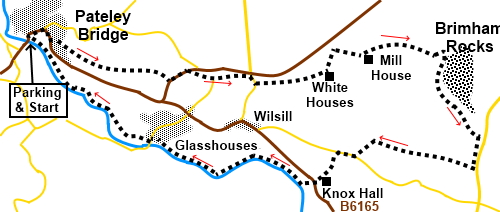
folly. After a little gentle climbing the route visits Brimham Rocks then descends to the River Nidd for a pleasant level stroll back to Pateley Bridge. Pateley Bridge, known locally as simply “Pateley”, is a lovely little market town with lots of small, independent shops, one of which claims to be the oldest sweet shop in England, selling sweets from jars in the traditional way. Choice of pubs too. If you have time, please pay a visit to the Nidderdale Museum, tucked away on King Street to the north of High Street. This really is a fascinating museum of local life with quite a tale to tell about life in the workhouse. It is run by volunteers and very reasonable! Check their website for opening times. Brimham Rocks are a famous, amazing collection of millstone grit rocks sculpted over millennia by the weather into all sorts of weird and wonderful shapes. Many have been allocated various distinctive names such as Eagle Rock and Dancing Bear. A lot depends the angle you see the rocks from and your imagination! You could spend hours wandering round and identifying them all. The site is also a Site of Special Scientific Interest on account of its plant life. It is in the care of the National Trust. Entry is free but if you take your car, there is a hefty car parking charge. There is a kiosk where you can get refreshments and information. There are lots of places where you can picnic. The walk starts from the main car park at Pateley Bridge, which is on the B6265, midway between Grassington and Ripon. My walk to Wath, Gouthwaite Reservoir and the mines and the Pateley Bridge to Dacre Banks walk also starts here. There are public toilets opposite the main car park in Pateley Bridge where the walk starts. It is worth commenting that although the car park in Pateley Bridge is pay and display, it is reasonably priced. Start: Leave the car park and turn right up the steep High Street. Follow it round the corner where it becomes Ripon Road. Look out for Pateley Bridge Methodist Church on the right. Shortly after this, on the left, climb some steps to join Panorama Walk (SE 160656). At one time this was known as Nooking or Knott Lane and was part of a packhorse route from Ripon and is now part of the Nidderdale Way which you will follow for a while.
This steep path takes you past an old well in a stone basin. On its top, difficult to read in the horizontal plane amongst the shrubbery, are the lines: “Ill
Habits gather By unseen degrees, As Brooks run rivers — Rivers run to
Seas. The lines are from Dryden’s translation of Ovid’s Metamorphoses, Book XV. This makes me sound extremely erudite whereas, in fact, I just looked it up! The stone goes on to say; “The
Way to Church. This Stone was restored 1863, 1895. This Stone was restored
1863, 1895. T.B J.F”.
Also
on Panorama Walk is an enclosure “The Rock” or “Pulpit Rock” (SE
164653). This is a splendid viewpoint. Across the valley you can see the
twin towers of Yorke’s Folly. The Rock was fenced and renovated with seats
installed to celebrate Queen Victoria’s Golden Jubilee (1897). There is a
large information board here.
Carry
on past The Rock, passing Pateley Bridge cemetery. As
the track starts to level out and becomes a road, keep straight ahead,
following the Public Bridleway fingerpost for “Blazefield”. As the lane bends right, keep straight ahead on the rough track following the fingerpost for “Nidderdale Way”and “Blazefield ¼ mile”. When the track divides, take the right fork. On reaching the road, turn left (SE 173651) and after two hundred yards, turn right at some stone built cottages (SE 175652) following the fingerpost “Nidderdale Way and Sandy Lane ¼ mile. At the road, turn left. As the road bends sharply left, turn off on the corner on to a broad walled track. On reaching a road, turn right (SE 183651) for a hundred yards and as the road bends right, turn off left following the Public Footpath fingerpost for the Nidderdale Way. As you get to the Llama Trekking Centre, the footpath goes left and then straight on through a gate. At a five way junction of tracks, keep straight ahead following the Nidderdale Way Public Bridleway sign. Arrive at a house and turn right, again following Nidderdale Way and a large painted sign for “Rocks”. On reaching a broad track, turn left. Reach a junction of tracks where there is a large millstone (SE 196654), keep almost straight on but slightly right, leaving the Nidderdale Way and going down a short slope to cross a footbridge. Follow the obvious path to a ladder stile. Cross and bear left to the far left corner of the field. Cross the stile and turn right on a broad track. When you get to the farm buildings, turn sharp right off the track through a metal gate. There is an arrow on the gatepost (SE 205654). At the top of the field, go through another metal gate and turn right on another broad track. Follow the left hand boundary of the field as far as a five bar gate. Go through this and turn right along an obvious path.
After circling round the farm, join a broad track and turn left. At the next junction of tracks, keep left. You arrive at the entrance to the car park of Brimham Rocks. To see the rocks, go through the car park. Otherwise, turn right along the private road to Druid’s Cave farm (SE 208645).
Just before the National Trust boundary sign, take the footpath on the left. This immediately divides. Keep right. There are some nice views along this section. The path drops down to a wide track but just before this, turn right over a stile next to a gate, marked with a blue bridleway arrow.
Follow the bridleway down hill, ignoring any turns off. The bridleway joins a concrete drive. Turn left along it (SE 196643). At the road, turn right. Keep a look out on the left for a Public Bridleway Low Laithe, just after a letterbox. Follow the bridleway to the road and go straight across following the Public Footpath fingerpost. The footpath leaves the field in the bottom right hand corner. Join the river and follow the footpath along its right hand (north) bank.
Keep following the right hand bank of the river to Glasshouses. Here the old mill complex was being redeveloped and turned into houses/apartments. You have to circle anti-clockwise around the mill complex to regain the riverbank and turn right to continue to follow the river back to Pateley Bridge. You pass the old mill dam and weir.
If you need to buy any hiking equipment/clothing before your trip see the Hiking Store All information on this site is given in good faith and no liability is accepted in respect of any damage, loss or injury which might result from acting on it.
| | |||||||||||||||||

.jpg)
.jpg)
.jpg)
%20Looking%20down%20Pateley%20Bridge%20High%20Street.jpg)
%20Well%20on%20Panorama%20Walk.jpg)
%20Looking%20along%20Panorama%20Walk.jpg)
%20View%20from%20The%20Rock.jpg)
%20A%20determined%20tree.jpg)
%20One%20of%20the%20rock%20formations%20at%20Brimham%20Rocks.jpg)
%20View%20descending%20from%20Brimham%20Rocks.jpg)
%20View%20up%20Nidderdale.jpg)
%20Old%20railway%20arch%20near%20Glasshouses.jpg)
%20Old%20mill%20dam%20at%20Glasshouses.jpg)
%20Sluice%20gear.jpg)
%20Weir%20and%20reflections%20near%20Glasshouses.jpg)
%20Reflections%20on%20the%20river%20Nidd.jpg)