|
Masham
to Druids' Temple
|
Starting
point and OS Grid reference:

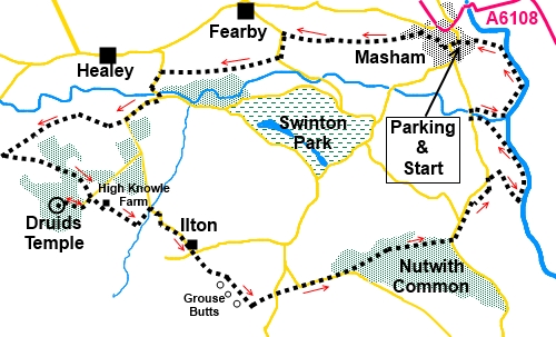
Masham
– Honesty box parking in market square (SE 225807).
|
Ordnance
Survey Map
OS
Explorer 298 – Nidderdale and OS Explorer 302 – Northallerton and Thirsk.
Buy these maps from
List
of OS Maps
Note: If you use OS Maps on-line, you can download this route via this
link.
| |
Distance: 12 miles
| |
Traffic light rating:

(For explanation see My
Walks page)
| |


For advice on .gpx files see
My
Walks page
|

Click
the PDF logo above to give a printable version of this walk without the
photos.
|
To
view route as a dynamic Ordnance Survey map click here.
Introduction:
This walk from Masham follows the
Ripon Rowel walk for parts of its length. This should make these sections
easy to follow, although I did find some did not seem particularly well
marked. The first half of the walk, until I climbed to the Druids’ Temple,
was also obscured by thick mist in the valleys (which lasted longer than
forecast!), so photos are more limited than usual.
The Druids Temple is a folly built around
1820, by William Danby of Swinton Hall to provide employment. It is a pretty
realistic creation and if you did not know otherwise, it could be thousands
of years old. Above it is an impressive pillar of flat stone slabs.
The latter part of the walk follows the
course of the river Ure.
There is some walking on country lanes but
there is very little traffic. I saw only one post van on the lanes during
the entire walk.
It is an easy, fairly level walk, so do not
let the distance put you off, as you can make good time. There are some
muddy sections so I recommend gaiters after wet weather.
There is a café at High Knowle Farm, about
half way round which seems to be open most days (more limited in January –
check website)
The walk starts from the large market square
in Masham which has an “honesty box” scheme of modest request. Public
toilets are nearby. Masham is situated just off the A6108 about half way
between Ripon and Leyburn.
Start:
In the market square (SE 225807) with the market cross behind you and the
flagpole in front, walk ahead to Chapman Lane and turn right to Church
Street. Turn left along Church Street and follow it left round the corner
past the HSBC bank when it becomes Park Street. Turn right on Red Lane (just
before the Co-op shop).
%20Market%20Cross%20at%20Masham.jpg)
Follow Red Lane and fork right at the fire
station. Continue to follow Red Lane until it eventually becomes Westholme
Road. Stay on Westholme Road until it bends right at 90°. Turn left on the
bend along Foxholme Lane (SE 220809), over the narrow bridge and passing
Jamesons Animal Feeds.
Just past the factory, the tarmac ends. Go
straight ahead following the public footpath fingerpost for “Ripon
Rowel” and “Micklebury Lane 1 mile”. Ignore a turn off to the left
almost immediately and stay on the broad track.
As the track turns into a farmyard, go left
along the right hand edge of the field following the yellow footpath arrow.
At the end of the first field, go through two gates and then turn left,
again following the yellow arrow.
You reach a road on a bend with a covered
water reservoir to the right (SE 203809). Turn left and walk along the road
for less than a quarter of a mile. When the road bends left (SE 202806),
turn right along a broad rough track and when it reaches another road, turn
left (SE 187804).
Stay on the road, crossing the River Burn and
at the ‘T’ junction, turn right signposted
“Ilton 1½ miles”.
Remain on the road for a third of a mile and,
on a sharp left hand bend, continue straight ahead on the public bridleway,
passing under some power lines and passing a stone sign for
“Broadmires”.
Just past the farm, go through a gate and
continue straight ahead, following the obvious track.
Go through another gate by the trees and go
straight ahead following the blue bridleway arrow.
Walk alongside the next set
of trees (Hall Wood). The edge of the trees curves away from the track at SE
169795. Stay on the track but before entering the next group of trees, turn
sharp left at a three way fingerpost (SE 167793) to continue to follow the
Ripon Rowell Walk towards Lower Knowle Farm.
Close to the diagonally
opposite corner of the next field, go through a walkers’ gate and follow
the broad track just above the gate, rising left towards the trees. This
track then curves right, along the edge of the trees.
The track turn left through a gateway (SE
175291), indicated by a public footpath sign, then turns right, soon passing
between two ramshackle stone structures and lines up with power lines.
Follow the track to the road and turn right (SE 179788), entering the
Swinton Estate to see the Druids’ Temple. This is accessed by a clearly
delineated grassy path from the car parking area.
%20Entrance%20to%20Druids%20Circle.jpg)
%20Druids%20Circle%20from%20above.jpg)
%20Stone%20stack.jpg)
After seeing the Druids’ Temple (SE
174787), return to the point where you joined the road and turn right to
follow the fingerpost for “Public Footpath, Ripon Rowel, Sole Beck ½
mile”.
%20View%20SEfrom%20near%20Druids%20Temple.jpg)
%20Descending%20to%20Sole%20beck.jpg)
Walk down past High Knowle farm. There is a
café here which seems to be open every day except January, when it is
weekends only. Turn left at the rear of the farm and follow the buildings
round. Opposite the far back corner, turn right over a wooden stile
following the yellow footpath arrow.
The path descends to Sole Beck where you turn
left to follow the broad grassy track by the trees (SE 184785).
%20Mist%20in%20the%20trees%20at%20Sole%20Beck.jpg)
On reaching the road, turn right. You soon
come to Ilton. Stay on the main road through the hamlet. Just after passing
Manor Farm to your left, the road bends sharp left. Leave the road here by
the footpath straight ahead (SE 191781). Cross the rough ground heading for
the far left hand corner where there is a narrow stone slit stile. Cross
this and go straight ahead for about 50 yards where there is another similar
stile on the left. Go through this and bear right. You should be able to see
the next stile in the wall at the top of the field.
%20Distant%20views%20as%20mist%20cleared.jpg)
Once through this stile, the path is obvious.
It bends right after a few yards and runs along the rear of a number of
shooting butts across an area intriguingly called Galloper on the OS map.
%20Grouse%20Butts%20at%20Galloper.jpg)
Just before a stone house, join a stony track
and turn left (SE 199744), through a metal gate. Stay on this track until
you get to a crossroads and go straight ahead on the road.
At the next road junction, turn right
following the road signs for “Grewelthorpe 2¼ miles” and “Kirkby
Malzeard 4 miles”.
Stay on the road for about a third of a mile
and on a slight bend, look out on the left for a double public footpath
fingerpost pointing into the trees (SE 210779). Turn left here and follow
the main track, which curves to the right.
At the road, go virtually straight on (SE
224783), leaving the road on a public bridleway which swings left. This runs
virtually parallel with the road but is a more pleasant walk than the road.
When the bridleway rejoins the road, turn
right along the track to Nutwith Cote Farm (SE 232788). Pass the farm, then,
as the main track bends right, you go straight ahead. Follow the left hand
boundary of the field and go through a metal gate. There is a yellow
footpath arrow to indicate the route. Note the ruin on the hill to the
right. Evidently this is the ruin of a dovecote.
%20Dovecote%20at%20Nutwith%20Cote%20farm.jpg)
Turn left and make your way down to the
river, turning left to follow the riverside path. Initially, it follows the
River Ure but at the junction with the River Burn, swings left to follow
this to the road. Here, cross Lower Burn road bridge then turn immediately
right to follow the opposite bank of the River Burn, rejoining the River Ure
footpath. Along here is a mysterious stone arch (SE 232801) – see photo.
Evidently this is a stone sculpture by Alain Ayres from the 1990s called the
Floating Leaf and marks the spot where there once was a ferry across the
river.
%20River%20Ure.jpg)
%20Floating%20Leaf.jpg)
Follow
the footpath which eventually becomes a tarmac lane eventually forming
Millgate which opens into Masham market square. The steeple of St Mary’s
Church in Masham provides a reference point and will have been in sight for
some time.
If you need to buy any
hiking equipment/clothing before your trip see the Hiking
Store
All information on this
site is given in good faith and no liability is accepted in respect of any
damage, loss or injury which might result from acting on it.
|


.jpg)
.jpg)
.jpg)