|
Howardian
Hills From Terrington
|
Starting
point and OS Grid reference:

Village of Terrington - on
street parking at the village green (SE 669707)
|
Ordnance
Survey Map
OS
Explorer 300 - Howardian
Hills and Malton.
Buy this map from
List
of OS Maps
Note: If you use OS Maps on-line, you can download this route via this
link.
| |
Distance: 10.2
miles
| |
Traffic light rating:

(For explanation see My
Walks page)
| |


For advice on .gpx files see
My
Walks page
|

Click
the PDF logo above to give a printable version of this walk without the
photos.
|
To
view route as a dynamic Ordnance Survey map click here.
Introduction:
The Howardian Hills are an Area of Outstanding Natural Beauty as the name
suggests, near the stately home Castle Howard, between the North York Moors
National Park, the Yorkshire Wolds and the Vale of York. The overall area is
some 79 square miles. This very easy walk starts at the village of
Terrington and includes a low ridge walk with views both sides following the
course of extensive ancient earthworks which can be clearly made out on the
ground.
Some road walking is
involved and in particular, a country road to the rear of Castle Howard can
be quite busy however there are wide verges for much of it.
Terrington is to the west
of Malton with various approach routes so it is best to consult a road atlas
or my Google map of walk starting points as to the best way to get there.
There is only on street
parking in Terrington. There is a small triangular village green with room
to park at the rear, off the High Street and there are benches for boot
changing.
%20Village%20Green%20Terrington.jpg)
%20Terrington%20Church.jpg)
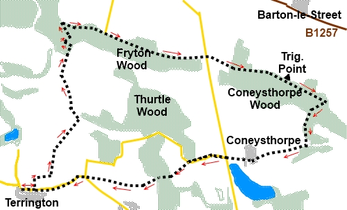
Start:
From the village green (SE 669707) , turn right (east) along the
High Street. Turn left at Church Lane (SE 672707) and just past the church,
when the road bends, go straight ahead and then along the grassy footpath to
the left of the house. A finger post indicates the public footpath.
On reaching the football
field, turn fight following the fingerpost for the Ebor Way. At the edge of
the football field, go slightly right and follow the obvious path along the
edge of the next field. It then turns sharp left (Se 675709), running along
the edge of the next fields.
On reaching a broad track
(SE 6880721), turn left and left again at the next junction. On reaching
Howthorpe Farm, turn right between the farm buildings to follow the
Centenery Way (signposted).
At a threeway fingerpost
indicating Fryton to the right, and Centenery Way, Ebor Way and Hovingham to
the left, do not turn off but carry straight ahead on the broad track.
Take the path indicated by
blue (bridleway) arrows into the trees (SE 678734).
%20Rolling%20countryside%20of%20the%20Howardian%20Hills.jpg)
%20Rolling%20countryside%20of%20the%20Howardian%20Hills.jpg)
At a fourway fingerpost as
you come to the edge of the trees, turn right signed Centenery Way and
Howardian Hills AONB.
At another fourway
fingerpost with Appleton-le-Street 1 mile, Park House ¾ mile and Slingsby
Bank 1½ miles, turn right just signposted as a public bridleway and walk
along the ridge (SE 677739). Note earth works on the right amongst the
trees.
%20View%20North%20towards%20the%20North%20Yorkshire%20Moors.jpg)
After 1¾ miles you reach a
road and the footpath continues straight across it.
%20Trig%20Point%20Hidden%20in%20Hedge.jpg)
Pass the trig. point (SE
718728)which is to the left in the middle of the hedge between the fields
(not on the footpath) and which may be difficult to spot when the hedge is
in leaf. Take the next clear track on the right (SE 727724). As it descends,
there is another track off to the left through the trees but ignore this.
On reaching the road (SE
723715), turn right and walk through the village of Coneysthorpe. At the
road junction with the impressive gateposts belonging to the Castle Howard
Estate and providing one of the best views of the house, go straight ahead.
%20Rear%20of%20Castle%20Howard.JPG)
%20Castle%20Howard%20and%20its%20lake.jpg)
Shortly after a white
painted gate between more impressive gateposts, look out for a finger posted
footpath on the left for Ganthorpe and Terrington (SE 701712).
Go over a small footbridge
then bear diagonally right across the middle of the field towards the trees
at the far side. Once in the trees, go downhill on the broad track and as it
divides, keep to the right.
The path goes through a
couple of gateways with the route clearly marked with yellow footpath arrows
then descends a field to the corner following the right hand fence then turn
left to follow the fence along towards a stand of trees. Go through the
kissing gate following the direction of the yellow arrow.
Walk along the edge of the
trees then straight ahead along the field edge. On reaching the road, go
straight ahead to Terrington.
If you need to buy any
hiking equipment/clothing before your trip see the Hiking
Store
All information on this
site is given in good faith and no liability is accepted in respect of any
damage, loss or injury which might result from acting on it.
|


.jpg)
.jpg)
.jpg)