
|
|
|
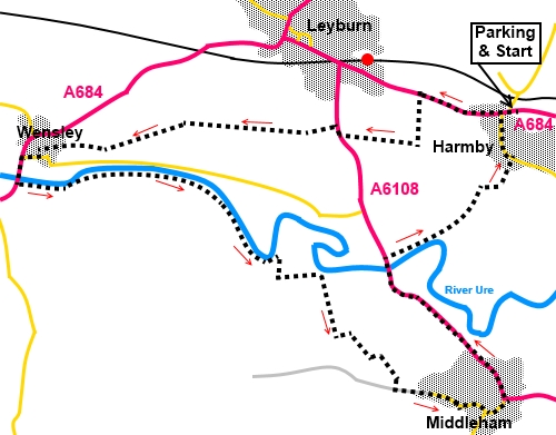
To view route as a dynamic Ordnance Survey map click here. Introduction: This walk from Harmby to Middleham could equally be done from Leyburn. I could have merged it with my walk from Leyburn to Wensley but I wanted to allow time to visit Middleham Castle and have a pub lunch! The walk offers good views of Wensleydale and passes through the village of Wensley where there is a decent pub and a candle makers, where you can watch the process. There is also a pleasant stretch by the river Ure. The jewel in this walk however is Middleham. A picturesque if busy little town, with good pubs, tea rooms, shop and of course the enormous Middleham Castle, which dominates the town. It is also a famous centre for racing stables. A potted history. The castle has the largest keep in the North and was at one time home to Richard III. It has great views from the top. Its construction started in the 12th century. In 1260, it passed into the Neville family by marriage, where it remained until 1471, when the castle and lands were acquired by Richard III. After Richard was defeated by Henry Tudor in 1485, at the Battle of Bosworth and Henry was crowned, the castle passed to the Crown. By 1538, it was already in a poor state. It was subsequently passed between various families but steadily declined, really until it became the responsibility of the Office of Works, in the 1930s. It is now under the care of English Heritage. I would strongly recommend a visit. The walk starts from Harmby on the A684, just east of Leyburn, where there is a small amount of parking in a short “loop road” by the Pheasant Inn (SE129899). The walk could also be started from Leyburn. Indeed, subject to having the time available, this walk could be combined with my Leyburn to Wensley walk, by continuing from Wensley to Middleham and ultimately walking from Harmby to Leyburn, along the road (there is a pavement). This would give a walk of about 11 miles. Start: From Harmby, walk west along the A684 for less than half a mile. Opposite the Tennants centre (auctioneers, saleroom, exhibition centre etc etc), turn left, following a broad tarmac track and a public footpath fingerpost (SE 121900).
When the tarmac ceases, follow the stony track ahead, passing Craken Mill. Just inside the gates at the farm, turn right following the public footpath fingerpost. The stony track turns to tarmac again. Follow this through to the road and turn right (A6108) for a few yards. Just as you get to the bend in the road, turn left following a public footpath fingerpost (SE 115898). The path bears right through the gate and is pretty clear on the ground. Go through a couple of gated stiles and at the end of the field beyond them, the path forks. Keep straight ahead following the yellow arrow, ignoring the path to the right. The path is easy to follow, with a series of stiles and arrows marking the route until you drop down some steps into an old walled lane. The continuation is a little difficult to spot but is opposite, slightly to the right, climbing up some more steps (SE 109898). The route is now easy to follow again, once more guided by stiles, arrows and trodden turf, leading to Leyburn Glebe Nature Reserve, indicated by a sign. Follow the path along the right hand side of the field and round the top side of a wood, via a small footbridge. (SE 100897). Beyond here, follow the obvious track to Wensley, which you can see ahead of you. The path arrives at a tarmac lane in Wensley. Turn left along it. Follow it down to the road and turn right. On reaching the A684, by the church, turn left to cross the river Ure via the road bridge, then, turn immediately left to follow the right hand bank of the river.
Stay on this path, passing two long, narrow strips of woodland on your right, at right angles to the river. After just under half a mile, cross a small stream, just by a shingle island in the river. Turn right here to follow the left hand bank of the stream (SE 111888). When the stream turns right, keep straight ahead, to join a broad track leading to a farmhouse, off to the right (derelict when I did the walk). Turn left along the track. Follow the track until you reach a farm gate (SE 114887). To the right is a walkers’ gate Go through this following a blue bridleway arrow. Head straight up the field. As you reach the brow of the hill, there is a walkers’ gate just ahead. The white of the back of a notice on the fence next to the gate which helps to picks it out. Go through this and a second gate, then follow the left hand boundary wall. When the wall ends, keep straight ahead, through another gate and follow the obvious path. The outskirts of Middleham start to appear.
When the path divides, keep left. At the next gate, there are two sets of arrows (SE 118881). Either route will take you into Middleham but I chose the right hand way, indicated by a blue bridleway arrow, to the diagonally opposite corner of the field, to the left of a small bungalow. Turn left by the bungalow to follow a stony track to a tarmac drive and turn left along it, into the village. You have to push a button to open the electric gates, which close automatically afterwards.
Enjoy the castle/pubs etc, then to continue the walk, from the market cross, turn down the A6108, to cross the river Ure via the ornate castellated bridge. This is quite a busy road but fortunately there is a very wide grass verge for most of the way, apart from a less than a quarter mile section to the bridge.
Once across the bridge, turn immediately right following a public footpath fingerpost (SE 119888). Follow the path by the river, until is starts to curve away to the right. Cross a small ditch via a bridge. Shortly after the bridge, go left through a farm gate following a yellow arrow. As you get to the end of the field, head for the top right hand corner where there is a stone step stile. Cross this and a second stile to join a tarmac drive. Turn right, crossing a cattle grid (SE 126894) At the ‘T’ junction, turn left and left at the road to walk through Harmby to the main A684 and the car parking. If you need to buy any hiking equipment/clothing before your trip see the Hiking Store All information on this site is given in good faith and no liability is accepted in respect of any damage, loss or injury which might result from acting on it.
| | |||||||||||||||||

.jpg)
.jpg)
.jpg)
%20View%20to%20Pen%20Hill.jpg)
%20View%20along%20Wensleydale%20to%20Addleborough.jpg)
%20River%20Ure%20From%20Wensley%20Bridge.jpg)
%20River%20bridge%20at%20Wensley.jpg)
%20Looking%20up%20Wensleydale.jpg)
%20Entering%20Middleham.jpg)
%20Inside%20Middleham%20Castle.jpg)
%20View%20from%20Middleham%20Castle.jpg)
%20View%20to%20Pen%20Hill%20from%20Middleham%20Castle.jpg)
%20Market%20Place%20at%20Middleham.jpg)
%20Middleham%20Bridge%20over%20the%20River%20Ure.jpg)