
|
|
|
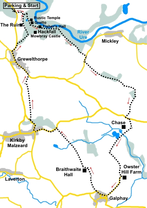
To view route as a dynamic Ordnance Survey map click here. Introduction: This circular walk from Hackfall woods is a pleasant saunter along some of the quiet lanes and bridleways of North Yorkshire encompassing some lovely villages and some of the ornamental landscape and follies of the woods themselves. Hackfall woods were acquired by the Aislabie family in 1731 and between about 1750 and 1767, work was undertaken to transform them into an ornamental landscape with the construction of various “follies” and strategic felling of trees. Hackfall is Grade I listed on the English Heritage “Register of Parks and Gardens of Historic Interest”. You could spend a considerable time meandering around these woods to look at all the “follies” created but that was not the intention of this walk. However, you get a generous taste by seeing.
Just outside Galphay, you pass Braithwaite Hall, an unusual looking house dating from the 16th century (not to be confused with Braithwaite Hall at East Witton). At about the half way point of the walk, Galphay boasts a small and larger village green, both of which have benches, ideal for a picnic stop. It also has the Galphay Inn which does food but check its website for opening hours which vary. Similar facilities exist in Kirkby Malzeard and Grewelthorpe.
The walk starts at the car park for Hackfall. This is situated on the right, just over half a mile north of the village of Grewelthorpe, on the road to Masham. Cross country routes can be quite tortuous so unless you know the area (or have sat. nav.), the easiest way to find it would be to take the A6108 from Ripon to Masham. After crossing the river bridge, take the first left, which leads to the market square. Turn right, avoiding the square itself then follow the Grewelthorpe signs. The parking area will then be on the right 2.3 miles from the market square. Describing the route precisely through the woods is not easy because of multiple tracks and lack of identifiers. I will do my best but if you feel you have gone wrong, head for the River Ure and follow it along to SE 246767, indicated by # below. Please note after rain, this can be a muddy walk so gaiters are recommended. Start: Turn left out of the car park (SE 230775) following the public footpath fingerpost for “Hackfall Wood ½ mile”. After about a hundred yards, at a five bar gate, turn right, before going through it, and through a walkers’ gate up a short bank.
When the path divides at a marker post, turn left for Fountain Pond. At the next junction of paths, turn right along a descending path to the pond (SE 234773). Keep left of the pond.
At the next junction, turn right but do not follow the sign for “Follies and Grewelthorpe” but cross the stream slightly left, after passing The Rustic Temple and The Grotto.
At the next junction, go left to see Fisher’s Hall. Return from Fisher’s Hall and just before the point where you turned left, take the path to the left, along the left hand bank of the stream, marked as the Ripon Rowel Walk.
Arrive at a junction where, to the left, are steps rising back to Fisher’s Hall. Cross the stream immediately opposite the bottom of the steps and follow the path through the woods. You are now following the right hand (southern) bank of the River Ure. Pass a path off to the right signed to Mowbray Castle. Were this a “real” castle, rather than a folly, it might be worth the trip but there is a better, if more distant view of it, towards the end of the walk. # At SE 246767, fork right at a post, leaving the Ripon Rowel Walk (which goes left). At SE 247765, leave the woods via a stile and turn left following the path through a gateway. Follow the left hand field boundary to the road and turn right. After about 150 yards on the road, just before the bend, turn left through a gateway to follow a public bridleway fingerpost. It is also marked with a blue arrow. Stay on the bridleway, ignoring a left turning footpath at a gate. You cross a faint broad track leading down to a stream then meet a broad stony track and turn right, following the left hand boundary of the field. Also, further on, ignore a bridleway off to the right. On meeting the road (SE 262755), turn right and walk along it for half a mile. At the road junction, turn left and almost immediately right along a no through road, next to a white cottage. This tarmac lane arrives at a ‘T’ junction with a rougher track. Turn right along it. Do not confuse with the footpath going through the private garden. The track curves left and becomes Hubber Lane marked on the OS map and indeed, you will pass a fingerpost confirming the name further on. Turn left on a public bridleway at SE 255739, about a third of a mile after the ‘T’ junction. (You could if you wish shorten the walk by about 1½ at this point by continuing along Hubber Lane to Braithwaite Hall and picking up the route again there but this would miss out Galphay). There are good views along here towards the North York Moors. On arrival at Owster Hill Farm, turn right along the tarmac lane to the small triangular green at Galphay. There is a bench here for a potential picnic stop. Turn right along the main street and there is another large village green with more seats.
At the larger green, turn right on the road, following the road sign for Kirkby Malzeard, passing the Galphay Inn pub. On the edge of the village, as the road turns left, go right through the imposing gates, to Braithwaite Hall. The route passes the front of the hall and curves right along the broad track.
At a pair of five bar gates, go through the right hand one and follow the path across the fields. This is obvious on the ground and leads more or less in a straight line to a road. Turn left along it and at the cross roads in Kirkby Malzeard, turn right. Follow the road through Kirkby Malzeard, past the church and round the bend at the bottom of the hill. Just after crossing the bridge, look out for a gap in the wall on the right. Go through this and climb up the banking to the stile which is visible. There was a rotted fingerpost leant against a tree which I suspect was to mark the turn off the road. Hopefully it will be replaced.
Cross the stile at the top of the banking and continue straight ahead in the same direction. The path dog-legs round a farm but otherwise runs fairly straight to meet the road, just outside Grewelthorpe. Turn left through the village with its lovely village pond.
Follow the road to the junction for Masham and turn right here. Continue along this road for about 200 yards. On the right, at SE 230767, turn off the road on to a footpath. There is a prominent sign board here with various names but most noticeably “Hackfall” and “Woodland Trust”. Descend some stone steps and then turn left. When the path fork, go left following the sign for “The Ruin” and “Car Park”. Pass the ruin and note the great views across towards the North York Moors and of Mowbray Castle.
Eventually you descend the three steps you climbed near the start of the walk. Turn left, back to the car park. If you need to buy any hiking equipment/clothing before your trip see the Hiking Store All information on this site is given in good faith and no liability is accepted in respect of any damage, loss or injury which might result from acting on it.
| | |||||||||||||||

.jpg)
.jpg)
.jpg)
%20Ripon%20Rowel%20sign.jpg) The walk then briefly follows the banks of river Ure,
following the Ripon Rowel walk
The walk then briefly follows the banks of river Ure,
following the Ripon Rowel walk %20View%20to%20Masham%20from%20the%20car%20park.jpg)
%20View%20from%20car%20park%20to%20NY%20Moors.jpg)
%20Fountain%20pond.jpg)
%20Rustic%20Temple.jpg)
%20The%20Grotto.jpg)
%20Fisher's%20Hall.jpg)
%20Smaller%20Green%20at%20Galphay.jpg)
%20larger%20Village%20Green%20Galphay.jpg)
%20Braithwaite%20Hall.jpg)
%20St%20Andrews%20Church%20Kirkby%20Malzeard.jpg)
%20Village%20pond%20at%20Grewelthorpe.jpg)
%20Trees%20on%20the%20green%20at%20Grewelthorpe.jpg)
%20Mowbray%20Castle.jpg)
%20The%20Ruin.jpg)