
|
|
|
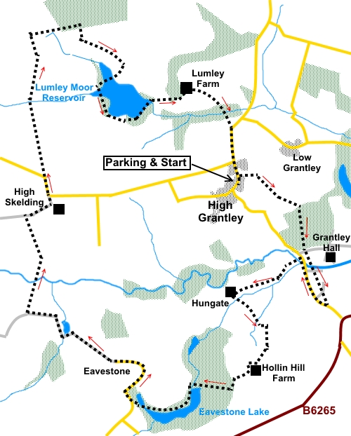
To view route as a dynamic Ordnance Survey map click here. Introduction: This North Yorkshire walk from High Grantley takes you past two significant stretches of water, Eavestone Lake and Lumley Moor Reservoir. It also passes some smaller fishing ponds, too small to count as “Lakes”. Eavestone
Lake is an attractive stretch of water with an old stone arch bridge and was
created by damming the stream, Hungate Dyke. It has some interesting rock
formations which you pass and will be attractive in spring/early summer on
account of the profusion of rhododendrons. Lumley Moor Reservoir is less well known than many other reservoirs but has a pleasant path encircling it. The map shows the footpath going straight across it but messianic abilities are not required to cross as there is a causeway along a raised banking, splitting the reservoir. The reservoir is some 27 acres in extent and is another supply for Yorkshire Water. It was originally built in the late 19th Century to supply Ripon. High Grantley is a picturesque quiet village on the north side of the River Skell. Nearby is Grantley Hall, a Grade II listed building. The gardens have all the features of a grand country house, with extravagant landscaping, water features etc but unfortunately are not open to the public.
The walk starts from High Grantley. Parking is on the road. Please be careful not to block gateways as space is limited. There is a lay-by by the phone box but this is often full. In the interests of consistency, the walk directions start from The Grantley Arms. There are no refreshment facilities en route, once you leave the Grantley Arms. To get to High Grantley, turn north off the B6265 between Ripon and Pateley Bridge, at Risplith.
Start: With your back to the Grantley Arms, turn left along the road. After twenty-five yards or so, turn right following a public footpath fingerpost through a kissing gate (SE 233701). Turn right through a gate marked with a yellow footpath arrow. Keep to the left of the power lines and look out for a small stile in the hedge which is difficult to spot. Cross it and turn right, once more following a yellow arrow. Follow the right hand field boundary and cross another stile at the bottom of the field, to follow the right hand boundary. As you get near the end of the field, bear about 25° left to cross two more stiles. Bear slightly left to the corner of a fence by a house. Head for the far corner of the field and cross two stiles to turn right into the woods (SE 239698). The route through the trees can be a little difficult to see at first but is virtually due south. Yellow “blobs” on the trees mark it. If you are quiet, you may be lucky enough to see some roe deer. Cross a wooden footbridge and cross the drive ahead, then keeping to the wall on the left. You may note from the map that if you were to turn right along the drive you would reach the road and cut off a corner. However this is private property. On reaching the saw-mill, turn left along its track for a few yards then right at the large barn like building (there is a yellow arrow on its corner). Curve anti clockwise round the barn and as you do, look out for the footpath on the right. Cross a couple of stiles then follow the left hand boundary to another. Cross the tarmac drive and the path bears slightly right, following the right hand bank of the stream to the road. Again, it will be tempting to use the drive to short cut to the road. Turn right at the road (SE 241689). Walk along the road and as you get to the lodge house, turn left over an attractive stone bridge following the fingerpost for “Eavestone 1 mile” (SE 239693). When the track bends left, you effectively go straight on – i.e. going right, off the track at the corner. Pass a fairly new stone house named Hungate Rise then a little further at Hungate itself, turn left after the property on the left and through the gate (SE 233689). Walk down and cross the small stone bridge. Climb the bank to a wide track and turn left. There is a yellow arrow on the gatepost. Look out for a path off to the right just before reaching a stone wall. If you get to the wall, you have missed it! Cross a stile by an old barn (SE 234688), and follow the path through the trees, along the left hand boundary to another stile. Over this, keep straight ahead through a gateway. Turn right here following the yellow arrow.
Climb the field heading for the right hand corner. Do not be misled by a stone stile which just leads into a garden. Pass the house and continue to Hollin Hill Farm which you can see. At Hollin Hill Farm, look out for a small stile with a yellow arrow now marking the Ripon Rowel Walk (SE 235683).
Follow the farm drive and opposite the entrance to some barns, look out for the continuation of the Ripon Rowel Walk on the right. Cross the stile and bear slightly left to cross another stile into the woods. The path drops down to Eavestone Lake. Follow the path round it anti-clockwise to the lane and turn right (SE 223681).
Follow the tarmac lane to its end. It degenerates into a rougher track which you continue to follow. It peters out at the end of a wood. Keep straight ahead following the Ripon Rowel sign. After passing through a dilapidate wall, watch out for the Ripon Rowel sign sending you right, downhill, to a stream (SE 214688). Here, the path dog-legs to a footbridge and once over it, turn left, through a gate, to rejoin the route. You reach the farm at High Skelding. Turn right along the drive, to reach the road. Go left at the road junction, following the road sigh for Laverton and Pateley Bridge. There is also a Rowel Walk fingerpost. After around two hundred yards, when the road bends left, go straight ahead, leaving the road, following an old fashioned metal public bridleway sign (SE 215701).
Follow the bridleway across the moor until you reach a four way fingerpost marking public bridleway in all directions. Turn right here. You are now leaving the Ripon Rowel route. Follow the bridleway for a quarter of a mile and as you walk alongside the plantation, about 150 yards from where it starts, turn right over a stile, marked with a yellow arrow (SE 218715). Follow the right hand boundary of the field initially then at a gate and fence, turn left to follow the left hand side of the fence. Go through a kissing gate on the right and head for the reservoir.
Skirt the reservoir anti-clockwise until just after crossing the dam then turn right on the access road. As you get to a plantation on the right, turn right over a stile and follow the path to the road. Turn right along the road for High Grantley. If you need to buy any hiking equipment/clothing before your trip see the Hiking Store All information on this site is given in good faith and no liability is accepted in respect of any damage, loss or injury which might result from acting on it.
| | |||||||||||||||

.jpg)
.jpg)
.jpg)
%20Ripon%20Rowel%20symbol.jpg) The walk is straightforward with some small
gradients here and there but nothing to get excited about. The route is well
marked with yellow arrows and for one section, follows part of the Ripon
Rowel Walk.
The walk is straightforward with some small
gradients here and there but nothing to get excited about. The route is well
marked with yellow arrows and for one section, follows part of the Ripon
Rowel Walk.%20View%20to%20High%20Grantley.jpg)
%20View%20From%20Hollin%20Hill%20Farm.jpg)
%20Eavestone%20Lake.jpg)
%20Boathouse%20at%20Eavestone%20Lake.jpg)
%20Swan%20at%20Eavestone%20Lake.jpg)
%20Rock%20formation%20at%20Eavestone%20Lake.jpg)
%20Fishing%20Lake%20near%20Eavestone.jpg)
%20Lumley%20Moor.jpg)
%20Lumley%20Moor%20Reservoir.jpg)
%20Path%20crossing%20Lumley%20Moor%20Reservoir.jpg)
%20Lumley%20Moor%20Reservoir.jpg)