
|
|
|
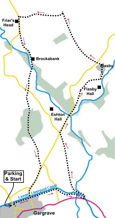
To view route as a dynamic Ordnance Survey map click here. Introduction: Gargrave is a “honeypot” village between Settle and Skipton on the A65 in North Yorkshire, very popular with day trippers. Contrary to what many believe, it is not within the Yorkshire Dales National Park boundary, which is why I have listed this walk under North Yorkshire, although most of it does fall within the National Park. The walk is a very easy one through pleasant rolling countryside with nice views. It starts with a stroll along the Leeds/Liverpool canal where, depending on the time of year, there is a good chance of seeing some boating activity and water birds. Flasby is a tiny hamlet, mentioned in the Domesday Book. Its main claim to fame in relatively recent times is that the famous Yorkshire cricketer Freddie Trueman lived there. The route passes some notable listed buildings, particularly Friars Head, a 17th Century farmhouse with great mullion windows. It is said to stand on the site of a monastic farm that once belonged to the monks of Furness Abbey. Also Brockabank, originating from a 17th Century farmhouse. Refreshments and public toilets are available in Gargrave along the A65. Some road walking on quiet lanes is involved. The walk starts from a free car park in Gargrave. To get to it, turn off the A65 at the Old Swan Inn on to North Street. The car park is a hundred yards or so on the right hand side. Start: Exit the car park and turn right to follow the fingerpost for the “Leeds Liverpool Canal”.
Turn right at the canal and along the towpath, crossing over the road at Ray Bridge. Stay on the towpath until you reach the locks (SD 944545), by the main A65. Cross the canal via the footbridge. Walk back along the opposite side of the canal in the direction you have come for a hundred yards or so, then cross a stone stile and follow the obvious path. Head to the left hand side of the trees in the centre of the field at the far side and cross a stile indicated by a yellow marker. Follow the right hand boundary in the next field, cross another stile and then keep straight ahead. Continue until you meet a broad track across the field and turn right briefly, before heading for the stile in the far left hand corner of the field. Cross the stile and turn left. Follow the path as it turns right at the corner of the field, then cross a stile on the left. In the next field, head towards the far right hand corner, towards where you can see a road junction. Cross a stone stile (SD 940556) and turn right along the road, following the road sign for Flasby. After crossing Eshton Beck, as the road bends left, go through a metal kissing gate on the right, following the footpath sign for Flasby (SD 942560). The path opens into a field. There is a fingerpost here which is a little misleading as it indicates following the left hand boundary. However it is the fence to the right which you need to follow up the hill. In the top right hand corner of the field cross a stile and after a few yards, turn right to follow a public footpath fingerpost. Walk down the field and on meeting the broad track to the farm, turn left. At the junction by the postbox (SD 947566), turn left and when the tarmac lane splits, take the right fork. At the ‘T’ junction, cross straight over by Flasby Top Cottage to follow the path indicated by a fingerpost for “Winterburn 1½ Miles”, following the left hand boundary.
Go through a 5 bar gate then follow the right hand boundary in the next two fields, then cross a stone step stile. The paths trodden in this field can be confusing. The official route (which I indicate via GPS) is to the far right hand corner, then turning left in the same field to follow the wall on you right. However in practice, it looks as though most people just make for the gate half way along the field. Through this, head for the diagonally opposite corner, then follow the wall and power lines downhill to the farm.
Join the road by the farm and turn left. You soon pass the fantastic Friars Head farmhouse. About 250 yards past Friars Head, as the road bends right, go left (in effect straight on) through a walkers gate (SD 933573). As you approach the trees, the footpath goes around the left hand side. There is an old lime kiln to the left.
As you approach the house (Brockabank), go through the gate to its right. The path then curves left in front of the house and when you reach its drive, turn right along it, crossing the river by a stone bridge. As the track starts to rise towards the next farm, go through the walkers' gate on the left (SD 934565). Keep straight ahead ignoring any paths off until you reach the road. At the road the route is almost straight ahead. A finger post indicates Gargrave 1¼ miles.
Go across the field to a stile in the left hand fence. Cross it and walk to the left of the power pole nearest to you at which point you should see another stile going into the trees via a kissing gate (SD 935560). The path through the trees is clear. As you exit the trees, head slightly left. Flasby Fell looks down on you from the left. Head for what looks like a jumble of posts/fence tensioners where there is quite an unusual metal stile. Cross and head for the far left corner of the field and on to the road. Turn right until you get to the Leeds Liverpool Canal. Go right and walk along the towpath to the next bridge. Go left along the road back to your starting point. If you need to buy any hiking equipment/clothing before your trip see the Hiking Store All information on this site is given in good faith and no liability is accepted in respect of any damage, loss or injury which might result from acting on it.
| | |||||||||||||||||

.jpg)
.jpg)
.jpg)
%20Lock%20gates%20at%20Gargrave.jpg)
%20View%20En%20Route.jpg)
%20Pendle%20Hill.jpg)
%20Approaching%20Friars%20Head.jpg)
%20Friars%20Head.jpg)
%20Lime%20Kiln.jpg)
%20Brockabank.jpg)