|
Gargrave
to East Marton
|
Starting
point and OS Grid reference:

Gargrave
- free car park on North Street (SD 932543)
|
Ordnance
Survey Map
OL2
Yorkshire Dales – Southern and Western Areas.
Buy this map from
List
of OS Maps
Note: If you use OS Maps on-line, you can download this route via this
link.
| |
Distance: 6.8
miles
| |
Traffic light rating:

(For explanation see My
Walks page)
| |


For advice on .gpx files see
My
Walks page
|

Click
the PDF logo above to give a printable version of this walk without the
photos.
|
To
view route as a dynamic Ordnance Survey map click here.
Introduction:
Gargrave is a “honeypot” village
between Settle and Skipton on the A65 in North Yorkshire, very popular with
day trippers. Contrary to what many believe, it is not within the Yorkshire
Dales National Park boundary.
%20Pennine%20Way%20markers.jpg) This very easy walk from Gargrave follows the
route of the Pennine Way across the fields to East Marton then returns to
Gargrave via the towpath along the Leeds Liverpool canal. As this walk uses
part of the Pennine Way, a plus is that it is well marked with fingerposts
or round signs on posts. The minus is that because of the popularity of the
Pennine Way, the areas around the stiles and gates can be very muddy after
wet weather. In fact after wet weather, many of the fields near Gargrave can
be quite “squelchy”. This very easy walk from Gargrave follows the
route of the Pennine Way across the fields to East Marton then returns to
Gargrave via the towpath along the Leeds Liverpool canal. As this walk uses
part of the Pennine Way, a plus is that it is well marked with fingerposts
or round signs on posts. The minus is that because of the popularity of the
Pennine Way, the areas around the stiles and gates can be very muddy after
wet weather. In fact after wet weather, many of the fields near Gargrave can
be quite “squelchy”.
Another plus for this walk is that if you
wish, you can forget the sandwiches and have lunch and a warm-up at the pub,
The Cross Keys at East Marton, or the Abbots Harbour restaurant and tea
rooms (check opening times). It
is therefore a good walk for inclement weather (despite the mud!) or cold
winter days.
The main potential hazard facing walkers on
this route is the unwelcome attention of aggressive swans in the nesting
season. They nest on the opposite side of the canal to the towpath but
fiercely guard their section of canal. Based on my experience, as long as
you do not linger in the area opposite the nest and keep walking, you should
not have a problem.
Refreshments and public toilets are available
in Gargrave along the A65 and of course refreshments at East Marton.
The walk starts from a free car park in
Gargrave. To get to it, turn off the A65 at the Old Swan Inn on to North
Street. The car park is a hundred yards or so on the right hand side.
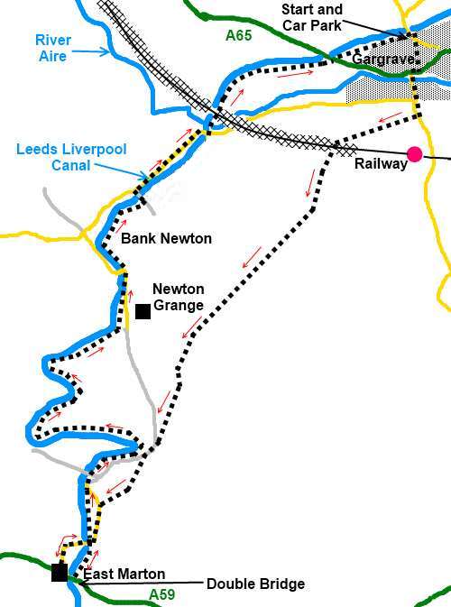
Start:
From the car park (SD 932543), set off in the direction of the fingerpost in the corner
towards the railway station and the church, passing in front of the village
hall on West Street.
At the main road (A65),
go straight across and over the river bridge.
%20Centre%20of%20Gargrave.jpg)
%20River%20Bridge%20at%20Gargrave.jpg)
Pass the church and 100
yards or so beyond, take the footpath on the right indicated by a fingerpost
“Pennine Way” and “Trenet Bridge 2 miles” (SD 932539). Opposite some
garages, go left over a stile and immediately right following the
fingerpost.
The Pennine Way is generally well marked but
note after going through the second metal walkers gate, the route of the
footpath in the next field can be a little indistinct. Just stick to the
left of the power cables and as you crest the rise, you will see the gate in
the corner with a fingerpost. Join a broad track through this gate and turn
left (SD 927537).
%20Gargrave%20with%20Flasby%20Fell.jpg)
Cross the railway bridge and follow the track
until just after a cattle grid (SD 925533). Here, go left over a stile then
follow the path bearing right up the field. Head for the fingerpost on the
near horizon. As you near it, the mass of Pendle Hill looms ahead. Continue
to follow the Pennine Way signs.
Cross and ignore a broad track leading to a
barn and Newton Grange. Continue along the right hand side of the fields and
look out for a footbridge across the stream. Cross this and go straight
ahead up the hill bearing slightly left – head between the two power
poles. You will then pick up the route of the path which passes around 200
yards to the right of the stone built house.
After crossing the flat top of the field, the
path descends to a walkers' gate. Go through this and on the broad track,
turn left then immediately right at the entrance to Trenet Laithe and over
the little bridge (SD 915518).
Stay on the main track until you reach the
turn on the left for “Pennine Way” and “East Marton ½ mile”. Follow
the path into the wood along a narrow walled path for the first few yards
then over a stile before turning right. The path follows the edge of the
wood briefly before bearing left across the field where you join a broad
track. Turn left here along the track.
Stay on this track and look out for a
“Pennine Way” sign on the left which points along the towpath. The route
to East Marton does not go along the towpath but straight ahead over the
bridge (SD 911511). However it is worth walking the 300 yards or so along
the towpath to see the very unusual double arched bridge which carries the
A59 over the canal. You could join the A59 here and walk along it to
the Cross Keys but it is a fast and for walkers a dangerous road so I
recommend retracing your steps to the Pennine Way fingerpost then turning
left over the canal bridge to follow the lane to the pub.
%20Canal%20Bridge%20at%20East%20Marton.jpg)
%20Double%20Bridge%20at%20East%20Marton.jpg)
%20Tranquil%20canal%20scene%20at%20east%20marton.jpg)
There are always a number of boats moored
here, some of which seem to have permanent residents.
After visiting East Marton, return to the
canal and turn right over the bridge and right again at the towpath to pass
under the same bridge to follow the towpath back to Gargrave. Note on the
way back, there are a couple of places where you briefly walk along the road
and rejoining the towpath means crossing a canal bridge then turning left
and back under it to rejoin the towpath.
You pass locks at Bank Newton.
%20Locks%20at%20Bank%20Newton.jpg)
The canal winds around some tight curves as
it picks its way along the contours of the land. Stay on the towpath as it
passes under the A65 road bridge. At the next bridge you reach, by lock
number 32, turn right along the road back to the car park.
If you need to buy any
hiking equipment/clothing before your trip see the Hiking
Store
All information on this
site is given in good faith and no liability is accepted in respect of any
damage, loss or injury which might result from acting on it.
|


.jpg)
.jpg)
.jpg)