
|
|
|
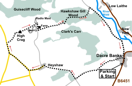
To view route as a dynamic Ordnance Survey map click here. Introduction: High Crag sits at the summit of Heyshaw Moor at 1086ft (331 metres), where there is a trig. point pillar, atop a gritstone outcrop. There are brilliant views over Wharfedale to the Pennines, as far as the edge of the North York Moors and up Nidderdale – or there should be! Contrary to Auntie BBC’s promises of sunny spells and scattered showers, we were met with persistent rain, a bitingly cold wind and poor visibility, although we could just make out the shadow of the NY Moors. The few photos I took can only give you a flavour of the potential views. Navigation can be quite tricky because there are numerous footpaths and in the plantations, foresters create tracks which are difficult to relate to the OS map. However, there is a radio mast which is a good reference point (SE 170632) and once you get to the disused quarry just past this, virtually any downhill route will put you in the correct valley to return to Dacre Banks. The walk started in Dacre Banks, an unassuming hamlet strung out along the B6451 from Otley to Summerbridge (just outside Summerbridge). The best thing about the hamlet is the Royal Oak pub which serves excellent beer and food. There is a public car park across the road from the pub which is where the walk starts. After wet weather, consider gaiters as there can be some muddy sections. Start: Exit the car park (SE 197619) and turn left to the main road then turn right for only about a hundred and fifty yards then turn left into Grange Road. As Grange Road bends left, take the narrow footpath off to the right, between the houses Up a few steps, turn left along a tarmac drive. Continue on this drive until you reach the end and look out on the left for a walkers’ gate. Go through this and turn right following the yellow arrow. Continue to another walkers’ gate and on joining a broad track, turn right. When the track splits at a farm, take the left fork then shortly right to a farm gate, following the Nidderdale Way fingerpost
Once through the gate, head for the diagonally opposite corner of the field. Go through a walkers’ gate and follow the left hand field boundary of the next two fields, again following the Nidderdale Way fingerpost. At the end of the second field (SE 189617), without going through the gate, turn right to follow the line of trees. Turn left through a close pair of walkers’ gates, then head slightly to the left of the centre of the opposite side of the field and cross a stone step stile there. Continue straight ahead on the broad track (Monk Ing Road). When you reach a crossroads of broad tracks, where there is a four way fingerpost (SE 182615). Turn right to follow the fingerpost for “Heyshaw”. At the end of the trees, turn left (second footpath) passing Lanes Foot Barn, along by more trees. At the end of the trees, continue in a straight line, heading for Heyshaw, the farm complex/hamlet you will see ahead, heading to the right of the large barn. Circle anti-clockwise round the farm, arriving at two stiles, either side of a broad track. Cross these and turn left. Follow the lane through the hamlet, avoiding any footpaths off it, and at the road junction, turn right (SE 168617). Follow the road for half a mile, then at a second road junction, turn right again (SE 162622). After less than a quarter of a mile, cross a stile indicated by a public footpath fingerpost and follow the path to High Crag (SE 165629). The trig point should be visible.
From High Crag, take the path to the radio mast. Just beyond it, the path reaches a wall and a ‘T’ junction of paths. Turn right here, following the Nidderdale Way. Just past the farm house, turn left through a farm gate (SE 171629). Do not go sharp left following the Nidderdale Way but head downhill, aiming for the gap between the plantations about half a mile ahead. About half way down the first field, the path veers off right to a point about half way along the approaching wall. Cross a step stile and through a gate at the end of the next field, to follow the obvious track. At a major junction of tracks, turn right. At a ‘T’ junction, turn, left (SE 186634). Continue down the hill, ignoring for after a few yards. The track drops down to another ‘T’ junction at a wall (SE 186636), turn right through a farm gate. If you need to buy any hiking equipment/clothing before your trip see the Hiking Store All information on this site is given in good faith and no liability is accepted in respect of any damage, loss or injury which might result from acting on it.
| | |||||||||||||||||

.jpg)
.jpg)
.jpg)
%20View%20over%20Nidderdale.jpg)
%20High%20Crag%20Trig%20Point.jpg)
%20Rocks%20at%20High%20Crag%20and%20view%20to%20Nidderdale.jpg)
%20View%20up%20Nidderdale.jpg)
%20Radio%20Mast%20at%20High%20Crag.jpg)