|
Crayke
to Oulston
Before
undertaking this walk, please see the attached annex.
|
Starting
point and OS Grid reference:

Roadside
rough lay-by half a mile beyond Crayke village (SE 567714)
|
Ordnance
Survey Map
OS
Explorer 299 – Ripon and Boroughbridge.
Buy this map from
List
of OS Maps
Note: If you use OS Maps on-line, you can download this route via this
link.
| |
Distance: 7.4 miles
| |
Traffic light rating:

(For explanation see My
Walks page)
| |


For advice on .gpx files see
My
Walks page
|

Click
the PDF logo above to give a printable version of this walk without the
photos.
|
To
view route as a dynamic Ordnance Survey map click here.
Introduction:
This walk is on the edge of the
Howardian Hills, an Area of Outstanding Natural Beauty. As the name
suggests, they are near the stately home Castle Howard, between the North
York Moors National Park, the Yorkshire Wolds and the Vale of York. The
overall area is some 79 square miles. Being at the edge of the area, this
walk provides extensive views across the Vales of York and Mowbray.
The first part of the walk, from the start to
Oulston, follows the Foss Walk, a Long Distance Footpath of some 28 miles,
running from York to Easingwold.
Crayke and Oulston are pretty villages built
on hilltops. Oulston has an attractive village green with a circular seat
under a tree, which provides a convenient sandwich stop. Crayke has the
Durham Ox pub which does food – the main entrance seems to be at the back
so it can be open when it appears closed. Crayke also boasts a castle, or at
least the remains of it, the main part now being a private house (walk up
Church Hill in the village if you want a look).
On the walk, you get one of the best views of
the Kilburn White Horse.
As the roads are quite narrow in the villages
and there is little parking room, I started this walk from a rough but good
sized, roadside parking area about half a mile north east of Crayke -
basically the continuation of the main street through the village. However,
as this is a circular walk, you could start at any convenient spot.
Crayke is most easily found by going east
from Easingwold, just off the A19. Crayke is signposted from Easingwold.
Just keep going, through Crayke for half a mile to find the parking on the
right, just after a “double bends” road warning sign.
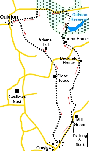
Start:
Turn right at the parking (SE 567714) and walk along the road for no more
than about 200 yards and turn left on the no through road (SE 567716). There
is a public footpath fingerpost indicating the way.
When the road forks after about 100m yards,
go right.
On a bend, where paths go off at both sides,
take the left path and follow the right hand field boundary. At the end of
the field, go through the kissing gate and turn right and at the tarmac
track, turn left (SE 567724). To be honest, you could probably just stay on
the road/track and not do this field section but the description is as per
the Right of Way (Foss Walk).
%20Howardian%20Hills%20view.jpg)
On reaching the farm (Woodfield Farm), do not
be seduced by the inviting track by the barns, as I initially was. There is
a grassy area in front of the farmhouse, almost like a village green. At the
end of that, the footpath forks off to the right. At the hedge, keep
straight ahead following the slightly raised banking.
At the end of the field, go through a narrow
gap in the hedge over a stile and again, keep straight ahead.
%20Howardian%20Hills%20View.jpg)
Over the next stile, head towards the left of
the next farmhouse (Beckfield House). You will soon see the fingerpost.
Follow the fingerpost direction for “Foss Walk - Pond Head 1 mile”.
After a few yards, the path forks off left across the field, to the next
stile which is visible, as is the next one and the footpath takes you to a
gate leading on to a road (SE 567736).
Cross straight over the road, following the
“Foss Walk” fingerpost. As you rise up the field, you will soon see
Burton House and its outbuildings. Head for the left of them. A yellow
waymarker close to the last stone barn guides you to a walkers’ gate,
which you go through and turn right.
A track leads you down to a stream which you
can cross via some square stepping stones. The path then curves to the right
to a gate with another waymarker. Through that gate, follow the line of the
trees to a second gate. There are two waymarkers here and you go straight
on, again following the trees.
Through the next gate, come to Oulston
Reservoir on the right. Follow the obvious path ahead through the trees and
eventually past Pond Head Farm. Turn left along the drive to the farm to the
road and turn left along it (SE 565748).
%20Oulston%20Reservoir.jpg)
%20Oils%20seed%20rape%20fields.jpg)
Walk along the road for half a mile (ignore
the fingerpost on the left after about a quarter of a mile), to just past
the end of the woods on the right. There are far reaching views to the south
from this road. Look out for a public footpath fingerpost on the left (SE
556749). You turn off the road here but before doing so, if you look north,
there is one of the best views you are likely to get of the White Horse at
Kilburn.
%20White%20Horse%20at%20Kilburn.jpg)
Follow the broad track to Whincover Farm and
at the gate, without going through it, turn right following the fingerpost.
The path which will continue your walk is off
to the left at the end of the second field but it is worth having a look at
the village and perhaps pausing at the picturesque village green for your
picnic. On this assumption, follow the path in a straight line to the
impressive building Oulston Hall. The footpath runs between the house itself
and the barn. At the road, turn left.
%20Distant%20Views%20at%20Oulston.jpg)
%20Village%20Green%20Oulston.jpg)
After visiting the village, retrace your
steps past Oulston Hall and as the track dips down, turn right to follow the
broad track (SE 550745), off the one on which you arrived. It curves left to
a gate. Go through this and cross the field to the stile opposite.
The route is now clear, being marked with
yellow waymarkers and prominent stiles. There are fine views to the south
west.
%20Looking%20back%20at%20Oulston%20village.jpg)
You crest the brow of a hill (SE 553739),
where there are newly planted trees (as at 2014). There are views over the
Vale of York. Look out for two stiles close together just over the brow.
Cross these and head for about the centre of the left hand side of the
field. The church tower of Crayke is visible on the hilltop to the right, as
you cross the field.
%20Distant%20views%20over%20Vale%20of%20York.jpg)
Go through a gate, across the drive to the
farm ((Adams Hall) and through another gate over the next field. Bear
slightly right to a stile in the hedge, which may not be easy to spot. Over
this, head for the diagonally opposite corner of the field.
Go through a small gate and cross the road
(SE 561733) to follow the next fingerpost for “Crayke”, along the left
hand field boundary. At Close House Farm, cross between the house and the
barns and through the gate opposite. Go through a double set of gates and
bear slightly right. As you get further along the field, there is a slightly
raised area and you should be on top of this following the right hand side
of a row of trees. Go through two stiles and over a small wooden bridge, at
the end of the field.
Follow the right hand boundary of the next
field and at a three way post of waymarkers, keep straight ahead. About two
thirds of the way along the field, the route branches off left at about 30°
to a post with a yellow waymarker. Follow its direction to a broad track (SE
563716) and turn right and quickly left to follow a yellow waymarker.
You will probably notice the clear path
climbing the hill to Crayke, via a walkers' gate on the left, across a
grassy slope. There are good views here. Follow the path past the houses to
the road. Here, turn right to see the village or left to return to the
parking place.
%20Approach%20to%20Crayke.jpg)
%20Old%20Cottages%20at%20Crayke.jpg)
%20Centre%20of%20Crayke.jpg)
If you need to buy any
hiking equipment/clothing before your trip see the Hiking
Store
All information on this
site is given in good faith and no liability is accepted in respect of any
damage, loss or injury which might result from acting on it.
|


.jpg)
.jpg)
.jpg)