|
Caldberg
and Witton
Moors
|
Starting
point and OS Grid reference:
Car
park at Gollinglith Foot (SE 154810)
|
Ordnance
Survey Map
OL
30 – Yorkshire Dales – Northern and Central Areas
OS Explorer 302 - Northallerton and Thirsk.
Buy these maps from
List
of OS Maps
Note: If you use OS Maps on-line, you can download this route via this
link.
| |
Distance: 11.9 miles
| |
Traffic light rating:

(For explanation see My
Walks page)
| |


For advice on .gpx files see
My
Walks page
|

Click
the PDF logo above to give a printable version of this walk without the
photos.
|
To
view route as a dynamic Ordnance Survey map click here.
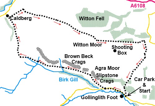
Introduction:
This walk circumnavigates Caldberg and Witton Moors above Wensleydale. It
may be regarded as a test of navigational skills as there are few
fingerposts or other significant markers. Many of the paths cross moorland
and as this is obviously a little walked route, there is scant evidence of
some of the paths on the ground, even though they are marked on the Ordnance
Survey map. Some of the paths are not public footpaths as such but cross
Open Access land and are marked on the OS maps as black dotted paths.
The route falls off
the eastern edge of the Yorkshire Dales Northern and Central map so for full
coverage, you need the OS Explorer 302 - Northallerton and Thirsk map too
(1:25000 scale maps).
The walk may be
most attractive in late summer, due to the large expanses of heather which
would be in flower. However, this moorland is clearly an actively managed
grouse shooting area so there may be restrictions during the grouse season.
Also, later in the summer, tall bracken may make route finding difficult.
The management
involves periodic burning of the heather and this seems to have resulted in
paths migrating somewhat.
The walk starts at
the delightfully named Gollinglith Foot. To get there, turn west off the
A6108 at Masham signposted for Fearby and Healey. After passing through the
hamlet of Healy, go right at a fork signposted Colsterdale. After just over
a mile, park at some rough parking on the left by a phone box.
Start:
Turn left out of the car park (SE 154810) and walk along the road for ¾
mile ignoring a track and a little rough parking on the right after ½ mile.
Turn right off the road by an old metal gate where blue arrows indicate a
public bridleway (SE 143814).
Join
a broad grassy track from the right and turn left.
%20Looking%20towards%20Colsterdale.jpg)
After
going through a gate (SE 141816), after only a few yards, fork off to the
left on a faint track through the heather. This is very difficult to spot,
even though it is shown as a public bridleway
on the OS map. As a little used track, this is quite overgrown and the best
guide is that it runs more or less parallel with Birk Gill in the little
valley below on the left. As long as you follow this principle and do not
actually descend into the valley, you will be more or less on track. The
faint path appears and disappears along the way.
%20Slipstone%20Crags.jpg)
The
path descends to Brown Beck (SE 136821) where there is a post with a white
top, one of a series which seem to mark the course of the beck - not your
route! Climb the bank at the far side. Further on you cross another small
stream.
%20View%20along%20Birk%20Gill%20Valley.jpg)
%20Brown%20Beck%20Crags.jpg)
Continue
across the heather, still parallel with Birks Gill, look out for a thin post
with a white top on the near horizon at SE 103830 (see photo) but this is a
faily flimsy affair and I cannot vouch for its permanency. Keep straight
ahead and no more than about 150 yards beyond here, reach a clear broad
track at SE 102831. Turn left.
%20Marker%20post%20referred%20to%20in%20text..jpg)
%20Rocks%20at%20Long%20Side.jpg)
%20Looking%20Back%20down%20Birk%20Gill.jpg)
Follow
this track as it swings in a clockwise arc and follow it all the way to the
outskirts of the hamlet of Caldberg (SE 094850).
%20View%20across%20Coverdale%20to%20Penhill.jpg)
%20Approaching%20Caldberg.jpg)
As
you reach it, turn right on another broad track, keeping the wall on your
left. Pass and ignore the broad track on the right to Ings Farm and continue
straight ahead, through a gate passing a barn on the left.
As
the track branches left to a farm, continue straight ahead through a gateway
then fork right (Se 102854) to the right hand boundary of the field and
follow it round to a gate (SE 103853).Go through this and turn left.
Look
out for a broad ascending grassy track on the right after 100 yards or so
and stay on this as it climbs the moor. As the path starts to level out, it
runs parallel with a little valley on the left hand side, along which runs a
wall.
Climb
over a plain wire fence (this is easiest done at a fencepost where a bracing
strut provides a step). The path across the moor is now virtually invisible.
As you come in sight of a small rounded hill topped by trees, you should see
the makings of a green grassy track over to the right. You cross a line of
wooden grouse butts.
Look
out for the remains of a stone building by some mining remains and head for
that. Beyond this the broad track is obvious.
On
reaching a broad track which goes left to some trees, turn right. Now stay
on this track without deviating, passing, at SE 147838, the track to a
shooting box on the horizon to the right.
Pass
a wood on the left and go straight ahead through a gateway. There are good
views ahead towards the North Yorkshire Moors.
Pass
the entrance to Moor Cote Farm (SE 163838) and no more than 50 yards further
on, turn right on to a faint grassy path as you get to the trees. There is a
drainpipe covered with gravel to aid passage across a gully. At the top of
the ridge, head along the little valley and take the track rising out of it
on the right.
After
a short shallow climb, the track swings round to the left, passing a heap of
discarded stones. Follow this track to a small mound with what could be a
rough stone cairn on its top. Circle round this to the left, passing a
subterranean stone construction. You should be walking parallel with a
derelict stone wall to your left.
As
the wall comes across to meet you, head towards the gate at the end of the
trees (SE 134830). Go through it and turn right to follow the wall along the
obvious path passing the Tranmire boundary
stone (SE160827).
There are now some marker posts which lead the way.
%20Boundary%20stone.jpg)
Reach
a gate where a yellow arrow indicates you bear left. Head diagonally towards
the trees (SE 156819) and go through the gateway, turning right to follow
the track along by the wood.
Follow
the marker arrows as the path heads downhill and under some power lines,
then enters a wood through a gate. It swings right through the trees before
exiting through a gate. Go left and follow the clear track to where you
parked the car.
If you need to buy any
hiking equipment/clothing before your trip see the Hiking
Store
All information on this
site is given in good faith and no liability is accepted in respect of any
damage, loss or injury which might result from acting on it.
|


.jpg)
.jpg)
.jpg)