
|
|
|
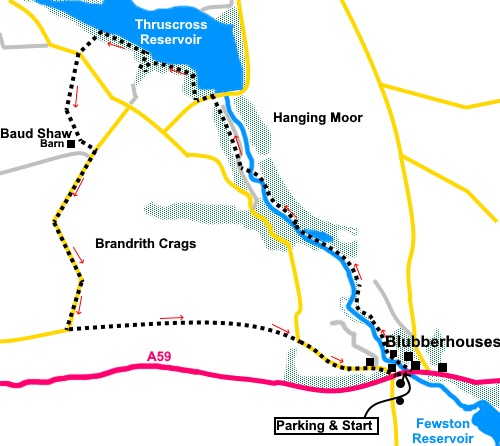
To view route as a dynamic Ordnance Survey map click here. Introduction: Although I have walked in and around the Washburn valley and its reservoirs on many occasions, I had never previously walked this stretch of the river Washburn. Charged with coming up with an easy, roughly 5 mile walk, with some friends, this seemed the perfect excuse to rectify the omission. Should you wish a longer outing, this walk can be linked with my Thruscross Reservoir walk. Contrary to what you might think, ‘Blubberhouses’ has nothing to do with whales or whaling. It is after all, quite a way from the sea! The name originates from an Anglo-Saxon word meaning ‘houses at a bubbling (or blubbering) stream’, the stream in question presumably being the River Washburn. The ‘village’ is little more than a sprinkling of properties, though at one time had a five storey flax mill, utilising water power provided by the river. Boom, then bust resulted in its closure and demolition in 1877 and its stone used to build the wall round Fewston Reservoir. The village lacks an identifiable centre but does have a cricket field which you will pass on the walk and pretty St. Andrew’s Church, which is Grade II listed and was built in 1851. The walk follows the course of the River Washburn, north from Blubberhouses, passing Low Dam, no doubt a source of power for the mill. This section of river has been popular with canoeists, its frequent low level being compensated for by occasional releases of water from the dam, ensuring white water conditions. The walk starts from a Yorkshire Water car park on the A59 at Blubberhouses, adjacent to the church, mid way between Harrogate and Skipton. Start: Very carefully, cross the busy A59 at the car park entrance and turn right behind the crash barrier. After a few yards, take a footpath on the left indicated by various arrows on a post, to follow the right hand bank of the river.
Pass Blubberhouses cricket ground.
At SE 162564, pass Low Dam.
Pass a three way fingerpost by a stone seat and keep straight ahead following the “Six Dales Trail” and “Thruscross Reservoir ¾ mile”.
At SE 157569, cross a bridge and turn right to continue following the river. Just below the imposing wall of the Thruscross Reservoir dam, you arrive at its service road. Cross this and take the path which climbs steps through the trees opposite.
Continue straight ahead until you reach the end of the dam (SE 154574). Turn left along the road, perhaps after venturing along the dam itself to look over the reservoir and to its right, its spillway.
After about a hundred and fifty yards, just after a car park, turn right along a broad track through the trees.
Look out for a footbridge on the right and cross this, continuing round the reservoir. Continue until you reach a footpath sign on the left for a permissive path through the trees, indicated by a green Yorkshire Water arrow (SE 156579). The path bears right on to a broader track. Follow this to the road, then turn left for a few yards to a stone step stile on the right, marked with a yellow footpath arrow. Roughly follow the right hand field boundary. Cross a dilapidated stone wall – there is a gap at its right hand end – then continue through a gateway, following the yellow arrow. Go through a metal gate, then bear left to the stone barn visible ahead. The path deviates a little from the direction on the map, to navigate round the grass type rush which often indicates boggy conditions but just aim to arrive at the barn (Baud Shaw) (SE 144571). Pass close to the left hand end of the barn and continue ahead through the gate ahead. Follow the wall as it bends to the right and continue, through a slit stile alongside the gate, to the road. Turn right along it. (Note: according to the OS map, the path runs along the right hand side of this wall as you approach but I followed the easiest way dictated by a clear track).
# Follow the road for just under a mile, past a distinct right then left bend. At the second right turn, turn left along a broad track (SE 144557). There is a small lake on the left just before the turn.
Follow this track for one mile to meet a road. Turn right along this road for half a mile, back to the car park. If you need to buy any hiking equipment/clothing before your trip see the Hiking Store All information on this site is given in good faith and no liability is accepted in respect of any damage, loss or injury which might result from acting on it.
| | |||||||||||||||||

.jpg)
.jpg)
.jpg)
%20St%20Andrews%20Church.%20Blubberhouses.jpg)
%20View%20over%20the%20cricket%20field%20at%20Blubberhouses.jpg)
%20River%20Washburn.jpg)
%20Low%20Dam.jpg)
%20Waterfall%20on%20River%20Washburn.jpg)
%20Thruscross%20Reservoir%20Dam.jpg)
%20Outflow%20from%20Thruscross%20Reservoir.jpg)
%20Looking%20across%20Thruscross%20Reservoir.jpg)
%20View%20North%20from%20the%20road%20from%20Thruscross.jpg)
%20Small%20lake%20by%20the%20roadside.jpg)