|
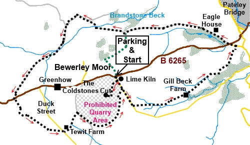
Bewerley
Moor and The Coldstones Cut
|
Starting
point and OS Grid reference:

Free car park at Toft Gate (SE 129644)
|
Ordnance
Survey Map
OS
Explorer 298 - Nidderdale.
Buy this map from
List
of OS Maps
Note: If you use OS Maps on-line, you can download this route via this
link.
| |
Distance: 9.2 miles
| |
Traffic light rating:

(For explanation see My
Walks page)
| |


For advice on .gpx files see
My
Walks page
|

Click
the PDF logo above to give a printable version of this walk without the
photos.
|
To
view route as a dynamic Ordnance Survey map click here.
Introduction:
This walk near Pateley Bridge is a
circuit of Bewerley Moor which passes various mining remains and visits The
Coldstones Cut, a massive stone sculpture created by the artist Andrew
Sabin. You are able to walk through this to viewing areas. The lower area
takes you to a viewing platform which overlooks the colossal Coldstones
Quarry at Greenhow Hill. At 1,400 feet above sea level, this is one of the
highest quarries in Britain. There are information boards about quarrying,
mining and the geology of the area. No ground level photo can do justice to
the sculpture and I indebted to Paul Harris for permission to use his aerial
shot - see below.
At the higher level of the sculpture, an
orientation plate around the wall tells you what you can see in the
distance. The North York Moors are visible, and there are views along
Nidderdale and across to Wharfedale.
Also here is the Toft Gate Lime Kiln, built
around 1860. Information boards tell you about the history and the lime
making process.
I worked out this route from a map and
inadvertently found I was in part following around two thirds of the
Bewerley Industrial Heritage Trail. This provides information via notice
boards about some of the old mining sites visited.
The walk starts from a free car park (SE
129644) on the B6265 at Toft Gate, at the junction with a minor road. To get
there, take the B6265 west from Pateley Bridge. The car park is on the left
after 2 miles.
Coming towards Pateley Bridge from the west,
the junction where the car park is positioned is the first on the right, a
mile beyond Greenhow.
There is an option to shorten the walk about
half way round – see green dotted route on the sketch map.
Start:
Take the obvious path from the rear of the car park following the fingerpost
for The Coldstones Cut. At the fork a few yards later, go left for the Toft
Gate Lime Kiln. You can still see the remains of the long flue and chimney.
%20Toft%20Gate%20Lime%20Kiln.jpg)
%20Toft%20Gate%20Lime%20Kiln%20Chimney%20and%20views%20to%20wharfedale.jpg)
Follow the path around the kiln and at the
lane, cross over to follow the fingerpost for The Coldstones Cut. The path
climbs the moderate slope and you walk through the “street” up the
middle of the sculpture.
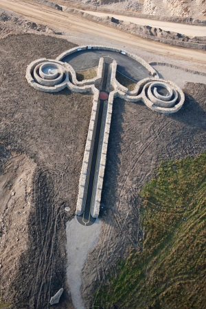
Aerial Photo of Coldstones Cut
Reproduced by Kind Permission of the Photographer, Paul
Harris
%20Coldstones%20Cut%20Sculpture.jpg)
%20Coldstones%20Quarry.jpg)
%20Looking%20up%20Nidderdale.jpg)
Return to the lane by the kiln and turn
right, to walk along it for just under half a mile. Turn left at the start
of a copse of trees to follow the fingerpost for “Public Footpath to
Pateley Bridge” (SE 133638).
As you drop down, it can be quite hard to
spot the route and stiles, amongst the broken down walls. Keep to the right
of a ruined barn and in the field beyond, head for the opposite right hand
corner where you will find the stile. Beyond this stile, keep to the right
of the little valley, along its top.
At the tarmac track, turn left.
At the farmhouse, fork right through a metal
gate.
After crossing a ladder stile, head to the
left of a tall upright stone ahead of you, then to the left of the cluster
of buildings beyond and through the five bar gate.
Once through this gate, the route has been
diverted and you go left through a small walkers’ gate. There were some
fierce dogs going ballistic at my presence, in the grounds of the farm here
(Gill Beck Farm) (SE 144640) but thankfully, they seemed to be securely
contained behind mesh fencing.
The route round this farm is obvious and you
drop down to a broad track go straight ahead ignoring the right hand turn,
staying on the Bewerley Industrial Heritage Trail which is marked with
yellow arrows. The path opens into a large field. Keep to the left hand
boundary and pass Moor View Farm. Follow the main farm track.
At the next property (Haver Garth), fork
right, following the main track (SE 149645).
After passing the next farm (Wood Farm), turn
left along the barn like structure then turn right at its end. In the field,
the path is not obvious but go diagonally across it, heading roughly to the
right of Pateley Bridge below you. As you get to the point where the field
starts to drop away from you quite steeply to the left, look out for the
narrow slit stile in the stone wall, towards the bottom of the copse of
trees.
Through the stile, head down through the
trees and at the stream, turn left through the walkers’ gate. At the next
gate is a superb view across Pateley Bridge and up Nidderdale. Go through
the gate and head downhill, towards the bottom right hand corner of the
field, where there is a wooden deck/bridge to cross the stream. At the
bottom right hand corner of the field, turn left along the lane (se 155651).
%20View%20Over%20Pateley%20Bridge.jpg)
At the B 6265, cross carefully and head along
the tarmac track following the fingerpost for “Public Bridleway,
Nidderdale Way and West Lane”. You follow the tarmac for a couple of
miles, passing Eagle Hall before the track reverts to rougher stone. There
are good views along here.
%20Nidderdale%20way%20near%20Eagle%20House.jpg)
%20Looking%20up%20Nidderdale.jpg)
%20Rainbow.jpg)
At (SE 131653), ignore the left turn
signposted for Toft Gate, unless you want to shorten the walk (see green
dotted route on the sketch map).
After crossing a stone bridge over Brandstone
Beck, the path branches left in front of Hollins Hill House.
Join another broad track and turn left. There
is now open moorland to the right.
At a three-way fingerpost, turn left for Cock
Hill Se (SE 121658).
When the track forks on a bend, keep right
and at a ‘T’ junction of tracks, turn right.
After crossing a ford, arrive at an old
mining area with a well maintained building at its centre. Follow the path
to the left of the building and keep a look out on the left for the old
entrance to The Cockhill Lead Mine. This leads to 8/9 miles of underground
tunnels, driven in 1782. DO NOT ENTER as the mine is not safe. A notice
board tells you that there are some unusual flora to be seen on the spoil
heaps here.
%20Cockhill%20Lead%20Mine.jpg)
%20Entrance%20to%20Cockhill%20Lead%20Mine.jpg)
%20Cockhill%20Mine%20Chimney.jpg)
Do not
cross in front of the mine. Instead, at it, turn around to face the way you
have come and turn right to follow the ascending path. The path soon follows
the left hand top of a valley. On the hill to the right, you can see the
remains of the old chimney.
Follow this track as it climbs and after
passing a farm, keep straight ahead – i.e. do not turn left to follow the
farm’s track.
At the next farmhouse, again keep more or
less straight ahead again, through a gate and into a walled track. The track
passes some old mine shafts, recognisable as mounds with rings of fencing to
prevent animals falling in, before emerging at the B6265 at Primgap Farm.
Turn right for a few yards then left on a
broad track following the fingerpost for “Duck Street”(SE 107640).
Follow the track as it meanders amongst the old spoil heaps. It is not easy
to spot the continuation of the public footpath, through the spoil heaps. If
you miss it, keep on the broad track. When it joins the drive to a
farmhouse, turn right and right again at the road.
At Tewit Farm (SE 133638), follow the
fingerpost for “Toft Gate”. The path has been diverted around the farm
and once past the farm, the path across the fields is clear, emerging via an
awkward stile into a quarry road. Watch out for the lorries!
Cross the quarry road to the public footpath
fingerpost and turn right following the fences footpath, initially parallel
with the road. The path then bends gradually left around the perimeter of
the quarry property. There are good views here across to the Menwith Hill
domes and Wharfedale beyond.
Continue to follow the path until you reach a
small path branching off to the right. Join the road by a small barn and
turn left along it, to return to the car park.
If you need to buy any
hiking equipment/clothing before your trip see the Hiking
Store
All information on this
site is given in good faith and no liability is accepted in respect of any
damage, loss or injury which might result from acting on it.
|


.jpg)
.jpg)
.jpg)