
|
|
|
To view route as a dynamic Ordnance Survey map click here. Introduction: The
word “bimble” means “to move at a leisurely pace”,
which is an accurate approach to take to this short, gentle meander round
pleasant countryside, to the south-west of Harrogate. It is also makes for a
nicely alliterative title! Beckwithshaw
is an elongated village whose main features are The Smiths Arms pub (open
all day!) which can provide welcome refreshment after the walk and St
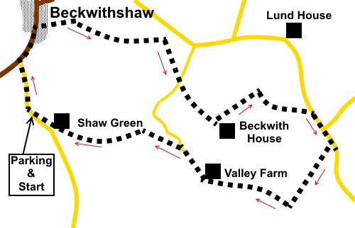
Michael and All Angels Church. This church is Grade II listed on account of its Gothic architecture, dating from the 1885/86 and some high grade fixtures and fittings and stained glass. The stained glass was designed by a Charles Edward Kempe, who was a well known Victorian stained glass artist. The church is an example of an Arts and Crafts church retaining original furnishings. Unfortunately, it was locked up at the time of my visit. The walk starts from Beckwithshaw village. There is parking on the main street but this is quite a busy road and I chose to park on Shaw Lane, about a quarter of a mile from the B6161 junction, just past the bend, where the pavement ends. Please ensure you do not block any gateways. The walk brings you back to this spot. There are no facilities en route. Start: Walk north along Shaw Lane to Beckwithshaw and at the junction with Otley Road (the B6161), turn right into the village.
Walk along the right hand side of the road, and turn right immediately before the church of St Michael and All Angels, over a slit stile in the wall and down the footpath indicated by a fingerpost (SE 268531).
At the field, initially follow the left hand boundary for a few yards to the fence corner, then keep straight ahead. At the far end of the field, cross a stone step stile to a stony track. Immediately across the track, cross a gated step stile, which actually enters a private garden but this is the footpath route. Keep to the far right and follow the stream. At the far end of the garden is a stile which takes you into a field. Follow the right hand boundary. At the end of the field, cross the stile in the right hand corner and continue to another in the right hand corner of the following field. In the next field, follow the left hand boundary, passing a barn, to a stile in the left field corner. Go through a walkers’ gate ahead (SE 277530) some 40/50 yards before a bungalow. You now have choice. You can cut off a small corner by taking a footpath route to the left of the bungalow (past the little stable) and then via a gravel drive to join Howhill Quarry Road or you can turn left at the walkers’ gate and follow the left hand field boundary to the road (Howhill Road). Here, turn right then right again at the junction to walk down Howhill Quarry Road. I did the latter as there is a lovely view to the right, towards Beckwithshaw as you walk down Howhill Quarry Road.
Look out for a public footpath fingerpost on the left, about two hundred and fifty yards from the road junction, along a broad track to Low House Farm (SE 278528). Follow the track between the farm buildings to a walkers’ gate and continue straight ahead in the field beyond to a kissing gate. The route to the next gate is clear. Through this, the path climbs a short bank to another kissing gate and through this bear left to the far left corner of the field. Go through yet another kissing gate, then as you pass the house, turn right to follow the drive. Pass the entrance to Beckwith House (SE 281525) and walk through the tiny scattered hamlet of Beckwith.
Follow the lane and look out for a fingerpost on the left but pointing right through a slit stile for the Harrogate Ringway (SE 283527). The Harrogate Ringway (a 20 mile circuit of Harrogate) is well signposted with yellow arrows bearing a sketch of the Royal Pump Room. Follow this until you arrive at a road (Lady Lane) by Blue Cote Farm. Turn right along the road. Lady Lane becomes Hill Top Lane and about a hundred and fifty yards after the change, just after a farm, look out for a public footpath fingerpost on the right (no longer the Harrogate Ringway) (SE 288523).
Follow the path, marked with yellow arrows, downhill between the hedges and straight ahead after the gateway, down a long field. As the path descends, there are some nice views. Pass through a gateway and down another long field, with good views of the majestic Beckwith House to the right.
Go through a gate at the bottom of the second field. Only ten yards or so after the gate, look out for a “crossroads” of paths and turn right (SE 285520). It is easy to miss this path and it is more easily spotted by looking left. The route is now marked by stiles and yellow arrows and you get another stunning view of Beckwith House and realise what stunning views it must have! Immediately after passing to the right of a pond (SE 281520), the path curves left to Valley Farm. On arriving at the tarmac art Valley Farm, turn right. About two hundred and fifty yards after the farm, there are some white railings by a bridge over the stream. Just before these, fork off left up a footpath (SE 278523), indicated by a fingerpost. Follow the path as it opens into a field and continue ahead to a gate close to a power pole. Through this gate, follow the right hand boundary on the next two fields. Cross a double stile arrangement and turn left to follow the well worn path to a stile alongside a gate. Cross and follow the left hand boundary. After passing some barns, arrive at a gated step stile to the right of a rough drive. Cross and follow the yellow arrow. Keep to the left hand boundaries and after a couple of obvious stiles, turn right along Shaw Lane (SE 269525) back to the car.
If you need to buy any hiking equipment/clothing before your trip see the Hiking Store All information on this site is given in good faith and no liability is accepted in respect of any damage, loss or injury which might result from acting on it.
| | |||||||||||||||||

.jpg)
.jpg)
.jpg)
%20Smiths%20Arms,%20Beckwithshaw.jpg)
%20St%20Michael%20&%20All%20Angels%20church.jpg)
%20Countryside%20view%20near%20Beckwithshaw.jpg)
%20View%20from%20Howgill%20Quarry%20Road.jpg)
%20Another%20view%20from%20Howgill%20Quarry%20Road.jpg)
%20Harrogate%20Ringway%20sign.jpg)
%20View%20descending%20from%20Hill%20Top%20Lane.jpg)
%20Beckwith%20House.jpg)
%20A%20sign%20to%20gladden%20a%20Yorkshireman's%20Heart.jpg)