
|
|
|
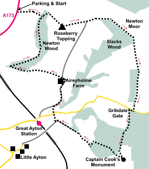
To view route as a dynamic Ordnance Survey map click here. Introduction: Roseberry Topping is the distinctive “Toblerone” shaped peak on the edge of the North York Moors, visible form many vantage points and even once used as a navigation aid by sailors, as it is visible from the North Sea. It has a summit of sandstone which through erosion and quarrying has reduced a little over the centuries but it still stands out and has just managed to remain over 1000ft, being 1050ft (320 metres). Its pointed shape ensures fabulous 360° views from its summit and it was a popular tourist attraction in Victorian times. The remains of an old handrail are still there. In 1912, there was a major rock fall, variously attributed to a geological fault, excessive mining and/or very heavy rain. Whatever the cause, it has left a sheer rock wall on its south-west face. The net result is a fascinating route around a hill which changes its shape as you walk circumnavigate it. Having climbed Roseberry Topping, this walk then circles round the edge of Great Ayton Moor, following the Cleveland Way, to reach Captain Cook’s Monument on Easby Moor. Made of local sandstone, at 51 ft high, it was erected in 1827, to commemorate the local boy made good, Captain James Cook, who was born in Marton-in-Cleveland and went to school in the village of Great Ayton, just below Easby Moor. He was famous for his worldwide oceanic exploration. During the walk there are constant good views of Roseberry Topping itself, the surrounding countryside and across to the Wainstones, Cringle Moor and Hasty Bank. The walk starts with a steep climb to the summit of Roseberry Topping. The going after that is straightforward. If caught on top in poor visibility, it is important to leave it in a north-easterly direction as anything opposite is likely to lead to a long fall! Much of the path on this walk has been “manicured” with stone slabs/rocks to protect against erosion. However there are some sections prone to mud after rain, in which circumstances, you will be grateful for gaiters! The walk starts from a North York Moors National Park parking/picnic area next to the A173 about a mile and a half north-east of Great Ayton – Newton Under Roseberry Pay and Display. There are toilets here although they were closed at the time of my visit. I don’t expect anyone needs a toilet on a cold winter’s day! Start: From the car park (NZ 571129) and with your back to the A173, head to the rear left hand corner of the car park and turn right along the broad bridleway. Continue to a gate and through this, climb the rough steps through the trees. At the top of the steps, join a broad path and turn right.
Follow this steep but clear path to the summit trig. point (NZ 579126).
From the summit, head down in a NE direction (066° magnetic) into the little valley, heading for the pointed hill opposite. The main path skirts round the right hand side of this hill. Follow it to the next summit on Newton Moor, where you go through a walkers’ gate. Turn right, following the Cleveland Way (NZ 588128).
The route follows the edge of the escarpment, alongside a wall. There are constant good views to the right (west) and left (east) over the moors.
The path drops down to Gribdale Gate where there is a car park (NZ 592110). Turn briefly right at the tarmac and, after only a few yards, turn left to follow the fingerpost for “Cleveland Way” and “Kildale 2½ miles”.
The path climbs gently to the monument which you cannot easily see, other than the odd glance, until you get close to it. The monument (NZ 590101) has on its side a rather nice tribute to Captain Cook, describing him as “A man in nautical knowledge inferior to none; in zeal, prudence and energy, superior to most”. After further significant mentions of his life, it ends with “As a token of respect for and admiration of that great man”. I am humbled.
There is a spectacular profile of Roseberry Topping from the vantage point of Cook’s Monument.
To continue the walk, facing back the way you have come, take the path off at about 30° to the left (not the one more at 90°). After a short distance, go through two stone gateposts. A further 150 yards or so on, when the path forks, go left.
Follow the quite steep path down through the trees. At a crossroads of paths, keep straight on to a five bar gate from where the route curves left, following a wall on the right. Follow the wall to a corner and turn right here to follow a broad track (NZ 584104). Continue for about half a mile until you join the drive to a house. Turn right here. When the drive divides, take the right fork. The drive becomes a tarmac lane which leads to a crossroads. Go straight ahead here along Aireyholme Lane (NZ 577110). Stay on the lane for about half a mile to Aireyholme Farm (NZ 580116). Turn left immediately after the farm buildings. At the edge of the farmyard, keep straight ahead, following the old style public footpath sign (avoid the right pointing arrow). Arrive at a cottage. The path goes to its left, to follow the right hand side of a field, indicated by a public footpath arrow. Follow the right hand boundary of the next field too.
At the end of the field, go through a walkers’ gate and continue straight ahead through the trees, avoiding the right turn immediately after the gate. Keep straight ahead also at a faint crossroads of paths. Follow the path down until it meets another at the edge of the trees. Turn sharp right here NZ 569119). You now walk more or less parallel with the edge of the trees for almost a mile. There are a number of turns off to the right but stay with the nearest path to the edge of the trees. Eventually, you will join the path where you started the outward journey, recognisable by the rough steps to the right, which you ascended. Turn left here back to the car park. If you need to buy any hiking equipment/clothing before your trip see the Hiking Store All information on this site is given in good faith and no liability is accepted in respect of any damage, loss or injury which might result from acting on it.
| | |||||||||||||||

.jpg)
.jpg)
.jpg)
%20Roseberry%20Topping%20From%20Near%20start.jpg)
%20View%20to%20Teeside.jpg)
%20Summit%20of%20Roseberry%20Topping.jpg)
%20View%20to%20North%20Sea.jpg)
%20View%20SE%20From%20Roseberry%20Topping.jpg)
%20View%20south%20to%20Captain%20Cooks%20Monument.jpg)
%20View%20back%20to%20Roseberry%20Topping%20from%20Newton%20Moor.jpg)
%20Further%20view%20of%20Roseberry%20Topping.jpg)
%20View%20NE%20from%20Captain%20Cooks%20Monument.jpg)
%20Captain%20Cook's%20Monument%20with%20Roseberry%20Topping.jpg)
%20Path%20to%20Captain%20Cook's%20Monument.jpg)
%20View%20SE%20to%20Cringles%20Moor%20and%20Hasty%20Bank.jpg)
%20Looking%20back%20to%20Captain%20Cook's%20Monument.jpg)
%20A%20final%20view%20of%20Roseberry%20Topping.jpg)