
|
|
|
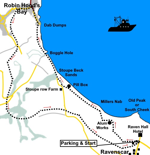
To view route as a dynamic Ordnance Survey map click here. Introduction: This walk follows what I think is one of the most interesting and picturesque sections of the East Yorkshire coast. It is a very easy navigation requiring almost no instructions because you simply follow the Cleveland Way to Robin Hood’s Bay and the Cinder Track to return to Ravenscar. There is the option of a beach walk section from Stoupe Beck Sands to Robin Hood’s Bay but you must, repeat must be sure of the tides as it is very easy to get trapped. The cliffs are extremely friable and any attempt to climb them is likely to end in tragedy. In 2020, I was enjoying a pint in the Bay Hotel in Robin Hood’s Bay (highly recommended by the way), when the inshore lifeboat had to be deployed to rescue someone, who had become trapped in this way. You have been warned! I describe the route along the cliff top path. This is a versatile walk in that at Stoupe Beck Sands, it can be shortened, via a steep road section to join the Cinder Track, where the road crosses a bridge over it. It could also be linked with my Robin Hood’s Bay to High Hawsker and/or Ravenscar to Hayburn Wyke walks, if you wanted a longer walk. Alternatively, there is a shorter walk to Robin Hoods Bay, from Stoupe Beck Sands, if you want something less demanding. Ravenscar,
once known as Peak is the town
that never was. It was destined to become a holiday resort at the end of the
nineteenth century. Building plots were sold and roads were laid out.
Unfortunately, the scheme folded, because of the long, steep walk to the
rocky beach and possibly because people realised this high, exposed part of
the east coat of Yorkshire was not exactly the Côte d'Azur! The railway
station was the highest on the Scarborough to Whitby line and the steep
incline caused problems for the trains. From 1650 to 1860, this was an important industrial area, by reason of the Peak alum works. Quarried shale was processed into alum via a no doubt very smelly process, using human urine and seaweed. You get a chance to explore the remains of the works, as the Cleveland Way goes past it and there are information boards which will tell you about it. Robin Hoods Bay is the picturesque, quintessential fishing /smugglers’ village on the East Yorkshire coast. It is a maze of narrow passages and steep streets. It has both a rocky foreshore and a sandy beach. It would be a real shame not to spend some time exploring it. Sadly, a lot of the properties are holiday homes, indicated by the numerical key boxes. Few people actually live in the old part. Robin Hood’s Bay has been in existence since at least 1536. At one time, it was more important than Whitby. Certainly in the 18th century, it was a smugglers haven with fishermen, farmers, the clergy and gentry all trying to outwit the Excise Men. The village was once on the Scarborough to Whitby railway line but this closed in the 1960s. Its route however has provided the “Cinder Track”, which this walk follows in part. The walk starts from the entrance to the Raven Hall Hotel at Ravenscar. There is extensive street parking either on the approach road to the hotel or further along at the ‘centre’ of Ravenscar. To get there, turn North East off the A171, at the Falcon Inn, about 4 miles North of Burniston, signposted for Staintondale and Ravenscar and follow the signs for Ravenscar. Start: From the entrance to the Raven Hall Hotel, proceed along the broad concrete track, passing the visitors’ centre. It becomes cobbled with bricks and with a footpath at the side. The track then splits with the left hand branch going to the Cinder Track and old brick works. There is not an awful lot to see at the brickworks, other than the remains of an old brick kiln so I did not bother with it on this occasion but if you’re of a mind, pay it a visit.
Follow the fingerpost for the Cleveland Way. Ignore another path off to the brick works. Join a broad track with concrete strips for vehicles. At a three way fingerpost, turn left, again following the Cleveland Way. After about three hundred yards, the Cleveland Way branches right. It is also signed for the “Alum Works”.
It is worth a look round the alum works (NZ 973022). The Cleveland Way circles it anti-clockwise.
After crossing the second of two wooden bridges, turn right at a three way fingerpost following “Cleveland Way”.
Pass an old military ‘pill box’ at NZ 961031 The path joins a tarmac lane (NZ 958034). Turn right to continue the walk or if you want a shorter walk, you can turn left up the road and after half a mile, join the Cinder Track at the road bridge on which you turn left back to Ravenscar.
At Stoupe Beck Farm (where there is a small car park for the short walk mentioned in the Introduction), the path descends steeply to Stoupe Beck Sands. There are some slab steps to help. Cross the sturdy footbridge (NZ 958035) over Mill Beck and continue to follow the finger post for “Cleveland Way” and “Boggle Hole” which is marked by a National Trust sign.
The path drops down to the Youth Hostel at Boggle Hole. Cross the bridge and climb the steps to continue on the Cleveland Way. “Robin Hood’s Bay ½ mile”is also signposted.
At NZ 952045 join a footpath at a ‘T’ junction and turn right for Robin Hood’s Bay. The path forks right to the small promenade, or you can continue ahead descending some steps to the main street (New Road) by the Bay Hotel.
Explore Robin Hood’s Bay as you wish, then climb the steep main street, to the roundabout. Cross straight over and opposite the Victoria Hotel, turn left along Thorpe Lane. Pass a road to the right signposted for “Station Workshops” and “Village Hall”. The next turn on the left takes you on to the Cinder Track which you simply follow back to Ravenscar.
If you need to buy any hiking equipment/clothing before your trip see the Hiking Store All information on this site is given in good faith and no liability is accepted in respect of any damage, loss or injury which might result from acting on it.
| | |||||||||||||||||

.jpg)
.jpg)
.jpg)
%20Air%20ambulance.jpg)
%20Looking%20along%20the%20coast%20to%20Robin%20Hoods%20Bay.jpg)
%20Part%20of%20the%20Cleveland%20Way.jpg)
%20Part%20of%20the%20old%20alum%20works.jpg)
%20Cliff%20Section.jpg)
%20Looking%20back%20to%20Ravenscar.jpg)
%20Discaredd%20sectional%20millstone.jpg)
%20Jungle%20like%20setting%20en%20route%20to%20Stoupe%20Beck%20sands.jpg)
%20Bridge%20over%20Mill%20Beck%20at%20Stoupe%20Beck%20Sands.jpg)
%20Stoupe%20Beck%20Sands.jpg)
%20View%20to%20Robin%20Hoods%20Bay.jpg)
%20Telephoto%20shot%20of%20Robin%20Hoods%20Bay.jpg)
%20Descending%20into%20Robin%20Hood's%20Bay.jpg)
%20Pretty%20Street%20in%20Robin%20Hood's%20Bay.jpg)
%20Looking%20down%20on%20the%20Cinder%20Track.jpg)