
|
|
|
To view route as a dynamic Ordnance Survey map click here. Introduction:
I have called this the Osmotherley Round because it passes Osmotherley Moor
and passes through the village of Osmotherley itself. The latter section of
the route follows the edge of the North York Moors with fine views across
the Vale of Mowbray and there are some pretty scenes on the moor section
too, although my day suffered from haze. There
are a couple of stories about how the town got its name. Option one is that
it was named after a Viking called 'Asmund'
or a Saxon called 'Osmund', having also moved through “Asmundrelac”,
“Osmundeslay” and “Osmonderlay”. A quainter option is that it was
named after a local villager (Osmund) who found his mother dead in the snow,
laid down beside her and died himself – hence Osmotherley. Either
way it is a very attractive village with a number of refreshment
opportunities and public toilets, though it gets very busy for parking. Osmotherley
is often thought of as the start point of the 42 mile Lyke Wake Walk which
crosses the North York Moors, ending at Ravenscar. However the official
start point is at Sheepwash about one and three quarter miles along the road
close to a car park by Cod Beck Reservoir. I have actually done the walk;
more years ago than I like to remember! Some of the early stages of that
route form part of my walk. This
Osmotherley Round also passes the pretty Lady Chapel; the
Shrine of Our Lady of Mount Grace,
where there is a large grassy area with lots of benches if you want a picnic
spot. It
overlooks Osmotherley, and affords views over Teesside, Bilsdale and, on a
clear day, as far as the Pennine hills. It
was built by Carthusian monks from nearby Mount Grace Priory in the 15th
century. It is now under the pastoral care of St Mary’s Cathedral,
Middlesbrough. There
is information at the site about its history and its connection with Queen
Katherine of Aragon. It is still used for weekly Mass and pilgrimages
and appears to have an outside altar too. Because
Osmotherley becomes congested for parking and so it was half way round the
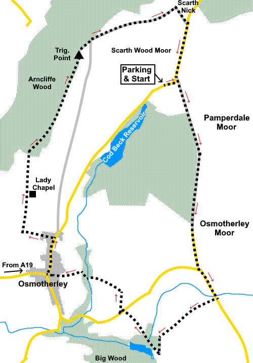
walk as a convenient stopping point, the route begins at a car park close to
Cod Beck Reservoir at SE 470993. Most easily described from the A19, head
into Osmotherley then at the ‘T’ junction turn left (North) along North
End. The car park is a further one and three quarter miles along on the
right. It is the second of two car parks, after passing the reservoir. Start: Turn right out of the car park (SE 470993) and after a couple of hundred yards, turn right over a footbridge and follow the broad track. This is shown on the OS map as High Lane.
Eventually, it becomes a tarmac lane before joining a road at SE 474973. Turn left along it Follow the road for a quarter of a mile until it crosses a small stream then turn right following a public footpath fingerpost. Follow the track as it descends to a ‘T’ junction with another track in Oak Dale (SE 469964). Turn right here.
Arrive at a road, opposite the very pretty garden of a house called Finklegates (SE 465968). Turn left along the road and at the end of the property, turn right along a broad track, following a fingerpost for “Cleveland Way” and “Osmotherley 1 mile”, After about two hundred and fifty yards, turn left through a slit stile to follow the fingerpost for “Cleveland Way” (SE 465970).
Just before Whitehouse Farm, the path swings right (SE 464971), clearly signposted for “Cleveland Way”. Cross a broad track (SE 461972) and keep straight ahead over a bridge into the woods. The path bears right following a wooden fence and leads into Osmotherley.
Turn right up the street (North End) and look out for a large house on the left, at the edge of the village (Ruebury House). Turn left immediately after it following a fingerpost for “Scarth Nick”, “Cleveland Way” and “Lady Chapel 1½ miles”. After a quarter of a mile, turn right for Lady’s Chapel which is signposted (SE 453977). Immediately on the left is a good view across the Vale of Mowbray and Teeside with a topograph. As you walk along the track, there are various crosses marking the Stations of the Cross.
The track leads to a grassy clearing in which stand this pretty chapel. Continue across the clearing and there is an exit (SE 454982) which takes you through to the Cleveland Way. (Note this is at a higher level to the Cleveland Way as shown on the OS map but is signposted as the Cleveland Way and does drop down to the ‘official’ path.).
Turn right along the Cleveland Way and follow it as it descends to a broad track. Turn right and almost immediately, fork right (SE 454986). At SE 457990 meet another path. Keep left here. At SE 459995 pass a large radio station. Keep straight ahead over its drive. Shortly afterwards, you pass the trig. point which is over the wall in a field (SE 460997).
Continue following the Cleveland Way across Scarth Wood Moor where it has been paved. On reaching a three way fingerpost (NZ 471003), turn right to follow the Public Bridleway sign; leaving the Cleveland Way.
On reaching the road, turn right to follow it back to the car park. There is a brief off road footpath which follows the road on the right. If you need to buy any hiking equipment/clothing before your trip see the Hiking Store All information on this site is given in good faith and no liability is accepted in respect of any damage, loss or injury which might result from acting on it.
| | |||||||||||||||||

.jpg)
.jpg)
.jpg)
%20Bridge%20crossed%20just%20after%20the%20car%20park.jpg)
%20Moorland%20track%20looking%20back%20towards%20the%20road.jpg)
%20Distant%20view%20to%20Vale%20of%20Morbray.jpg)
%20View%20after%20leaving%20the%20road.jpg)
%20Bluebells%20in%20Oakdale.jpg)
%20More%20bluebells%20in%20Oak%20Dale.jpg)
%20Turn%20off%20track.jpg)
%20Footpath%20into%20Osmotherley.jpg)
%20Panorama%20and%20topograph%20at%20start%20of%20track%20to%20Lady%20Chhapel.jpg)
%20View%20on%20way%20to%20Lady%20Chapel.jpg)
%20Lady%20Chapel.jpg)
%20Radio%20station.jpg)
%20View%20along%20the%20NW%20edge%20of%20NY%20Moors.jpg)
%20View%20to%20NY%20Moors.jpg)
%20Lyke%20Wake%20Walk%20signpost.jpg)
%20View%20at%20Scarth%20Nick.jpg)