
|
|
|
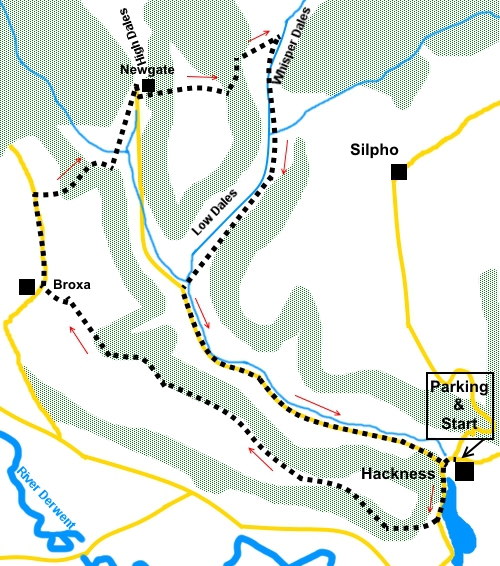
To view route as a dynamic Ordnance Survey map click here. Introduction: This walk from Hackness is a world away from the hurly burly and kiss-me-quick atmosphere of Scarborough which is only some 4/5 miles away. There was hardly anyone else in evidence when I did the walk. The route provides pleasant views over the valley of the River Derwent before dropping down to High Dales, Low Dales and the delightfully named Whisper Dales, where indeed you do feel a whisper is appropriate. Not a sound was to be heard, other than the chirping of our feathered friends. The walk starts from the tiny “estate” village of Hackness, which has Crossdales Beck running along by the road. The village boasts Hackness Hall, a Grade I listed building dating from 1790. It has extensive grounds but is private. The walk is generally straightforward but there is quite a short steep climb through trees between Low Dales and Whisper Dales, although it may not feel short at the time! It is worth it to experience the tranquillity of Whisper Dales. For this I include an amber traffic light. The walk starts from roadside parking close to the turn off for Silpho, opposite the school and St Peter’s Church. If, by any chance, the parking there is full, there is a car park about half a mile up the road to Sylpho. To get to Hackness, turn west off the A171 Scalby Road on the outskirts of Scarborough, on to Hackness Road. “Hackness 3 miles” is signposted. Simply follow the signs to the village. Start: With your back to St. Peter’s Church (SE 969906), turn left along the road and follow it round the bend. Turn right up a broad track, indicated by an old style metal footpath marker (SE 968904).
When the track divides, go right. The path climbs and after going through a five bar gate, you enter a large open field (SE 963904). Follow the left hand boundary initially, before gradually moving to the right to meet a gate at the end of the field. Go through the gateway and bear right to the right hand corner of the field. Cross the stile (note you may not see the stile until you are up to it). Follow the right hand boundary of the field beyond, alongside the trees.
Continue to follow the edge of the trees, ignoring a path over a stile into the trees. The route is obvious marked by stiles and yellow arrows. At the end of the trees, follow the right hand boundary of the field as it curves round to a stile by a gate. Cross and continue straight ahead past Broxa farmhouse, to the road (SE 946916). Turn right. This is a little used dead end road and looked more like a farm track, although it appears as a road on the map. There are good views to the left, over the valley of the River Derwent.
Walk along the road for just over a quarter of a mile and turn right by an old style metal footpath sign (SE 946921). The stile at the far side of the field is visible. This was a cropped field in which case single file please, to minimise damage. Cross the stile at the far side and follow the direction arrow left and down into the trees. At the end of the trees, the path turned right along the boundary.
Look out for a stile on the left and cross the field beyond to a stile in the opposite right corner (SE 952902). In the field beyond, follow the right hand boundary to a gate. Cross the stile and about fifty yards further on, cross another on the right. Turn right by the cottage and after going through a walkers Gate, turn left SE 951926). This is a very steep banking and the path is not clear. Keep as straight a line as you can and you should arrive at an old forestry track. Turn left along this and look out for a yellow arrow on a tree on the right indicating the onward route. The path enters a field at SE 954936. Follow the right hand boundary, then the clear track down the right hand side of the trees. After crossing a stile at the end of the track, there is a three way fingerpost. Follow the direction for Whisperdales. Note that it is important to follow the direction of the finger all the way across the field and not get drawn to the bigger track bearing left. At the far side of the field, the route continues, descending through the trees. At a banking, it turns right. There is a yellow arrow a few yards further on. The path opens into a field. Head for a point about half way along the far side where you join the track along Whisperdale (SE 959929). Turn right. When the main track looks to curve left, do not go with it but keep straight ahead following the course of the beck.
You arrive at two fords close together, at Lowdales Farm, where footbridges have been provided. Turn left along the road (SE 954916), ignoring a right turn for Highdales. Please note that further along the road is another ford (SE 955912). This was shallow at the time of my visit so was easy to paddle through. After heavy rain however, it would be advisable to take the path through the fields next to the road from Lowdales Farm. This culminates in a footbridge over this third ford. The footbridge would not be accessible if the ford was impassable. I noticed the depth measure next to the ford pessimistically went to six feet. In this extreme event no passage would be possible, as the footbridge would be under water! Continue along the road back to Hackness. If you need to buy any hiking equipment/clothing before your trip see the Hiking Store All information on this site is given in good faith and no liability is accepted in respect of any damage, loss or injury which might result from acting on it.
| | |||||||||||||||

.jpg)
.jpg)
.jpg)
%20St%20Peter's%20Church%20Hackness.jpg)
%20View%20over%20Low%20Dales.jpg)
%20View%20over%20the%20Derwent%20Valley.jpg)
%20Panorama%20of%20High%20Dales.jpg)
%20Autumn%20colours%20in%20High%20Dales.jpg)
%20Whisper%20Dales.jpg)
%20looking%20back%20along%20Whisper%20Dales.jpg)