
|
|
|
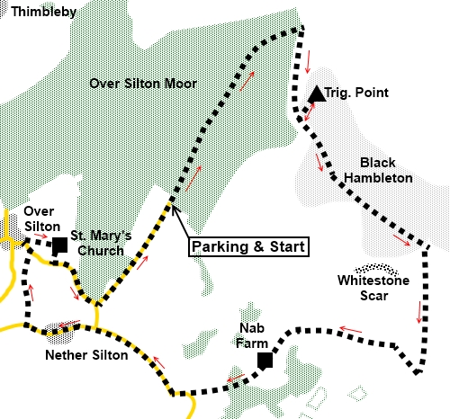
To view route as a dynamic Ordnance Survey map click here. Introduction: The walk starts through the Silton Forest, a Forestry Commission wood. Although this is mainly coniferous woodland, there were a fair number of deciduous trees along the start of the walk, which I imagine would provide an attractive autumn display. I was a little early. Black Hambleton is a plateau on the western edge of the North York Moors, rising to 1309ft (399 metres), where there is a trig. point. It is part of a larger plateau with Arden Great Moor. The Cleveland Way runs along its edge and indeed this walk follows part of it, the course of an ancient Drove Road. The hill is covered in heather which will make a great display in August. I did the walk in October and witnessed controlled but quite dramatic heather burning (see photo). The autumnal shades of brown were stunning. Along Black Hambleton, there are superb views to the south-west over the Vales of York and Mowbray and on a clear day, you will see the hills of the Yorkshire Dales and the Pennines. The walk passes through Nether Silton, an attractive village with a large green, church and pub, then on to Over Silton, where there is the intriguing St. Mary’s Church. This is not in the village itself but about a quarter of a mile away in the middle of a field, with no access other than the field footpaths. It is a combination of structures built between the 12th and 15th centuries. Because of its location, it has no electricity and services are held by candlelight. It is Grade II listed. Quite why the church was built in this location is a puzzle. Perhaps there were dwellings nearby at one time and the village has contracted away from the church as it depopulated. Maybe it was so the graveyard did not pollute watercourses! We may never know! The walk starts from Silton Forest car park. To get there, turn south east, off the A19, signposted for Over Silton. This is between the A168 and A684 turn offs to Northallerton. Please note if approaching from the south, you have a somewhat hair raising turn across the dual carriageways! Once off the A19, continue through the village without turning off for a further half mile or so. As the road bends right, turn left along the road marked as a cul de sac. When the tarmac runs out, you have reached the car park. Start: From the car park, exit the entrance and turn left, along a broad track, effectively continuing the line on which you approached in the car. You will pass an unusual signpost supplied by the Royal Bank of Scotland to commemorate the creation of the National Cycle Network.
Follow the track for just over a mile as it climbs steadily but after it levels out, look out for a public bridleway fingerpost on the right and turn off here (SE 476951).
Arrive at a gate where you join a broad stony track and turn right.
This track again climbs and as is about to level out, there is a large stone cairn on the left. Take the path alongside it to the trig. point (SE 479944).
Retrace your steps to the cairn and turn left.
Meet another broad track, where there is a two way fingerpost for the Cleveland Way. Turn right (SE 491932).
Pass another junction but continue straight ahead, Continue until you reach a gate in the wall on the right, marked with a yellow arrow and turn right here (SE 490919). It can be identified by a return in the wall ahead, with a post at the end of the return. Once through the gate, follow the wall on the left. Drop down into a little valley. As you descend, above you to the right, is Whitestone Scar. In the valley bottom, go through a gateway and up the hill at the other side.
Arrive at Nab Farm. Go through the farmyard and along the farm access track, straight ahead. This leads down to the road, where you turn right (SE 469917). Continue to Nether Silton village, passing the church and the pub. As you leave the village, where the road bends left, turn off to the right, following a public bridleway fingerpost.
At Greystone Farm, the path passes between the farmhouse and a barn, over a little stone stile. Follow the footpath as it curves right at first, then bends left to a stream and rises to a gate. Continue to the exit on to the road and turn left. Turn right over a stile by a notice board for St Mary’s Church, following a public footpath sign. If you wanted to see the village first, continue along the road for a hundred yards or so and turn right, although there is little to see here, other that what must have been a tiny school, now a house.
The route across the field to the church is obvious and it is worth a peek inside.
Exit the church gate and turn left to the road. Follow it to the junction and turn left (SE 460926). This returns you to the car park. If you need to buy any hiking equipment/clothing before your trip see the Hiking Store All information on this site is given in good faith and no liability is accepted in respect of any damage, loss or injury which might result from acting on it.
| | |||||||||||||||||

.jpg)
.jpg)
.jpg)
%20Start%20of%20the%20track%20through%20the%20forest.jpg)
%20Unusual%20signpost.jpg)
%20Black%20Hambleton.jpg)
View%20across%20Over%20Silton%20Moor.jpg)
%20Cairn%20Marking%20turn%20to%20trig.%20point.jpg)
%20Black%20Hambleton%20Trig.%20Point.jpg)
%20Views%20across%20the%20Vales%20of%20York%20and%20Mowbray.jpg)
%20Heather%20burning%20at%20Black%20Hambleton.jpg)
%20Autumn%20Colours%20at%20Black%20Hambleton.jpg)
%20Whitestone%20Scar%20and%20Black%20Hambleton.jpg)
%20All%20Saints%20Church%20Nether%20Silton.jpg)
%20village%20green%20Nether%20Silton.jpg)
%20Old%20school,%20Over%20Silton.jpg)
%20St%20marys%20Church%20Over%20Silton.jpg)
%20Interior%20of%20St%20Marys%20Church%20Over%20Silton.jpg)