
|
|
|
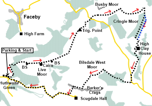
To view route as a dynamic Ordnance Survey map click here. Introduction: This is one of the most delightful walks in the North York Moors, providing lovely views for most of its length. I have called it the Bilsdale West Moor Circuit simply because this moor sits in the middle of the circuit but the route covers a number of other moors too. It will be a spectacular sight when the heather is in bloom. A limited number of photos on my Scugdale walk will give you an impression. The first third or so of the walk follows the Cleveland Way along the northern edge of the North York Moors to the top of Carlton Bank and on to a spectacular viewpoint at Cringle Moor, the third highest hill in the North York Moors, with a handy seat for lunch. All along this section there are great views to Teeside. The route then heads to the end of Raisdale before moving on to Scugdale, across open moorland and the impressive Barker’s Crags, popular with climbers. There is a final easy road return to the start along tranquil Scugdale. Scugdale was not so tranquil back in 2012 when I originally set off to complete this circuit because I had a bad fall on the edge of the moor, after only a mile or two and tore ligaments in my knee. I had vowed to do the walk again one day but having finally got round to it, rather than tempt fate, decided to do it in reverse order, this time starting at the tiny hamlet of Huthwaite Green. To get there, turn south east off the A172 for Swainby. Head along the main street and after leaving the edge of the village, turn left on to Scugdale Road. Keep straight ahead on this road. Just after a row of cottages on the left at Huthwaite Green, opposite a road junction is a small parking area from where the Cleveland Way starts. Start: Out of the parking area (NZ 493007), follow the Cleveland Way fingerpost for “Carlton bank 2¾ miles Public Bridleway”. As you reach the trees, there is a choice of gates. Keep straight ahead following the Acorn sign, up the cobbled path.
At the next gate, a sign tells you are “Welcome to the Raisdale Estate”, as you enter open moorland.
Stay on the main, obvious path coming to a boundary stone at NZ 500013. The next waymark, about a third of a mile further on, is a Bronze Age burial mound at NZ 505013. A nearby plaque tells you this dates from 2000BC and it is a Scheduled Ancient Monument.
Pass another boundary stone at NZ 509014.
Continue following the clear path until you reach the trig. point (NZ 519026). Along side it is yet another boundary stone which also has an Ordnance Survey benchmark inscribed. These were used to indicate the point of measurement above sea level in the days before GPS satellites.
Beyond the trig. point, follow the path down Carlton Bank to the road.
Cross the road and continue to follow the Cleveland Way and straight through the grounds of the Lord’s Stones pub/café, campsite etc. At a three way fingerpost, a few hundred yards later, continue following the Cleveland Way, straight ahead, starting quite a steep climb. You arrive at a spectacularly situated seat, an ideal lunch stop with a fabulous view towards Middlesborough. A topograph helps identify landmarks (NZ 535034).
Continue to follow the Cleveland Way along the edge of the moor until you get to a three way fingerpost at a wall (NZ 544034). Here, leave the Cleveland Way by turning right to follow the public footpath fingerpost.
Follow the wall along. As it ends by some trees, it becomes a fence. I followed this along and continued on a clear wide track, between two lots of woodland. I have to own up at this point and say I was seduced by this track because the official footpath according to the OS map, follows the line of the wall for a further two hundred yards or so, before turning right into the trees (NZ 544031) and exiting in the far left hand corner of them. I have indicated the correct route by the blue dotted path on the sketch map. I had gone beyond the point where I wanted to retrace my steps, and realising this route was parallel with the correct path, continued along the track, passing various “flying saucer” bird feeding stations, until I got to the end of the wood on the right. Here, on joining another wide track, I first turned left for a few yards, then right which put me back on the path I should have followed. Join another broad stony track at a bend and turn right. Follow this round the field and just after turning a left hand, right angled bend, go through a double stile arrangement on the right, marked with a yellow arrow. Keep to the right of a barn and cross a stile there, arriving at High Clay House. Turn left along its access road. At Hall Garth farm, by the pond, turn right along the broad track. Stay on this track as it curves left by the trees then on a bend, look out for another broad track on the right, descending into the trees (NZ 542015). Follow this through the trees and continue to follow it, as it runs along the right hand side of the little valley.
Join the road at NZ 539008 and turn left along it for about three hundred yards. As the road bends left, turn right at an old style iron footpath sign to Raisdale Mill House. Follow the drive through the yard and through a gate at the far side, then, keep right alongside the barn, to go up the right hand side of the stream. Keep on the path more or less parallel with the stream, until you meet a broad track. Turn left. Follow the track through the trees and as it bends sharply left, take the right fork on a lesser track to a five bar gate marked with yellow arrows. Go through the gate and bear left. Well trodden grass should indicate the way towards the right hand end of the pine trees. As you progress up the field, you will see a metal gate ahead. Go through this and a second metal gate. Turn left just before the small building. Go through another metal gate, then, turn left, climbing the hill. The path starts to curve right, as though going to the top of the moor but to the left is another path which is the one to follow. It should be noted that the paths form here to Barker’s Crags can be a little hard to follow through the heather. As you climb, you should spot a marker post on the horizon. Head for this. From this post, bear left to the fingerpost you should see on the next horizon. Here you come to a junction of paths by Brian’s Pond (NZ 523007). Turn right very briefly, for no more than a few feet, before turning left to follow a bridleway. This should have been marked with a fingerpost but this was lying on the ground at the time!
When the path divides, keep to the right hand fork. You are heading towards a small but reasonably prominent hill on the horizon.
Arrive at some rock outcrops with a good view over Scugdale (NZ 521004). Turn right to follow the top of the escarpment for about a quarter of a mile. Cross a crude stile over a dilapidated wall and turn immediately left, to descend through the crags to the road. Turn right along the road back to the car. If you need to buy any hiking equipment/clothing before your trip see the Hiking Store All information on this site is given in good faith and no liability is accepted in respect of any damage, loss or injury which might result from acting on it.
| | |||||||||||||||||

.jpg)
.jpg)
.jpg)
%20Panorama%20ascending%20Live%20Moor.jpg)
%20View%20to%20Roseberry%20Topping%20and%20Whorl%20Hill.jpg)
%20View%20to%20Roseberry%20Topping%20at%20Great%20Bonny%20cliff.jpg)
%20Cairn%20above%20Carlton%20Bank.jpg)
%20Boundary%20Stone%20Above%20Carlton%20Bank.jpg)
%20Trig%20Point%20at%20Carlton%20Bank.jpg)
%20Descanding%20to%20the%20road%20at%20Carlton%20Bank.jpg)
%20The%20Alec%20Falconer%20seat%20on%20Cringle%20Moor.jpg)
%20View%20from%20the%20Alec%20Falconer%20seat.jpg)
%20View%20along%20the%20edge%20of%20Cringle%20Moor.jpg)
%20View%20over%20the%20valley%20to%20Cold%20Moor.jpg)
%20Brians%20Pool%20on%20Bilsdale%20West%20Moor.jpg)
%20View%20over%20Scugdale.jpg)
%20Barkers%20Crags.jpg)