
|
|
|
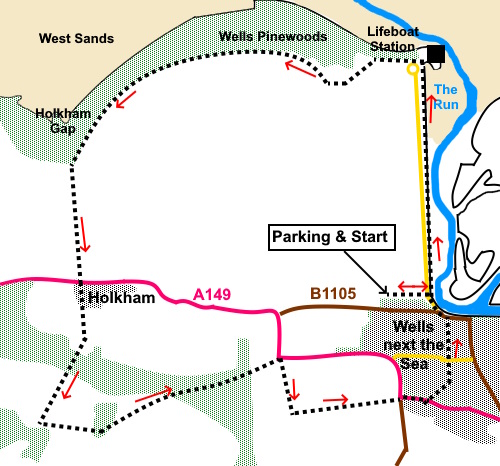
To view route as a dynamic Ordnance Survey map click here. Introduction: This is a very easy, level walk from Wells next the Sea. It follows a pleasant section of the Peddars Way and Coast Path through Wells Pine Woods before returning via the grounds of Holkham Hall. There is no charge for just walking through the grounds. Wells sits pretty much in the centre of the Norfolk Coast Area of Outstanding Natural Beauty. It gets its name due to the many chalk springs in the town. It was a major port but its importance declined following the introduction of the railways. Its quayside and former granary building are evidence of its past. It has some quaint streets, pleasant shops and some vast beach and marsh areas. The walks starts along the course of a channel called The Run which gives you the chance to see the beach/marsh areas. It also has some decent pubs! The Wells Pinewoods were planted between 1853 and 1890 to stabilise the dunes and stop sand drifting on to crops, an area now a grazing marsh. Abraham’s Bosom is a lake where you have a good chance of seeing a range of water birds. Holkham Hall is an 18th Century Palladian style country house constructed for the 1st Earl of Leicester. It is still the family home, open to the public on limited days of the week. There is a charge but it is free to walk through the grounds. The grounds are fairly typical of this sort of house with large grassed areas, trees and lake. One disappointment is that if you look at the map, you will see that a long drive on the estate leads to Golden Gates. I had intended to take this route back to Wells but the gates are out of bounds and locked, so don’t try! The walk starts at a pay and display car park to the west of the harbour area. To get there, turn east off the A149, at a sharp bend to the west of the town, on to the B1105. It is signposted with a brown tourist sign to Pinewoods caravan park and a road sign for “Wells Quay ¾ mile”. The car park entrance is in just under half a mile on the left. Start: Leave the car park (TF 413939) via a footpath at the opposite end to where you drove in. Cross the road and turn left to follow the Coastal Footpath fingerpost and take the path along the top of the sea defences.
Once you get to the beach car park, after passing a small marina, it is worth going to at least have a look at the beach but to follow the path I used, walk across the car park in front of the café and follow the fingerpost at the edge of the trees for “Norfolk Coast Path”.
Follow the path to Holkam Gap (TF 891450), a popular spot with its large, green, round café (The Lookout) There is a viewpoint close by with seats, if you follow the path towards the sea, (though it was too cold and windy for me to spend much time there!), you get a good view over towards the sand dunes. I believe there is a fantastic beach beyond the dunes but it is quite a way out.
The route continues through the car park and along its access road to the main A149. Cross straight over to walk up the elegant road to the grounds of Holkam Park. Pass the almshouses and go through the impressive gateway. Continue along the main drive.
When you get to a main junction where right is to the car park, turn left, following a fingerpost for “Wells 2½ miles” (TF 889430). At a fork, bear left for Wells. NB. Do not continue straight ahead. I had anticipated returning to Wells via Golden Gates and Gallows hill but the exit gates on to the B1105 are locked. Follow the obvious route, eventually passing a lodge house. The pedestrian gate is to the left. On reaching the A149 at a corner, you could simply continue straight ahead into Wells but for a more interesting return, I turned right here to follow a public footpath fingerpost. Continue as it curves left round a building. As you get to the end of the first field on the right, turn left following a public bridleway fingerpost (TF 906431).
At the main road, turn left and immediately right along Burnt Street (the A149). After about two hundred yards, turn left along an alley. This leads into Plummers Hill. Turn left. You will arrive at Buttlands Park, a large green “square” with some elegant houses round it. There are also a couple of good pubs if you are in need of refreshment. Follow either of the roads along the long sides of the grassy area and continue in the same direction to reach the seafront. You will then be able to work out where you are in relation to the car park. You will most likely need to turn left. If you need to buy any hiking equipment/clothing before your trip see the Hiking Store All information on this site is given in good faith and no liability is accepted in respect of any damage, loss or injury which might result from acting on it.
| | |||||||||||||||||

.jpg)
.jpg)
.jpg)
%20Boats%20moored%20at%20Wells%20next%20the%20Sea.jpg)
%20The%20old%20granery.jpg)
%20Footpath%20along%20the%20sea%20defences.jpg)
%20Looking%20over%20the%20run.jpg)
%20Marina.jpg)
%20Wells%20beach.jpg)
%20Preparing%20to%20retrieve%20lifeboat.jpg)
%20Abraham's%20Bosom.jpg)
%20Path%20through%20the%20pinewoods.jpg)
%20Holkham%20Gap.jpg)
%20Entrance%20gate%20and%20alms%20houses%20at%20Holkham%20Hall.jpg)
%20Final%20section%20of%20footpath.jpg)
%20At%20natures%20mercy.jpg)