|
Lanzarote
Walk - Montaña Corona – Costa Teguise
|
Starting
point:
Costa
Teguise - Beatriz Hotel
|
Map
I
have found this to be the best map for both walking routes and driving, from
Discovery Walking Guides Ltd
Lanzarote
Tour and Trail Map 1:40,000 scale

| |
Distance: 4
miles
| |
Traffic light rating:


(For explanation see My
Walks page)
More great Lanzarote
Walks
|

Click
the PDF logo above to give a printable version of this walk without the
photos.
|
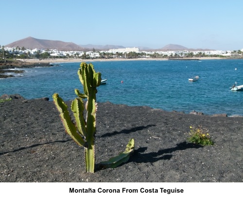
Introduction: This Montaña
Corona sits inland from Costa Teguise, as opposed to another with the same
name in the north of Lanzarote. It juts out from an arid plain, which means
there are uninterrupted 360° views from the top. These look out to sea over
Costa Teguise to the east. It is clearly the remains of a volcanic cone, the
eastern side having collapsed long ago and provides a dramatic ridge walk.
Arid
as the plain is, you will see various plants clinging to life along the
route.
Navigation
is very straightforward as you can clearly see the ascent path as you
approach. However, the walk needs to be treated with respect. Although Montaña
Corona is only 761 ft high (232 metres), as I discovered, there can be a
huge difference in wind strength between a gentle breeze at sea level and
the summit. I think this might have been because the half volcanic crater
was acting like a funnel to concentrate the easterly wind and the gusting
effect made it difficult to remain standing at times. Additionally, the
summit ridge surface is extremely “lumpy” so you have to watch where you
put your feet. The drops either side of the ridge are quite steep and the
walk may not suit vertigo sufferers.
I
strongly recommend walking the route anti-clockwise, as I did, because the
ascent path is very slithery and I find it better to ascend than descend
this type of path. Also, by going this way, the descent path is very
straightforward. There are alternative paths down but this one was
recommended to me by a local I met at the summit and his advice was sound.
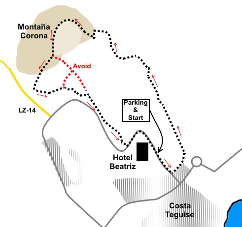
The
walk starts from outside the Beatriz Hotel where there is plenty of free
parking on the road. To get there, take the road LZ-14 which runs from the
LZ-1 to Costa Teguise. At a ‘T’ junction, turn left along Calle de
Atalya. Follow the road round a bend and the hotel is on the right.
If
you are staying in Costa Teguise itself, you can easily walk from there.
Start: With your back to the hotel, turn right along either the road
or a wide track which runs alongside the road or you could probably cross
open country to join the track mentioned below at #.
%20Hotel%20Beatriz%20and%20Montana%20Corona.jpg)
Opposite
a road junction, just before the buildings, turn left on to a track
indicated by a wooden post. Within a few yards, turn right along a track at
the rear of the buildings.
As
you get to the end of the buildings, where the track bends right, head off
left along a faintly visible track, which becomes more visible as you
progress. It joins a broader track at a ‘T’ junction, after crossing a
long, man-made ridge. Turn left.
%20Approaching%20Montana%20Corona.jpg)
You
now follow this track (see #
above)for about three quarters of a mile, passing a ruined building off to
the right, until after going round a distinctive right hand bend and passing
some dilapidate stone walls, you turn left following a narrower path towards
the right hand end of the mountain.
%20Flowers%20seen%20en%20route.jpg)
At
a ‘T’ junction, turn left.
At
the next fork in the path, go right and the route to the ascent path is
obvious.
You
will come to a little cross-roads. Go straight on but almost immediately
afterwards, at a fork, consider options. The path straight ahead is a climb
which zig-zags up the steepest part of hill. The right fork swings round in
a more gently climbing arc to join the same path higher up.
%20View%20along%20the%20ascent%20ridge%20to%20Costa%20Teguise.jpg)
Climb
to the top and follow the crater rim round to the summit.
%20Looking%20along%20summit%20ridge.jpg)
%20Montana%20de%20Saga.jpg)
%20View%20North.jpg)
There
is little to mark the summit but look down to the south-west and you can see
the better descent path recommended to me. It is not all that obvious for
the first hundred yards or so but you can see where it becomes obvious lower
down, with stones edging it. Avoid the other path which I have marked in red
on the sketch plan.
%20Panoramic%20shot%20along%20summit%20ridge.jpg)
%20View%20inland%20towards%20Teguise%20Old%20Town.jpg)
The
direction of the better path was almost straight on from the ridge behind
you and before it curves round and down to the red path. It is difficult to
describe but clear when you get there.
The
path is only a little slithery for a hundred yards or so, before you join
the better defined section. Follow it down to a ‘T’ junction and turn
left.
%20Looking%20back%20at%20summit%20during%20descent.jpg)
%20A%20small%20oasis.jpg)
Stay
on this path, ignoring any turns off until you reach another ‘T’
junction by a dilapidated stone wall. Turn right here, along the broader
track which follows the wall. The path also mostly follows in the same
direction as the road which you can see to the right so you could walk along
the pavement if you wanted.
Hotel
Beatriz comes into view quite dramatically. You join a well defined track.
It comes down to the road by a marker arrow then climbs to a promontory
before continuing so it seemed sensible to join the paved footpath here back
to the parking.
If you need to buy any
hiking equipment/clothing before your trip see the Hiking
Store
All information on this
site is given in good faith and no liability is accepted in respect of any
damage, loss or injury which might result from acting on it.
|


.jpg)
.jpg)
.jpg)