|
Waddington
Fell Walk
Starting point and OS Grid reference: 
Free
roadside car park on the B6478 close to Waddington Fell Quarry (SD 719481)
|
Ordnance Survey Map
OL41
– Forest of Bowland & Ribblesdale.
Buy this map from
List
of OS Maps
Note: If you use OS Maps on-line, you can download this route via this
link.
| |
Distance: 6
miles
|
Date of Walk: 27
May 2012
| |
Ascent:
Descent:
See Walking Time Calculator
|
922ft (281m)
922ft (281m)
| |
Traffic
light rating: 
(For explanation see
My Walks page)
| |


For advice on .gpx files see
My
Walks page
|

Click
the PDF logo above to give a printable version of this walk without the
photos.
|
To
view route as a dynamic Ordnance Survey map click here.
Introduction:
Waddington Fell is an area of high
moorland somewhat in “no man’s land” between the Forest of Bowland and
the Ribble Valley. I call the walk Waddington Fell because there is an
information board in the car park so headed but in reality, it meanders
across Bradford Fell and Grindleton Fell too. There is little more to say
about this walk other than it is a pleasant easy walk for two or three hours
with good views of the Ribble Valley and Pendle Hill.
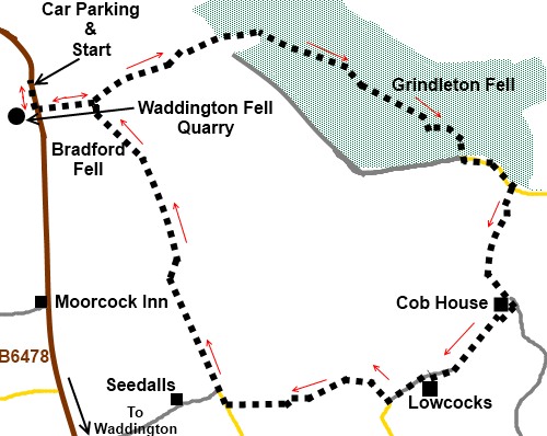
The walk starts at the car park just by the
cattle grid between Newton and Waddington on the B6478, by Waddington Fell
Quarry.
Start:
Leave the car park by turning left to walk along the road, over the cattle
grid, in the direction of Waddington.
Opposite the Waddington Fell Quarry entrance
take the footpath indicated by the public footpath fingerpost and follow the
obvious track across the moor. Note there is an aerial mast behind the
quarry which is visible for much of the walk and is a useful reference
point.
When you reach a five bar gate (SD 723480),
go through it and continue to follow the track ahead (bearing slightly left)
but note this spot, as the return route comes back here, alongside the wall
to your right.
%20The%20outward%20track%20across%20the%20moor.jpg)
When the track reaches a dilapidated wall, go
through the old gateposts, turning left and continue along the track with
the wall on your left. Follow it and the edge of the trees until it turns a
right angle. Just past here, go through the walkers’ gate on the left into
the woodland area (SD 734484). A faded footpath marker confirms the route.
%20Track%20through%20the%20Plantation.jpg)
Proceed through the trees on the obvious main
track, going straight through an old gateway where there seem to be tracks
going off left and right. Ignore these.
%20View%20from%20Plantation%20track.jpg)
When the main track forks, go right,
descending slightly.
Pass a stone house with a round upper floor
window (Pinewood - according to the OS map) and at the road, turn left (SD
747476).
The road bends to the right passing a public
footpath fingerpost on the left which you ignore. A further 200 yards or so
on the right, take the public bridleway indicated by the fingerpost, passing
under the power lines (SD 750474). There are a couple of sheltered spots for
a picnic, in the lee of walls along here, with nice views
%20Lunchtime%20view.jpg) .
.
Follow the bridleway as it descends gently
through a five bar gate in a line of trees and follow the wall on the right.
Ignore a stone stile in the wall. Go through another five bar gate and the
track bears left becoming a walled lane. The town of Clitheroe can be seen
in the distance.
At the end of the lane, through another gate,
pass Cob House and turn right over a stile just past the drive to the house
(SD 750474). Note that on the OS map, the path is shown as before the house
but signs confirm it has been diverted.
Follow the boundary of the Cob House property
to the end of the field where a yellow arrow confirms the way through a
small gate. Go over another stile and follow the right hand boundary wall of
the next field to a farm. Here, keep straight ahead passing to the left of
the barn. The way is marked by yellow arrows.
Go through the farmyard and a short distance
down the drive as it bends left, go over the wooden stile in the corner on
the right. Follow the right hand boundary wall and then hedge of the next
field. Towards the end of the field, the path goes into a sunken stretch but
is easier to stay on the left upper side due to vegetation further along.
Go through the gate at the end of the field
and cross the stream via the bridge. The path rises at the other side and
over a stile, keep to the left hand boundary of the field.
%20Ribblesdale%20View.jpg)
You arrive at Lowcocks Farm (SD 745462).
Here, walk past the farm to the right of the farmhouse then swing left
through the farmyard and follow the farm’s drive. At the road, turn right
on to the bridleway signed Bucks Farm.
At Bucks Farm, the OS map shows the path
going round the back of the farm but there seems to have been an unofficial
diversion and I was advised on site that most people just walk straight
through the farmyard – which seems acceptable to the residents.
Keep straight ahead once through the
farmyard, keeping the fence on your right. Turn right through the gate at
the end of the field then left through another into the woods.
The path descend to a stream and up the other
side. As the climb through the trees starts to level out, look out for a
gate on the right bearing a blue arrow. Cross the field diagonally, heading
for the gate you can see. Through this, continue the same line heading
towards the diagonally opposite corner of the next field also.
Cross the cattle grid and at the lane, turn
right (SD 731460). A sign informs that you are entering the drive for
Seedalls Farm. It bends left to the farm but continue straight ahead on the
stony bridleway. It passes a stone barn on the right.
%20Pendle%20hill.jpg)
Just past the barn are two gateways next to
each other, take the right hand one. Continue along the bridleway climbing
gently. It bends right, levels out, then bends to the left. Come to a gate
straight ahead. Go through this and follow the wall on the left. The
bridleway rises gently and as it bends sharply right, go through the gate
straight ahead, again following the wall on the left (SD 727473). The path
is now much fainter and is not shown on the OS map (this is Access land) but
just continue to follow the wall. In the distance to the right, there is the
plantation walked through earlier on during the walk.
Pass one gate on the left. The next is the
one noted on the outward journey and Waddington Fell quarry is clearly
visible. Retrace your steps to the car park.
If
you need to buy any hiking equipment/clothing before your trip see the Hiking
Store
All information on this
site is given in good faith and no liability is accepted in respect of any
damage, loss or injury which might result from acting on it.
|


.jpg)
.jpg)
.jpg)