
|
|
|
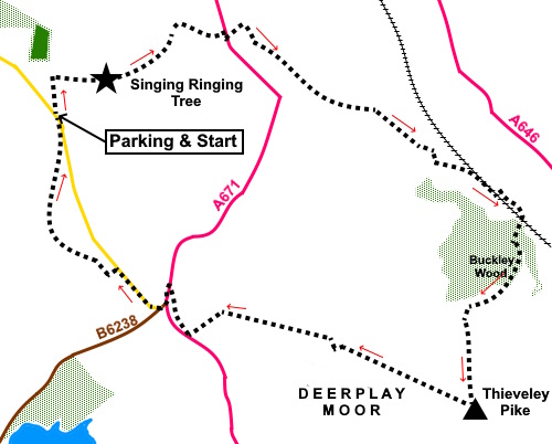
To view route as a dynamic Ordnance Survey map click here. Thieveley Pike is a hill in the South Pennines above Lancashire’s Calderdale, there being a river Calder in both Lancashire and Yorkshire, flowing in opposite directions from the watershed. The Pike is just to the west of the county border, the nearest point for the border being at SD 898 266 by the Burnley Road. A boundary stone is marked on the OS map. The Singing Ringing Tree is a tree shaped sculpture comprising a host of steel pipes welded together at a viewpoint overlooking the town of Burnley, from which there is a 360° view. It was completed in 2006 and the idea is that in the wind it produces various harmonic sounds. To be honest, I was a little disappointed in this because although there was quite a breeze blowing the ‘Tree’ was surprisingly (to me) quiet. It obviously needs a stronger wind blowing to give of its best, or perhaps I was expecting too much. Having said that, structurally it is impressive being some three metres tall. Alongside the ‘Tree’ is a topograph detailing many of the features you can see from there, including Pendle Hill, Ingleborough, Whernside and Pen y ghent to name but a few. The highest point on Deerplay Moor, Thieveley Pike is at an altitude of 449 meters (1,473 feet) and there is a trig point from which are great views. Unsurprisingly, it was the site of an ancient beacon. I started the walk seeing the ‘Tree’ first then descended into the valley, quite a steep route, before circling round to a similarly steep climb to the Pike. You get pretty views along what is known as the Cliviger Gorge, which is not identified on the map but is essentially the valley between Burnley and Todmorden, the most dramatic section being below Thieveley Pike. The steep climb is mercifully broken by a picnic table which makes a good lunch stop. The walk starts from a roadside parking area at Crown Point, about half way along Crown Point Road, which runs from the southern outskirts of Burnley off the A682 to the junction of the B6238 and A671. I recommend using sat. nav! Start: From the car park (SD 848288), take the clearly signposted path for the Singing Ringing Tree.
When you get to the ‘Tree’, continue past it through a kissing gate. Only ten to twenty yards beyond the gate look out for a faint track on the left (SD 851289). It is not easy to spot but as you look down the hill you will probably be able to make it out. You need to keep well left of a stone wall which goes down the hill. If you actually get as far as the dilapidated top section of that wall ahead of the kissing gate, you have missed the turn!
The path becomes clearer as you descend. Follow it down to a gate with a yellow marker by a small cottage. The gate was padlocked but cross the somewhat awkward stile by the gatepost and turn right in front of the cottage to follow its drive don to the A671 at Heyne Farm.
Turn
right along the road and after a few yards, turn left down some stone steps
to follow a public footpath fingerpost. At the
bottom of the steps, avoid the temptation to turn left or right along a
clear path but keep straight ahead downhill. This is an awkward section of
path, which might be difficult to spot. You reach a rickety bridge made of what look like railway sleepers (SD 859293) and contour round the small hill to the right of the fence. Look out for a gap in the fence on the left after a few yards and descend the steps to the drive. Turn right along the drive then right again after a few yards. Do not go on to the farm.
Continue
following this track, passing a farmhouse and a ruined building (SD 864287). Continue
past another farmhouse, emerging into a broad track. Turn left (SD 870284). After
about a hundred yards, as the track curves left, take the path straight
ahead. You will pass a blue marked post with PBW (Penning Bridle Way) on it
Shortly after this the path looks to fork but keep left. Pass under the railway line and turn right. You will reach another broad track by a three way fingerpost. Turn right to follow the track under the railway again.
You will
reach a farm gate (which was locked when I did the walk). Just before this,
turn right to follow the Burnley Way up some rough steps. Now begins the climb to the summit of Thieveley Pike. Not far after you come out of the trees, you should find a picnic table. Above the picnic table is a pile of stones, probably a collapsed building and beyond that is a walkers’ gate with a sign for Thieveley Pike.
Follow the path as it curves around the hill and then as it straightens up to head for the trig. Point at (SD 872271).
Relative
to your approach to the trig. point, turn right to follow the right hand
side of the fence for a hundred yards or so then turn left through a
walkers’ gate. Turn
right now with the fence on your right. Continue
to follow this route which will eventually curve left to meet the A671. You
could if you wished turn right along the road, there is a pavement but it is
a busy, fast road and not particularly pleasant to walk alongside. I
therefore turned right a yard or two before the road to follow a route which
I suspect has been created for those following the Pennine Bridleway to
avoid the road. The
bridleway still eventually rejoins the A671 where you turn left along the
footpath but at least it is not too far. At the
junction with the B6238, turn right and immediately right again on an
unsigned road (Crown Point Road). Pass a
small lay-by on the left and follow the road until the far end of a much
larger lay-by on the right. Here, turn left along a rough track (SD 852279).
Only a few yards along this track, turn right over a wooden stile. Follow
this path until it joins Crown Point Road at which point you will see the
car park area where you started. If you need to buy any hiking equipment/clothing before your trip see the Hiking Store All information on this site is given in good faith and no liability is accepted in respect of any damage, loss or injury which might result from acting on it.
| | |||||||||||||||||
.jpg)
.jpg)

.jpg)
.jpg)
.jpg)


%20View%20towards%20Pendle%20Hill%20near%20start%20of%20walk.jpg)
%20The%20Singing%20Ringing%20Tree.jpg)
%20Singing%20ringing%20tree%20(2).jpg)
%20View%20from%20the%20Singing%20Ringing%20Tree.jpg)
%20View%20North%20across%20the%20valley%20from%20the%20Singing%20Ringing%20Tree.jpg)
%20Descending%20Into%20The%20Valley.jpg)
%20Barn%20and%20windmills.jpg)
%20Junction%20of%20tracks%20at%20SD%20874282.jpg)
%20Railway%20arch.jpg)
%20View%20SE%20during%20climb%20up%20Thieveley%20Pike.jpg)
%20View%20SE%20from%20Thieveley%20Pike.jpg)
%20View%20West%20from%20Thieveley%20Pike.jpg)