
|
|
|
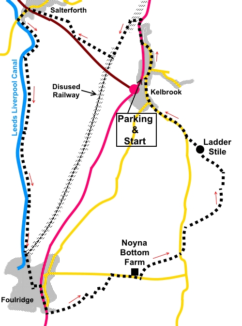
To view route as a dynamic Ordnance Survey map click here. Introduction: This varied walk from Kelbrook, close to the Yorkshire/Lancashire border, takes you on a pleasant, canal side walk to Foulridge, before climbing on to moor land and descending back to Kelbrook. Although I did not have a very clear atmosphere, it is obvious that there are some lovely views, on the second part of the walk especially. Kelbrook is a curious mixture of an attractive old village centre with some rather imposing, modern, industrial buildings on the outskirts. It was originally called Chelbrok and owned by William de Percy, a very powerful feudal baron. The Leeds/Liverpool Canal needs no introduction, the name says it all! It is the longest canal in Britain built as a single waterway at 127 miles. It took 46 years to complete. The mile long Foulridge Tunnel, which you see the entrance of, opened in 1796 after 6 years in the construction. There are no passing places in the tunnel, so use is controlled by traffic lights. The Foulridge name comes not from some unpleasant association but from the Anglo-Saxon words, fola – meaning foal and hyreg – meaning ridge. It is believed to have had associations with Oliver Cromwell and there is indeed a Cromwell Street. At one time, the town was famous for making hats. The walk starts at Kelbrook. To get there, turn east off the A56 at the village, opposite the Craven Heifer Inn. This takes you down the narrow Vicarage Road and over a narrow bridge to St. Mary’s church. There is on street parking in the area of the church. There is a tempting car park, belonging to the village hall but there are notices threatening clamping to non users of the hall, although I thought this was no longer legal! There is an excellent lunch opportunity at the Hare and Hounds pub in Foulridge. Start: Facing the front of the church, turn left and walk along Church Lane. When you get to the A56, turn right (there is a pavement). Walk along the A56 for no more than three hundred yards and just after the right hand curve in the road, look out on the left for a bridleway, indicated by a fingerpost for “Pennine Bridleway Barnoldswick 1¾ miles” (SD 902453). After a few yards, branch off right up some steps to climb to the old railway track and turn left along it, for a third of a mile. Look out for a footpath off to the right. This is not easy to spot amongst the trees/bushes (SD 898449). If you get as far as the road bridge, you have missed it by about a hundred and fifty yards! Follow the right hand boundary of the field beyond, to cross a stream via a footbridge. After the footbridge, follow the obvious path, soon crossing a broad track via two kissing gates and entering a recent housing development at Salterforth. Keep straight ahead on the path through the houses, arriving at the B6383 (SD 890434). Turn right briefly along the B6383, then quickly left by the war memorial, following the brown tourist sign for the Anchor Inn. Turn right at the Anchor Inn to join the canal towpath of the Leeds/Liverpool Canal and turn left along it. You now have a pleasant stroll along the canal’s well maintained towpath for just short of two miles, to Foulridge. You will know when you have got there when you reach Café Cargo. Just beyond this is the entrance to the Foulridge Tunnel.
Leave the towpath just after the café and walk up the street (Warehouse Lane). At the road junction, continue straight ahead, then follow the road as it curves left to join the A56. Turn right along the A56. Pass the Hare and Hounds pub (where I had a decent lunch and pint!) and continue until you are opposite the entrance to St. Michael and All Angels church. Turn left here, indicated by public footpath fingerposts. There are two paths here and you want the one heading left.
Just before Lower Broach Farm, the path has been diverted. Turn left following the yellow footpath arrow, then immediately right, following the right hand boundary of the field, until you reach a gated, stone stile. Go through this and turn left to follow the yellow arrows, towards the next farm. Follow the boundary wall on the left of the field. After going through a gateway, turn right. Go through another gate and turn left along the access track to the farm (SD 897422). After passing through the double gates, turn right along the land. There are good views to the right along here
Just past the buildings of Noyna Bottom Farm on the left, climb a high stone step stile to follow a public footpath fingerpost. At the first gateway, turn left without going through it and follow the wall, now on your right. As you progress up the field, it narrows and there is a stone step stile in the corner. Cross this, ignoring the kissing gate to the left. As you get to the end of the rocky outcrop of Noyna Hill, drop down the short bank to cross a stile. Continue in the same direction to cross a second stile, where an arrow indicates the route ahead. Continue in the direction of the farmhouse ahead, where the path skirts round the farm and is indicated with yellow arrows.
On arriving at the access track to the farm (Noyna End Farm), turn right and almost immediately left to follow a public footpath fingerpost (SD 910431). At the next farm, go through the farm gate, following the direction of the white arrow to the left of the house. Just before the drive levels out, cross the stile ahead over the fence. Turn right following the yellow arrow.
Cross another stile in the bottom right hand corner of the field, then head for the diagonally opposite corner of the next field and through the gate there. Go straight ahead and immediately left by the barn. Follow the stone wall for a few yards then turn right through a walkers’ gate. Follow the left hand wall to cross a stile into the lane. Continue over another stile almost immediately opposite to the farm you can see ahead. Cross the stile by the farm keeping to the farm’s right hand side. Cross another stile. At the corner of the building, turn left to follow a broad track. You may hear gunfire here but do not panic. It comes from the Kelbrook Shooting School, the wooden buildings you can see at the edge of the wood. As the track turns left into a field, keep straight ahead, following the wall on the left and the power lines. Cross a gated stile on to Roger Moor and turn left (SD 911436). This section can be a little boggy. You should see a ladder stile in the near distance. Cross this and turn left keeping more or less parallel with the wall. Cross another ladder stile (SD 909438) and follow the path downhill to meet the road (Cob Lane) through a walkers’ gate (SD 907440). Turn right back to Kelbrook. At the cross roads, turn right and right again at the next junction to return to the parking area. If you need to buy any hiking equipment/clothing before your trip see the Hiking Store All information on this site is given in good faith and no liability is accepted in respect of any damage, loss or injury which might result from acting on it.
| | |||||||||||||||||

.jpg)
.jpg)
.jpg)
%20Typical%20canal%20bridge.jpg)
%20View%20towards%20Kelbrook%20Moor%20from%20the%20Leeds%20Liverpool%20canal.jpg)
%20Barges%20on%20the%20Leeds%20Liverpool%20Canal.jpg)
%20Entrance%20to%20the%20Foulridge%20Tunnel.jpg)
%20St%20Michael%20and%20All%20Angels%20Church%20Foulridge.jpg)
%20View%20near%20Noyna%20Bottom%20Farm.jpg) .
.
%20Noyna%20Hill.jpg)
%20View%20back%20to%20Foulridge.jpg)
%20Random%20View.jpg)