|
Uldale
Fells Walk
Starting point and OS Grid reference:

Car
park at Over Water (NY 255354)
|
Ordnance Survey Map
OL4 - The
Lake District, NW Area.
Buy this map from
List
of OS Maps
Note: If you use OS Maps on-line, you can download this route via this
link.
| |
Distance: 6.7 miles
|
Date of Walk: 4 September 2011
| |
Ascent:
Descent:
See Walking Time Calculator
|
352m (1155ft)
353m (1153ft)
| |
Traffic
light rating: 

(For explanation see My
Walks page)
| |


For advice on .gpx files see
My Walks page
|

Click
the PDF logo above to give a printable version of this walk without the
photos.
|
To
view route as a dynamic Ordnance Survey map click here.
Introduction:
For many people, the northern
extremity of the Lake District stops at Skiddaw. This is a pity because the
northern hinterland of “The Lakes” provides some very pleasant walks.
This really easy walk provides some great views including the Solway Firth
and the Scottish hills beyond and a view of Skiddaw which many visitors to
“The Lakes” never see. There is an ancient extensive earthwork to
examine and an unusual statue. This is a little walked area compared to the
main Lake District areas and you may well meet no-one else.
There is some road walking
but only on very quiet roads where you will meet virtually no traffic. Also,
some of the footpaths do not appear as public footpaths on the OS map but
this is Open Access land and I can assure you the tracks are easy to follow.
The walk starts at the
small car park at Over Water. To get there, turn north east off the A591 at
the Castle Inn Hotel at Kilnhill signposted for Uldale, Ireby and Caldbeck.
After 2 miles, turn right signposted Overwater 1 mile. Follow this road past
Overwater itself then bear right
at a road sign for Orthwaite The
small car park (little more than a rough lay-by) is 100 yards on the left.
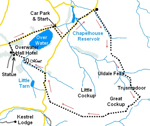
Start:
From the car park (NY 255354), turn left along the narrow road. At the
road junction, turn left in the direction of Caldbeck (indicated by the road
sign).
%20Over%20Water.jpg)
%20Looking%20across%20Chapelhouse%20Reservoir%20to%20Green%20How.jpg)
Walk along the road for
half a mile and lookout on the right for a finger post “Public Way
Greenhead 1½ miles and Cumbria
Way” (NY 266359). Go through the gate but instead of taking the direction
of the fingerpost, turn sharp right and cross the stream to take the obvious
broad track up the left hand side of the stream. Having started quite
obviously, the path becomes a little indistinct but just keep following the
line of the wall and it soon becomes clear again.
%20Track%20approaching%20Great%20Cockup.jpg)
After just over half a
mile, the stream turns abruptly left to its source high on the fells but you
carry straight on. Just over half a mile, you come to another stream (NY
275342) at the junction of two valleys, one to the left and the other
straight ahead. Cross the stream and take the track up the valley straight
ahead. This ascent is shown with the unusual name Trusmadoor on the OS map
and represents the only climb on the walk.
As you climb Trusmadoor,
behind you is a good view of the Solway Firth and the Scottish hills beyond.
The path crosses a small
and easily negotiated patch of scree and looking back you can just see the
end of Over Water. The path levels out beneath another patch of scree and
there is a stone cairn. Take the path to the right of this cairn. As you
turn the corner (NY 295335), the mass of Skiddaw is ahead of you.
%20Along%20side%20of%20Great%20Cockup%20and%20Skiddaw.jpg)
There is a steep path to
the right to ascend the brilliantly named Great Cockup! However, our route
continues along the hillside, following the line of the stream below. The
path contours round the hillside and you will see Bassentwaite Lake ahead.
The clarity of the path varies but if in doubt, just keep following the
contour level around the hill until it reappears.
%20Skiddaw.jpg)
You should soon see the
broad grassy track ahead of you which you are going to join, turning right.
At a fork, go left and at a crossroad of paths, go straight ahead.
You come to a small rocky
hill (Brockle Crag), a good vantage point and the path turns right just
before this and descends to the broad gravel farm track below (at a finger
post pointing back the way you have come for Burn Tod
2 miles). Turn right when you get to it.
Follow the gravel track
along passing a small defunct quarry on the right. At the road (NY 253337),
turn right and walk along the road until you reach the white painted
Orthwaite Farm. Just past this and before the next farm, turn left over the
stile (NY 253341) in the direction of the fingerpost for Over Water Cottages
1¼ miles.
Just before the trees and a
metal gate, take the right fork. Go over a stile and follow the footpath
diagonally across this field to the far corner. Cross a stile and two plank
bridge across the stream and turn left. You will see some straight mounds on
the right which are the remains of the Moat shown on the OS map (NY 247344).
This earthwork is larger than you first think and I inadvertently went
diagonally across it but you should walk down the left hand side of the
field and turn right round the furthest point of the earthworks. You head
for the left hand side of the small isolated stand of trees which is at the
furthest corner of the earthworks.
%20Statue.jpg)
Go through the double gates and straight ahead,
indicated by a yellow footpath arrow. Follow the right hand boundary and as
you get towards the end of the field, look out for the unusual statue in a
small fenced enclosure (NY 244346) – if anyone knows what this represents,
please advise. At the end of the field, go through the gate into the lane
and turn left.
On reaching the tarmac
drive to the Overwater Hotel, by an old mill dam sluce gate, turn right.
At the junction with the
road (NY 243350), turn right and walk along the road, past Over Water, until
you reach a right turn which is the location of the car park.
If you need to buy any
hiking equipment/clothing before your trip see the Hiking
Store
Before
venturing on to the Lake District fells, for your own safety, please check
the Fell
Top Conditions
All information on this
site is given in good faith and no liability is accepted in respect of any
damage, loss or injury which might result from acting on it.
|


.jpg)
.jpg)
.jpg)