|
Sharp
Edge and Blencathra
Starting point and OS Grid reference:

Rough
parking on lane leading out of Scales (NY 349272)
|
Ordnance Survey Map
OL5
The English Lakes North-Eastern Area.
Buy this map from
List
of OS Maps
Note: If you use OS Maps on-line, you can download this route via this
link.
| |
Distance: 7 Miles
|
Date of Walk: 16 June 2010
| |
Ascent:
Descent:
See Walking Time Calculator
|
842m (2763ft)
832m (2729ft)
| |
Traffic
light rating: 

(For explanation see My
Walks page)
| |


For advice on .gpx files see
My Walks page
|

Click
the PDF logo above to give a printable version of this walk without the
photos.
|
To
view route as a dynamic Ordnance Survey map click here.
Introduction:
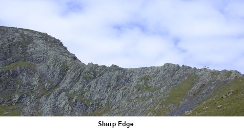
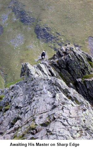
Sharp Edge is
definitely a walk with the “wow” factor. Although not a particularly
long walk, it is probably one of the most exhilarating you can do.
Unfortunately this also makes it potentially dangerous. Do not undertake
this walk in windy, icy or even wet conditions, nor if you have any
“vertigo” problems. It is not called Sharp Edge for nothing and in
places are precarious footholds above long drops which would be likely to
prove fatal if you fell. However, not to get things out of proportion, in
good conditions, with common sense and taking your time it is a truly great
walk. I have done it several times and I am still here to tell the tale.
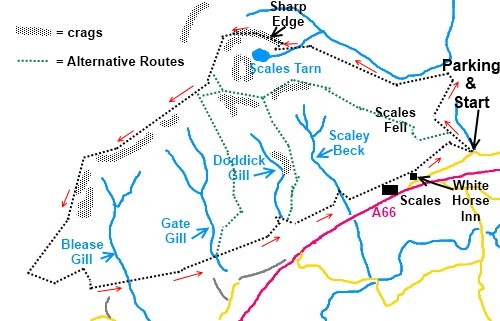
Start: The walk
begins at some rough parking behind Scales just off the A66. (NY 349272).
The A66 is a fast road and it is easy to miss the turn. Look out for the
road sign to Scales off to the north side of the A66 between Threlkeld and
the turn to the south for the A5091. In Scales (barely a hamlet) take the
lane at the eastern side of the White Horse pub. After just short of half a
mile, there is a sharp loop in the road and immediately after it is the
parking (NY 349272). There is not very much of it and at weekends/Bank
Holidays, you will need to get here early to secure a spot. The lane is
narrow and there is not really anywhere else to park.
To begin the
walk, head back just past the loop in the road and the footpath turns off to
the right. The path climbs steadily and at the top of a rise, look out for a
path heading across to join another (NY 347298) which follows the valley of
the River Glenderamackin on its south west side. Do not stay on the original
path and cross the river.
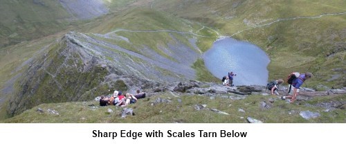
Follow the
obvious path parallel with the river for about three quarters of a mile.
Here is bears left to Scales Tarn (NY 338282) with Sharp Edge towering above
to the right. From Scales Tarn, the hard work begins. The approach to the
ridge is pretty obvious and you begin to climb it. To do it “properly”,
you should stay as close to the top as possible and there are spots where
you can stand with one foot either side of it. Then you really appreciate
the exposed nature of this place. Here and there are paths which avoid some
of the more exposed places, should you wish to use them.
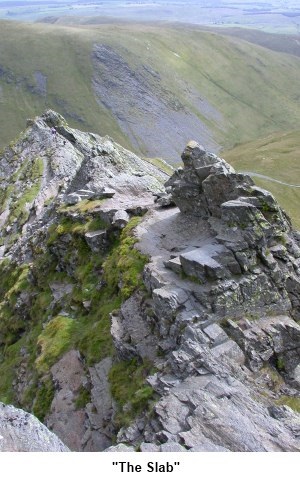
Fairly
unavoidable about half way along is “The Slab”. This is a flat section
of rock on the north side of the ridge, probably about four feet wide.
Because it is on the north side and in the shelter of rocks, it never gets
any sun. Even in otherwise good conditions it is often damp and greasy
looking. To aid the adrenaline, over its edge is a sheer drop and to crank
things up a bit more, it slopes very slightly towards that drop. Crossing
this always leaves me feeling a little uneasy. It is probably not as bad as
it always feels. Just take care and do not feel too ashamed to crawl across
it if that makes you feel more comfortable. I have seen many people do this.
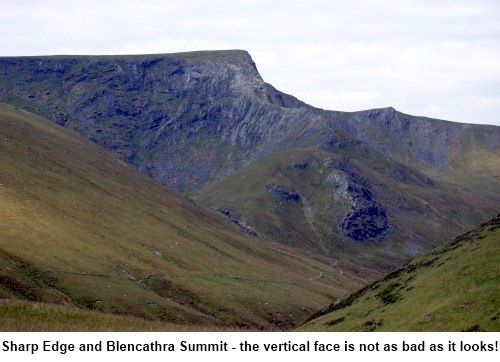
Beyond the
“The Slab”, eventually the ridge peters out at a fairly daunting rocky
face. This is by no means a vertical rock climb but it does require
use of hands as well as feet. If you have been using walking poles, this is
a good time to put them away until the descent.
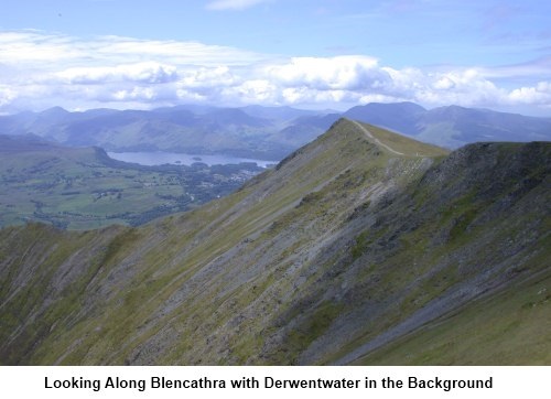
Once
you reach the top of the climb on to the top of Blencathra, take a deep
breath. Be sure to look back and appreciate the dramatic ridge you have
ascended.
Now
head south westerly to the summit cairn (NY 323277) and follow the edge to
Knowe Crags and Blease Fell (NY 311270) (if cloudy, set the compass bezel to
232°). This is the route for this walk but if you look at the OS map in
conjunction with the sketch map, there are a number of alternative routes
off Blencathra which can shorten the walk if you wish. They all lead down to
the path this route eventually joins.
From
Knowe Crag, a winding, knee testing path descends the fell until it meets
another path (NY 307261). Turn left here and head down until you reach a
wall which runs along the bottom of the fell (NY 313260).
The
route back to the car parking area now essentially just follows this wall
all the way back, passing to the north of Scales itself. Shortly afterwards,
it joins the path you originally took from the loop in the road and you turn
right.
If
you need to buy any hiking equipment/clothing before your trip see the Hiking
Store
Before
venturing on to the Lake District fells, for your own safety, please check
the Fell
Top Conditions
All information on this
site is given in good faith and no liability is accepted in respect of any
damage, loss or injury which might result from acting on it.
|


.jpg)
.jpg)
.jpg)