|
Place
Fell Walk
Starting point and OS Grid reference:

St
Patricks Church, Patterdale (NY 393162)
|
Ordnance Survey Map
OL5
- The English Lakes, North Eastern Area.
Buy this map from
List
of OS Maps
.Note: If you use OS Maps on-line, you can download this route via this
link.
| |
Distance: 7.35
miles
|
Date of Walk: 13 September 2009
| |
Ascent:
Descent:
See Walking Time Calculator
|
658m (2157ft)
658m (2157ft)
| |
Traffic
light rating: 

(For explanation see My
Walks page)
| |


For advice on .gpx files see
My Walks page
|

Click
the PDF logo above to give a printable version of this walk without the
photos.
|
To
view route as a dynamic Ordnance Survey map click here.
Introduction:
Many
people’s reaction to suggesting a walk on Place Fell tends to be ……..
where? It is an underrated fell no doubt because most of the people heading
down Patterdale where it starts have only Striding Edge
in their sights.
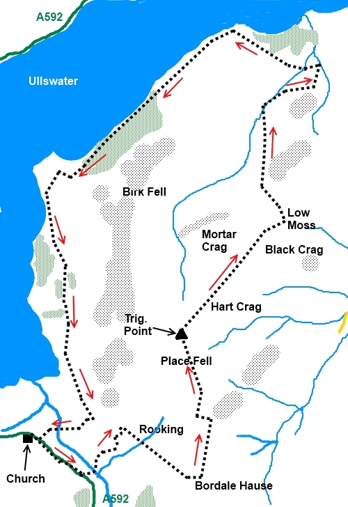
Place Fell heads off in the opposite direction and actually affords great
views of the entire Striding Edge/Helvellyn/Swirral Edge round – take
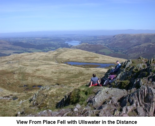
binoculars to get the best of it – and views of Ullswater. The walk is
relatively easy with no unpleasant surprises and a good walk for
beginners/children.
Parking can
be a problem in Patterdale at peak times. There is a large pay and display
car park at Glenridding and a free car park to the north eastern side of the
A592 opposite the Patterdale Hotel. For ease of reference, the walk starts
at St. Patrick’s Church (NY 393162).
Start: With the
church at your back, turn right and walk along the A592 footpath. Turn left
into a side road (NY 398158) and immediately over a bridge which crosses
Goldrill Beck and goes to the hamlet of Rooking. At the hamlet, bear left
and look out for a finger post to Boredale Hause which takes you to the
right along a clear track (NY 401162).
Continue
gently climbing along this track for almost half a mile then bear left for
the Hause. The Hause has lush green grass and you may see ponies grazing. A
left turn here (NY 407158) leads you on a steady climb to the trig point on
top of Place Fell (NY 406170).

There
is a curving path from here which leads to a rock called The Knight but it
is quite easy to get sidetracked on to a path which leads down to Birk Fell.
A more certain way is to head north east directly from the trig. point
gradually descending to Low Moss (NY 414179). Here the path divides
and you should take the left fork. At the next fork (NY 413185), go left
again. On reaching the broad track which follows the lakeshore (a little
higher than the lake) (NY 417192) turn left.
Follow
the lakeshore on the undulating path. A quarter of a mile after reaching the
end of the lake, turn right at Side Farm (NY 398163) and follow the track
back to the main road. Turn right and St Patrick’s Church is a few yards
further on, on the left.
If
you need to buy any hiking equipment/clothing before your trip see the Hiking
Store
Before
venturing on to the Lake District fells, for your own safety, please check
the Fell
Top Conditions
All information on this
site is given in good faith and no liability is accepted in respect of any
damage, loss or injury which might result from acting on it.
|


.jpg)
.jpg)
.jpg)