|
The
Old Man of Coniston and Wetherlam
Starting point and OS Grid reference:

Lane
from Coniston Village centre (SD 301978)
|
Ordnance Survey Map
Explorer
OL6 – The English Lakes – South-West Area.
Buy this map from
List
of OS Maps
Note: If you use OS Maps on-line, you can download this route via this
link.
| |
Distance: 7.6 miles
|
Date of Walk: 8 August 2012
| |
Ascent:
Descent:
See Walking Time Calculator
|
1075m (3526ft)
1074m (3525ft)
| |
Traffic
light rating: 

(For explanation see My
Walks page)
| |


For advice on .gpx files see
My Walks page
|

Click
the PDF logo above to give a printable version of this walk without the
photos.
|
To
view route as a dynamic Ordnance Survey map click here.
Introduction:
The Old Man of Coniston known also as
Coniston Old man or just “The Old Man” is essentially a massive pile of
slate. It is not surprising therefore that there is much evidence of slate
mining and quarrying to be seen on this walk, which adds another dimension
of interest.
The Old Man is the last major peak at 2634ft
(803 metres) as you head south out of the Lake District. Consequently from
its peak, there are good views not just of the other Lake District hills but
also the coast.
This walk up Coniston Old Man forms a
horseshoe with Swirl How 2631ft (802 metres) and Wetherlam 2502ft (762 metres), so you get three summits to bag!
Coniston Old Man is very popular with
walkers. The route to the top is clear and in fine weather is usually busy.
Wetherlam by contrast is very quiet and most walkers clearly do an ascent
and descent of the Old Man, ignoring Wetherlam. This is a pity because in
many ways, the views from Wetherlam are better (in my opinion).
Another contrast is that whilst the path up
Coniston Old Man is rocky and steep, the descent down Wetherlam is relatively
gentle and grassy. For that reason I recommend following this clockwise
route rather than the other way round.
The summit of the Old Man is marked by a
trig. point and a large cairn and plinth, constructed of slate.
This is a high peak with attendant risk of
low cloud making navigation difficult. Although the paths are pretty clear
and there are larger than average cairns to help, please take a map and
compass with you. A descent into the wrong valley could mean a very long
detour back to your car!
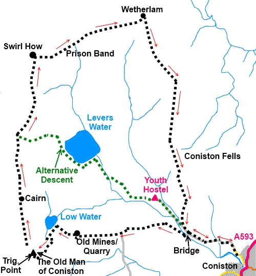
If you have to curtail the walk, there is an
“escape route” mid way between the first large cairn and Swirl How down
via Levers Water (indicated in green on the sketch map).
The walk starts from free parking in the lane
which runs north westerly, past the Black Bull Hotel, out of the centre of
Coniston village. Just continue past the yellow lines and park where you
can.
To get to Coniston, from the north, take the
A593 south west from Ambleside or from the south, go north east from
Broughton in Furness. The A5084 north from the A5092 is also an option.
Coniston has many refreshment opportunities
after your walk but your own sustenance is needed en route.
Start:
Walk along the lane heading away from Coniston village. The tarmac gives way
to a wide stony track (SD 300980). Follow this until you come to a bridge
(SD 294981) on the left. Cross this and turn immediately right on a narrow
but clear path which for a short while follows the course of the beck.
%20First%20View%20of%20the%20Mining%20Area.jpg)
%20Looking%20back%20to%20Coniston%20Water.jpg)
Turn right at a ‘T; junction of paths ( SD
284980). Ignore the next path off to
the right which wends its way round the bluff and stay on the main track
straight ahead.
As you get to the remains of the mine, with
spoil heaps and abandoned cables, the path goes up the left hand side.
Part way past the mines, you will notice an
old fallen pylon on the left. The path goes right here but it is worth a few
steps left to see the old mine entrance.
%20Remains%20of%20a%20bygone%20age.jpg)
%20More%20remains.jpg)
%20Old%20Haulage%20Motor.jpg)
On reaching Low Water (SD 276982), take the
path round its left hand side which gets a little steeper and simply follow
this to the summit.
%20Low%20Water.jpg)
From the trig point (SD 272978), follow the
ridge along curving slightly right. Avoid the path to the left which will
take you to Dow Crag.
%20Summit%20of%20Coniston%20Old%20Man.jpg)
%20Trig%20Point%20and%20Ridge%20to%20Swirl%20How.jpg)
(If you are in low cloud, the
general direction of the ridge from the trig point is between 336° and 350°
magnetic to the first stone cairn, then 357° for half a mile before
swinging slightly right to Swirl How. The path is clear on the ground.)
%20Dow%20Crag.jpg)
%20Looking%20Back%20along%20the%20ridge%20to%20Coniston%20Old%20man%20Summit.jpg)
At SD 271986,
you come to another large cairn which marks an unnamed summit (796 metres).
Continue along the ridge and the next large cairn marks Swirl How, where you
turn right for Wetherlam.
Along here are good views over to the Scafell
Range.
%20View%20over%20Seathwaite%20Tarn.jpg)
%20Levers%20Water.jpg)
%20Swirl%20How.jpg)
You descend the rough stony ridge of Prison
Band (NY277007) to a saddle, then rise to the top of Wetherlam
(NY 288001), marked by a stone cairn. Some of the best views of The
Langdales can be had along here.
%20Wetherlam.jpg)
%20Summit%20of%20Wetherlam.jpg)
%20View%20Across%20to%20the%20langdales.jpg)
The route from the top of Wetherlam is a
little indistinct at first but head just east of south towards a grassy
ridge. You soon see the path and Coniston Water helps you get your bearings.
The path passes to the left of a small tarn.
The path is mostly grassy and in places
becomes indistinct. Just descend steadily keeping in mind that ultimately,
you will be descending to the valley to the right (west) so do not wander
too far the other way. Eventually, you meet a clear track at a ‘T’
junction (SD 283990), turn right here.
%20View%20Across%20to%20Spoil%20Heaps.jpg)
The track comes into the valley bottom broad
track close to a row of cottages. Turn left and stay on this track back to
the car.
Before
venturing on to the Lake District fells, for your own safety, please check
the Fell
Top Conditions
If you need to buy any
hiking equipment/clothing before your trip see the Hiking
Store
All information on this
site is given in good faith and no liability is accepted in respect of any
damage, loss or injury which might result from acting on it.
|


.jpg)
.jpg)
.jpg)