|
Black
Combe
Starting point and OS Grid reference:

Lay-by
on the A5093 close to its junction with the A595 (SD 131823).
|
Ordnance Survey Map
OS
Explorer OL6 – The English Lakes - South Western Area.
Buy this map from
List
of OS Maps
Note: If you use OS Maps on-line, you can download this route via this
link.
| |
Distance: 8.8.
miles
|
Date of Walk: 30
May 2013
| |
Ascent:
Descent:
See Walking Time Calculator
|
754m (2473ft)
753m (2471ft)
| |
Traffic
light rating:
 
(For explanation see My
Walks page)
| |


For advice on .gpx files see
My Walks page
|

Click
the PDF logo above to give a printable version of this walk without the
photos.
|
To
view route as a dynamic Ordnance Survey
map click here.
Introduction:
A Black Combe walk is a useful walk
to have in your list of planned excursions for any trip to the Lake
District. “Useful” because set in the furthest, south west corner of the
National Park, a little remote from the main fells and close to the sea, it
can escape inclement weather affecting other fells, depending of course on
which way the weather is going.
Even many regular Lake District visitors have
never heard of Black Combe and the plus point therefore is that even at peak
times, you can have at least much of this walk to yourself.
At 1970ft (600m), Black Combe falls 30 ft
short of being a “mountain” but that is not to disrespect it because as
you start virtually at sea level, you have to climb every inch of it. In
terms of effort, it therefore requires as much input as some “proper
mountains” in the Lake District, where you can start at higher altitudes.
Moreover, the views from its summit north and south along the coast and
inland to the main Lake’s fells are superb. The Isle of Man and Scotland
are also clearly visible, at least on a clear day. The chances are that even
if poor weather obscures the views inland, you will still get good coastal
views.
As you approach from the east and south,
there is a dark coloured corrie (or combe) from which the hill gets its
name.
There is a multitude of tracks on Black
Combe. This is an “Open Access” area and people have obviously made
their own way, irrespective of the official Rights of Way (ROW) shown on the
OS map. A consequence is that not all the most obvious tracks on the ground
correspond with what the maps show as footpaths and in places, the
“official” ROW are virtually invisible. In describing this walk
therefore I have paid more attention to the following the most obvious
tracks/paths across the Open Access areas that actually exist, rather than
trying to slavishly follow the ROW.
The GPS route corresponds with the route
followed.
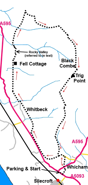
The walk starts from a large lay-by on the
A5093 yards from where it meets the A595, just outside the village of
Silecroft.
Start:
Turn right out of the lay-by SD 131823 in the direction of Millom along
the A5093 and after a few yards,
turn left at a fingerpost for Black Combe.
Black%20Combe%20from%20start%20point.jpg)
Head for the walkers’ gate in the middle of
the right hand side of the field and then turn left up the lane.
At the road, go straight across through
another walkers’ gate, then bear right to the opposite corners of the next
two fields. Exit on to a tarmac drive and turn left.
When the drive turns left to the house, go
straight ahead on the stony track. When it splits (SD 131829), the right
hand arm signposted for Black Combe, go left for the A595. This is in order
to create a circular walk. If you just want a simple “there and back”
walk, just follow the very clear path to the summit from this point.
Assuming you are following my circular route,
follow the path from the finger post and when you get to a bungalow, follow
its right hand boundary wall.
When the wall starts to descend, take the
path to the right. For about half a mile you now walk parallel with the
A595, no more than 10 yards from it in places but this is better than
walking along the road’s verges as it is fast and quite busy road.
%20Path%20alongside%20the%20A595.jpg)
Just as the path is about to join the road at
a fingerpost (SD122836), turn right to take the path gently climbing and
bearing left. At this point you are leaving the “official” ROW shown on
the map.
Go through a gate and turn left to follow the
path behind a small wood and on joining a broader track, turn left.
You come to a small valley with a stream at
the bottom and you may find your way obstructed by gorse (SD 122841). You
may have to head uphill slightly to find a passage through but then head
downhill across the stream to the wall. Turn right to follow the wall.
You come to a gate with barbed wire on its
top and a “no walkers” sign. Bear right to follow the wall. Do not go
through the gate.
You will soon find yourself on a much wider
track. Continue to follow the wall.
When the wall turns abruptly left, keep
straight ahead.
You arrive at another little valley with a
dam. Turn left, descend to the farm track and turn right (passing to the
left of Whitbeck Mill) (SD 118847), at which point you are back on an
“official” bridleway.
As you approach a disused quarry and the wall
goes off to the left, take the right hand fork, climbing on a grassy track.
Pass a more steeply climbing track on the right but ignore this and walk on
behind the old quarry.
Pass abandoned Fell Cottage at SD 116859.
You pass along a little valley with dramatic
rocks on the left. Climb out of the “rocky valley”, ignore the tracks
off to the right and bear left down towards the wall. Follow the wall along,
crossing two small valleys with streams (SD 116865 and SD 117871). At a
corner of the wall, as it bends left at 90°. Your track goes straight on.
%20Outcrops%20in%20rocky%20valley.jpg)
Just over ¼ mile on from the corner of the wall,
the path turns right (SD 120177). Continue on the clear track up to the
ridge where it bears right, to follow the ridge along.
%20View%20north%20towards%20Sellafield.jpg)
Stay on this track to a ‘T’ junction (SD
137857) and turn right to take you to the summit and the trig. point (SD
135855) in the centre of a crude shelter and enjoy the 360° view.
%20Black%20Combe%20trig%20point%20and%20view%20towards%20cental%20Lakes.jpg)
%20View%20SE%20towards%20Walney%20Island.jpg)
From the trig. point, head south west towards
the sea (243° magnetic). You will soon see a clear broad track descending
to the left which is your return route. Follow this down. When the track
splits at SD 130836, go left continuing to descend.
%20Return%20Leg.jpg)
%20View%20over%20Whicham%20Valley.jpg)
Keep descending the main track ignoring any
minor turns. You will soon catch sight of the lay-by where you started.
You meet your outward route at the A595
fingerpost. Turn left and retrace your steps to the car park.
If you need to buy any
hiking equipment/clothing before your trip see the Hiking
Store
Before
venturing on to the Lake District fells, for your own safety, please check
the Fell
Top Conditions
All information on this
site is given in good faith and no liability is accepted in respect of any
damage, loss or injury which might result from acting on it.
|


.jpg)
.jpg)
.jpg)