|
Uwchmynydd Circuit
|
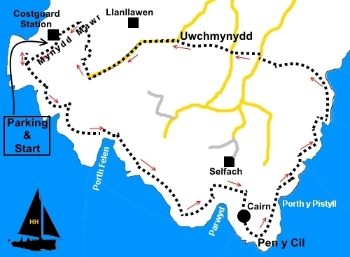
Starting
point and OS Grid reference:

Mynydd
Coastguard Hut (SH 140259) – free car park
|
Ordnance
Survey Map
OS
Explorer 253 - Lleyn Peninsula West.
Buy this map from
List of OS Maps
Note: If you use OS Maps on-line, you can download this route via this
link.
| |
Distance: 5.7 miles
|
Date of Walk: 11 May
2015
| |
Traffic light rating:

(For explanation see My
Walks page)
| |


For advice on .gpx files see
My
Walks page
|

Click
the PDF logo above to give a printable version of this walk without the
photos.
|
To
view route as a dynamic Ordnance Survey map click here.
Introduction:
I have called this the Uwchmynydd Circuit for want of a better name and
because it is a destination the road signs indicate. The walk explores the
far western tip of the Llŷn Peninsula from where there are views for
much of the walk across Bardsey Sound to Ynys Enlli (Bardsey Island).
Bardsey was a place of pilgrimage for Christians from the early days of
Christianity. The ruins of an Augustinian monastery remain. Day trips can be
arranged from Porth Meudwy, or from Pwllheli.
Much
of the coastline is unspoiled National Trust land which plummets straight
down to the sea. There are no beaches here.
The
walk starts from Mynydd Mawr, which means Big Mountain in Welsh. However it
is not so tall, only rising to about 500ft. At the top is a former
Coastguard lookout station until 1992. It was also part of a signal station
guarding against invasion during World War II, then housing around 70 RAF
personnel. It is now under the care of the National Trust.
Keep
a look out for choughs, birds with distinctive red bill and legs which
swoop, along the cliffs. You might also see oystercatchers, dolphins and
seals.
The
walk is very straightforward and utilises sections of the Welsh Coast Path,
which is not exactly where it appears on my (brand new) 2015 OS map but it
is well signposted and easy to follow.
Quarrying
was an important industry at one time but all is quiet now. You will pass
the remains of an old port during this walk but it is not accessible.
The
only refreshment opportunities en route are a couple of cafes close to the
end of the walk.
The
walk starts at the old Coastguard station at Mynydd Mawr. To get there, take
the B4413 to Aberdaron. In Aberdaron, turn right over the bridge for
“Whistling Sands”, then climb the hill. Continue to a junction and turn
left for Uwchmynydd. Just follow the road to its ultimate end. The last
section is a narrow concrete road climbing to the car park at the Coastguard
station.
Start: From
the car parking at Mynydd Mawr coastguard station (SH
140259), take the footpath to the left of the buildings along the
coast. The start of the path is a concrete section no doubt put down by the
military many years ago.
Follow
the path down until it reaches a ‘T’ junction of paths at the edge of
the coast. Our route turns left but it is worth a short diversion of no more
than 100 yards to the right first for the views along the coast (SH 156258).
%20View%20NE%20from%20SH%20156258.jpg)
Return
to the ‘T’ and continue along the coast path. The path follows the edge
of the coast as far as is practical. There are steep drops to the sea in
places.
%20Coast%20view%20with%20steep%20drop%20to%20sea.jpg)
%20Coast%20Path.jpg)
%20View%20to%20Bardsea%20Island.jpg)
There
is little more to add until after about one and a half miles, you come to a
National Trust sign for Bychestyn. An information board outlines steps being
taken to restore the heather which has been destroyed by burning over the
years and replaced by gorse.
%20Gorse%20bushes%20along%20the%20coast.jpg)
%20View%20back%20towards%20Mynydd%20Mawr.jpg)
%20Wild%20Flowers%20on%20old%20banking.jpg)
%20Looking%20along%20the%20coast%20to%20Aberdaron.jpg)
Beyond
the sign, keep to the left hand side of the next field. At first glance,
this is not particularly clear but there is a fingerpost by a gate in the
far left corner.
A
little further on, you come to the National Trust land of Pen-y-Cil where,
at SH 156243, there is a stone cairn. As you approach it, there is the cove
of Parwyd to the right, where the rock strata is revealed.
%20Stone%20cairn%20and%20view%20to%20Bardsey%20Island.jpg)
%20Rock%20strata%20st%20Parwyd.jpg)
Below
the cliffs at SH 160246 are the ruins of docks at Porth Pistyll. This was
built to take granite stone quarried at Graig
y Cwlwm, nearby. Work is believed to have ceased in the 1930s and the sea
has gradually eroded the port. It was a dangerous place to work as the men
had to use ropes and ladders to get down to the port!
%20Remains%20of%20the%20port%20at%20Porth%20Pistyll.jpg)
Just
beyond the ruined port, a footpath goes off to the left (SH 162249) but
ignore this and continue along the cliff top path.
At
SH 163255, descend some stone steps to the cove and slipway at Porth Meudwy.
Turn left at the bottom to follow the broad track up the valley.
%20Steps%20down%20to%20Porth%20Meudwy.jpg)
At
SH 159256, just as the track bends right, turn off it left over a footbridge
across a stream. It is easy to miss this turn.
A
stony path and then steps take you up to the caravan site. Go through the
site to the road and turn right.
After
50 yards or so, turn left off the road through a kissing gate following the
direction of a public footpath fingerpost.
The
footpath is a little unusual in that it is on top of a distinct banking.
Follow this to a road and turn right and almost immediately left on a broad
track. When you get to the gate of the property, branch off left through a
kissing gate.
Go
over a step stile and in the next field, head just to the right of a power
pole. The onward route through a kissing gate is clear.
Follow
the right hand boundary in the field after the kissing gate – the arrow on
the kissing gate I found a little misleading.
At
the farm, go through the double set of gates to join the farm drive and
follow it to the road where you turn left.
There
are a couple off footpaths marked on the map to the right which would save
some road walking but to be honest, I had my sights set on a pot of tea and
cream tea at the Ty Newydd farm café just along the road, so simply
followed the road back to the Coastguard Station, the same route taken by
car at the outset. The distance saved by using the footpaths would be small
and as the road is a dead end, there is little traffic.
If you need to buy any
hiking equipment/clothing before your trip see the Hiking
Store
All information on this
site is given in good faith and no liability is accepted in respect of any
damage, loss or injury which might result from acting on it.
|


.jpg)
.jpg)
.jpg)