|
Flamborough
Head
|
Starting
point and OS Grid reference:

Danes
Dyke – Pay and Display car park (TA 216695)
|
Ordnance
Survey Map
OS
Explorer 301 – Scarborough, Bridlington and Flamborough Head.
Buy this map from
List
of OS Maps
Note: If you use OS Maps on-line, you can download this route via this
link.
| |
Distance: 9.3
miles
|
Date of Walk: 1
April 2015
| |
Traffic light rating:

(For explanation see My
Walks page)
| |


For advice on .gpx files see
My
Walks page
|

Click
the PDF logo above to give a printable version of this walk without the
photos.
|
To
view route as a dynamic Ordnance Survey map click here.
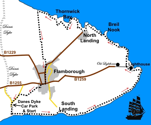
Introduction: This Flamborough Head walk from Danes Dyke, in part,
follows some of the Headland Way, a 20 mile, long distance path running from
Bridlington to Filey. The walk itself is straightforward and easy to follow
and the main points of interest are the sea views and the amazing chalk
cliff scenery, eroded by the sea into some remarkable shapes. These are the
only chalk sea cliff in the north.
The cliffs at Flamborough
Head are a Site of Special Scientific Interest, both geologically and
biologically, which extends from Sewerby round the headland to Reighton
Sands. Thousands of seabirds nest on these cliffs including Gannets,
Kittiwakes and Atlantic Puffins. Bempton Cliffs, fractionally beyond the
route of this walk, are under the care of the RSPB and famous for the
nesting gannets and puffins. The cliffs are part of the dramatic view as you
progress around this walk.
Danes Dyke is a 2 mile
long defensive ditch that runs north to south across the Flamborough
peninsular. The dyke and the steep cliffs would have made Flamborough easily
defended. Despite its name, the dyke is actually prehistoric. It is
difficult to capture its immensity on a photograph but a few minutes
exploration around the Danes Dyke car park reveals the impressive amount of
work which must have gone into its creation.
There are a number of
paths which walkers have created on the cliff tops and it matters little
which you use. I stuck to the nearest the edge but obviously you need to
take care, especially if with children or dogs.
The walk starts from the
pay and display car park at Danes Dyke. To get there, take the B1255 from
Bridlington to Flamborough. The entrance is on the right, just before the
town and is signposted. The reason for starting here in preference to
anywhere else on the route is that it gets the hard work (such as there is
– a couple of steep flights of steps) out of the way early in the walk.
In terms of refreshments,
picnic spots and toilets, you are spoiled for choice!
%20Looking%20down%20into%20Danes%20Dyke.jpg)
Start: From the Danes Dyke car park (TA 216695), take the broad
track to the left of the small picnic area down to the beach.
%20On%20the%20beach%20at%20Danes%20Dyke.jpg)
At the beach, turn left
up a long steep flight of steps and at the top, turn right to follow the
coastal path. There are good views here back towards Bridlington.
%20View%20West%20towards%20Bridlington.jpg)
After almost a mile,
descend some more steps to South Landing (TA 231693). This area became a
Local Nature Reserve in 2002, because of important wildlife, not least an
important colony of tree sparrows. There is a Living
Seas Centre in car park, with toilets and refreshments open April to
October. You have to walk up the steep road to get to it! South Landing is
also home to the Flamborough lifeboat station, which houses an
inshore Atlantic 85 lifeboat.
%20Steps%20down%20into%20South%20Landing.jpg)
%20South%20Landing.jpg)
From South Landing, more
or less opposite the descending steps, climb some more steps to follow the
fingerpost for “Headland Way” and “Lighthouse 2½ miles”. At the top
of the steps, turn right. Here is the The Flamborough Longsword Dance Lock
sculpture.
%20Longsword%20dance%20sculpture.jpg)
At TA 258705, you begin
to see the start of the unusually shaped eroded coastline.
%20Cliffs%20at%20TA%20258705.jpg)
%20Natural%20arch%20at%20TA%20258705.jpg)
You now follow the
coastal path for about two miles until you get to the Flamborough Foghorn
Station with two radio masts (TA 257707). You have to divert inland here to
the lighthouse. The lighthouse, designed by architect Samuel Wyatt, was
built by John Matson of Bridlington in 1806 and cost £8,000. In the
distance behind it you can see the old chalk stone built lighthouse, a Grade
II listed building which was finished in 1669 and designed as a beacon
tower, believed to be the oldest complete lighthouse in England.
%20Foghorn%20station.jpg)
%20Lighthouses.jpg)
There is a shop and
toilets by the more “modern” lighthouse – which dates from 1806!
You can walk behind or in
front of the lighthouse but once past it, pass in front of the long curving
row of benches on the cliff top, above Selwicks Bay. On the right at the end
of the row, descend some steps to continue the coastal path.
%20Selwicks%20Bay.jpg)
%20Arch%20at%20Selwicks%20bay.jpg)
%20Old%20lighthouse%20at%20Flamborough.jpg)
%20Flamborough%20Head.jpg)
At TA 245718, just by the
promontory of Breil Nook is a distinctive stack set is a
small horseshoe bay.
%20Stack%20at%20245718.jpg)
Follow the cliff path to
North Landing (TA 239720), an attractive cove with a sand and pebble beach.
There are generally fishing cobbles pulled up on the slipway. There is a café
here and toilets.
%20North%20Landing.jpg)
From North Landing,
continue along the coast path to Thornwick Bay, an unmistakable horseshoe
shaped bay, which supposedly gets its name from the Norse mythological God
of Thunder Thor, on account of the pounding of waves against the cliffs.
Looking across the bay, you can see the impressive Bempton Cliffs. At the
rear of Thornwick Bay, turn right along a broad track to the café. The
track may have a barrier chain across, if the café is not open but it is
easily stepped over.
%20Thornwick%20Bay.jpg)
The cliff path continues
from the rear left hand corner of the café car park. There is a fingerpost
indicating the “Permissive Footpath”.
At the next junction of
paths, turn right continuing to follow another “Permissive Footpath”
fingerpost.
After about half a mile
from the café, just as you begin to approach Bempton Cliffs, you come to a
three way fingerpost on the left (TA 224726). Turn left here to follow the
“Public Footpath” fingerpost.
The path is now virtually
a straight line to the town of Flamborough, following the left hand boundary
of the fields. It is well walked and easy to follow.
As you reach the houses,
there is a three way fingerpost. Turn left for “Flamborough”. You
quickly reach a kissing gate. Go through this and follow the right hand
field boundary.
On arriving at the road
“Craikewells”, turn left then immediately right at the road junction.
Follow this road (Tower Street). After passing the remains of Flamborough
Castle, it curves right and becomes Church Street.
Turn left off Church
Street on to West Street, then first right on to Water Lane.
As Water Lane curves
right, take the path on the left indicated by the fingerpost for “Danes
Dyke ¾ mile” (TA 224701). The path is initially constrained by fencing,
then follows the left hand side of the field.
At the corner of the
field, ignore the path off left and continue to follow the left hand
boundary of the field to a tarmac lane which is the exit road from the Danes
Dyke car park. Turn left. A footpath has been created alongside the lane to
avoid competing with traffic. Follow it back to the car park.
If you need to buy any
hiking equipment/clothing before your trip see the Hiking
Store
All information on this
site is given in good faith and no liability is accepted in respect of any
damage, loss or injury which might result from acting on it.
|


.jpg)
.jpg)
.jpg)