
|
|
|
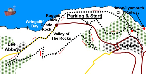
To view route as a dynamic Ordnance Survey map click here. Introduction: The Valley of Rocks is a dramatic ‘U’ shaped valley on the northern fringe of Exmoor. It was originally carved by the East Lyn River when the Ice Age blocked its true path. The ice retreated, the river returned to its rightful place and the valley subsequently silted up to form the shape it is today. As the name suggests, it is famous for its dramatic rocky outcrops poised above the high cliffs which of course have been given particular names such as Rugged Jack and Castle Rock. Feral goats are supposed to roam but I did not see any, perhaps because I opted to follow the coast path rather than climb over the outcrops themselves. I had a lazy day! You can of course just drive to the valley to see the rocks and there are car parks and a road through the valley but where’s the fun in that? In any case, by following the ridge I describe you get truly stunning views of the rocks themselves but also over Lee Bay to the sea and of the surrounding countryside. Lee Bay can be visited with a small detour when you get to Lee Abbey, if desired. Lee Abbey is a Gothic Revival building, though the site was a ‘proper’ abbey at one time. The building there now is an imposing structure and has variously been a school and hotel. It is now a Christian Retreat. It is of course possible to end this walk after having a closer look at the rocks and return to the car park but I decided to follow the Coast Path to see Linton and its famous cliff railway down to (and more importantly up from!) Lynmouth. Lynmouth was the victim of a devastating flood in 1952 following an intense storm. There was much structural damage and 34 died. Many were made homeless. Linton is quite a classy place with some nice independent shops. Exit from the town on this walk is via a dramatic ravine. The path leads through pleasant woodland back to the Valley of the Rocks and you get more great views in the process. The cliff top path tarmac covered but there are a couple of places where anyone so inclined might have vertigo worries. The walk starts at a car park in the valley floor of the Valley of the Rocks. The easiest way there I can describe is to turn off for Linton where signposted off the A39 at Barbrook and along the B3234. The turn is signposted for Linton, Lynmouth and there is a brown tourist sign for the Cliff Railway. Turn left at a sign for “Linton ¾” up Station Hill. After 0.8 of a mile, at a sharp right hand bend, it becomes Lydiate Lane. Turn left along Crossmead where (unhelpfully for the first time) there is a road sign for the Valley of Rocks. You have to go that way as straight on is “No Entry”. At the end of Crossmead, turn left. You now follow this road for half a mile. Note you want the second car park you come to on the left which has a sign for “Exmoor National Park” and “Valley of Rocks”. It is pay and display. Start: From the car park (SS 711497), take the broad grassy track out of the rear up the hill, passing a graveyard on the left. Enter a pleasant, broad leafed woodland and turn left to join another path.
Meet
another path and turn left again. You soon meet yet another footpath by a fingerpost pointing to the Valley of the Rocks back the way you have come. Turn right following the fingerpost for “Lee Abbey and Lee Bay via South Cleve”. The path climbs gently and on coming out of the trees, there is a superb view of the rocks below. Continue to follow the path along the ridge where the views continue, out to sea across Lee Bay and over pleasant countryside.
Keep following the obvious path as it zig-zags down the hill. You will pass two forks but at each, keep left descending until the path splits at a fingerpost. Turn right for “Bridleway Lee Abbey ½”. At a junction with a broad track, just after passing some crags, turn right for “Bridleway Lee Abbey ¼ mile” (SS 696490) and on reaching the road, turn right along it.
The first of the Valley of the Rocks outcrop you come to on the left is Castle Rock by a roundabout. Cross over the roundabout and take the footpath to the left of the outcrop. The path has a fingerpost for “Coast Path and Lynmouth 1¼ miles”. You now follow the path along the cliff top. It is a reasonably wide tarmac path so is an easy walk, though you must be careful of the drops!
You will pass a fingerpost for “Hollerday Hill”. This will give you a short if steep route back to the car park if time is short but otherwise continue on the coast path.
At SS 715499 pass a turn on the left down a steep path to Lynmouth, should you wish to visit. You can always catch the cliff railway back up the hill! Otherwise, continue to follow the path.
Eventually, the path becomes a lane and crosses over the Lynton/Lynmouth cliff railway track. When you get to the road junction, turn right uphill (SS 720 496).
At the top of the road, turn right again to walk along Linton’s main street. Look out for the Town Hall on the right and turn right up the lane to its right. The Town Hall is pretty unmistakeable with its mixture of mock-Gothic, neo-Tudor and art nouveau design.
As you get to the top of the rise, turn left following the fingerpost for “Hollerday Hill”, soon passing through a rocky ravine.
Continue to follow the path until you get to a three-way fingerpost. Turn left following “Hollerday House (site of)”. At SS 716495 there is a four way fingerpost. Follow “Valley of the Rocks ½ mile”. Ignore the next turn on the left which you quickly arrive at. Pass a faint turn on the right, after which the main track divides (SS 715496). There is a three way fingerpost. Take the left fork for “Valley of the Rocks”.
At another junction, again with a three way fingerpost turn left again for the Valley of the Rocks. You will now be able to see the cemetery which you passed on the outward route. Arrive at the road by a well maintained shelter known as Poets Corner. Turn left to return to the car park. If you need to buy any hiking equipment/clothing before your trip see the Hiking Store All information on this site is given in good faith and no liability is accepted in respect of any damage, loss or injury which might result from acting on it.
| | |||||||||||||||||

.jpg)
.jpg)
.jpg)
%20Path%20to%20the%20ridge.jpg)
%20Panorama%20of%20the%20Valley%20of%20The%20Rocks.jpg)
%20Lee%20Abbey.jpg)
%20Lee%20Abbey.jpg)
%20Castle%20Rock.jpg)
%20Rugged%20Jack%20or%20Chimney%20Rock.jpg)
%20View%20South%20along%20the%20coast.jpg)
%20Lynmouth%20Bay.jpg)
%20Cliff%20railway.jpg)
%20Town%20Hall.jpg)
%20Footpath%20through%20gorge%20at%20Linton.jpg)
%20Looking%20along%20the%20valley%20of%20the%20rocks.jpg)